

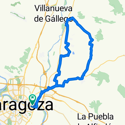
Zaragoza to Lecinena loop (actual)
A cycling route starting in Zaragoza, Aragon, Spain.
Overview
About this route
NEED GRAVEL BIKE OR MTB FOR PARTS OF THIS ROUTE. This was an attempt to follow a route that was based on Google Maps bike routing that was loaded into BikeMap (see planned route of same name). The first part out of town (left side of loop) is thru an industrial area -- no shoulder, but (mostly) two lanes in each direction. The cut to the east from this part over to the main north road (A-123) was on bad dirt/gravel/rock roads. Had to backtrack a lot as encountered closed gates not shown in Google or BikeMap. Probably better just to stay on A-123 out of town as it has good shoulders. The ENE route through the country side was pretty and mostly suitable for a gravel bike. There was one washed out uphill stretch of about 50 m we had to walk because it simply was too much for our 1.5" tires. It took us about 3 hours to cover the 21 miles to Lecinena - relatively poor quality of the gravel kept our speeds below 8 mph.
We had lunch at Bar Restaurante Piscinas (shows up on Google, but not TripAdvisor). Hearty food in very large portions, good cold beer and cheap - 2 beers, 2 sodas, and 2 lunches (two large plates each) for 25 euro. It's good that the way back to Zaragoza is mostly downhill because we ate too much.
The ride back was relatively quick as we kept to the main road A-129, which has a good shoulder. There's some decent uphills getting out of town, and one or two along the way, but from the peak you get some really decent downhill until you hit the river basin of the Ebro. The route in through Zaragoza was programmed on the fly in Google Maps and probably isn't the best way into town.
- 5 h 21 min
- Duration
- 64.7 km
- Distance
- 1,180 m
- Ascent
- 1,169 m
- Descent
- 12.1 km/h
- Avg. speed
- ---
- Max. altitude

Route quality
Waytypes & surfaces along the route
Waytypes
Track
22 km
(34 %)
Quiet road
10.3 km
(16 %)
Surfaces
Paved
15.5 km
(24 %)
Unpaved
8.4 km
(13 %)
Asphalt
14.9 km
(23 %)
Gravel
5.8 km
(9 %)
Continue with Bikemap
Use, edit, or download this cycling route
You would like to ride Zaragoza to Lecinena loop (actual) or customize it for your own trip? Here is what you can do with this Bikemap route:
Free features
- Save this route as favorite or in collections
- Copy & plan your own version of this route
- Sync your route with Garmin or Wahoo
Premium features
Free trial for 3 days, or one-time payment. More about Bikemap Premium.
- Navigate this route on iOS & Android
- Export a GPX / KML file of this route
- Create your custom printout (try it for free)
- Download this route for offline navigation
Discover more Premium features.
Get Bikemap PremiumFrom our community
Other popular routes starting in Zaragoza
 Quick ride through Zaragoza
- Distance
- 6.4 km
- Ascent
- 78 m
- Descent
- 78 m
- Location
- Zaragoza, Aragon, Spain
 Zaragoza to Lecinena loop (plan)
- Distance
- 65.7 km
- Ascent
- 359 m
- Descent
- 351 m
- Location
- Zaragoza, Aragon, Spain
 ZARAGOZA-LAS PLANAS PROGRESIVA-EL MONTAÑES
- Distance
- 58.6 km
- Ascent
- 489 m
- Descent
- 489 m
- Location
- Zaragoza, Aragon, Spain
 Zaragoza Galachos Juslibol
- Distance
- 28.3 km
- Ascent
- 51 m
- Descent
- 58 m
- Location
- Zaragoza, Aragon, Spain
 Parque Tío Jorge - Anillo Verde - Parque Tío Jorge
- Distance
- 31.9 km
- Ascent
- 128 m
- Descent
- 126 m
- Location
- Zaragoza, Aragon, Spain
 Almuerzo en Peñaflor
- Distance
- 40 km
- Ascent
- 118 m
- Descent
- 116 m
- Location
- Zaragoza, Aragon, Spain
 Sotos
Sotos- Distance
- 37.1 km
- Ascent
- 90 m
- Descent
- 89 m
- Location
- Zaragoza, Aragon, Spain
 cvcvcv
- Distance
- 15.3 km
- Ascent
- 100 m
- Descent
- 104 m
- Location
- Zaragoza, Aragon, Spain
Open it in the app