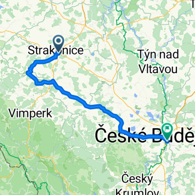
Číšť_ČB
A cycling route starting in Strakonice, Jihočeský kraj, Czechia.
Overview
About this route
-
- 2019; Ivan Wiedermann, Jaromír
- -:--
- Duration
- 68.5 km
- Distance
- 483 m
- Ascent
- 509 m
- Descent
- ---
- Avg. speed
- ---
- Avg. speed
Route quality
Waytypes & surfaces along the route
Waytypes
Road
24.1 km
(35 %)
Quiet road
15.6 km
(23 %)
Surfaces
Paved
45.4 km
(66 %)
Unpaved
3.9 km
(6 %)
Asphalt
42.2 km
(62 %)
Gravel
2.1 km
(3 %)
Continue with Bikemap
Use, edit, or download this cycling route
You would like to ride Číšť_ČB or customize it for your own trip? Here is what you can do with this Bikemap route:
Free features
- Save this route as favorite or in collections
- Copy & plan your own version of this route
- Sync your route with Garmin or Wahoo
Premium features
Free trial for 3 days, or one-time payment. More about Bikemap Premium.
- Navigate this route on iOS & Android
- Export a GPX / KML file of this route
- Create your custom printout (try it for free)
- Download this route for offline navigation
Discover more Premium features.
Get Bikemap PremiumFrom our community
Other popular routes starting in Strakonice
- Strakonice - Písek - Čížová
- Distance
- 76.7 km
- Ascent
- 440 m
- Descent
- 440 m
- Location
- Strakonice, Jihočeský kraj, Czechia
- Pumptrack Strakonice
- Distance
- 0.2 km
- Ascent
- 0 m
- Descent
- 0 m
- Location
- Strakonice, Jihočeský kraj, Czechia
- Strakonice - Volyně
- Distance
- 12.8 km
- Ascent
- 165 m
- Descent
- 112 m
- Location
- Strakonice, Jihočeský kraj, Czechia
- Číšť_ČB
- Distance
- 68.5 km
- Ascent
- 483 m
- Descent
- 509 m
- Location
- Strakonice, Jihočeský kraj, Czechia
- Strakonice - Krty
- Distance
- 17.8 km
- Ascent
- 102 m
- Descent
- 116 m
- Location
- Strakonice, Jihočeský kraj, Czechia
- Strakonice - Volyně - Helfemburk
- Distance
- 67.6 km
- Ascent
- 750 m
- Descent
- 750 m
- Location
- Strakonice, Jihočeský kraj, Czechia
- 25.7.2010
- Distance
- 97.2 km
- Ascent
- 1,025 m
- Descent
- 1,025 m
- Location
- Strakonice, Jihočeský kraj, Czechia
- Číšť - ČB
- Distance
- 55.4 km
- Ascent
- 317 m
- Descent
- 346 m
- Location
- Strakonice, Jihočeský kraj, Czechia
Open it in the app