
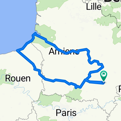
1996_05_Soissons_Lac de Madine
A cycling route starting in Soissons, Hauts-de-France, France.
Overview
About this route
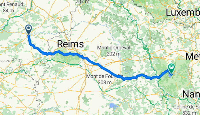
km 29 intermediate sprint
km 64 cote de sermiers 4
km 111 intermediate sprint
km 206 intermediate sprint
km 210 cote du Lion 3
- -:--
- Duration
- 232.8 km
- Distance
- 817 m
- Ascent
- 655 m
- Descent
- ---
- Avg. speed
- ---
- Max. altitude

Route quality
Waytypes & surfaces along the route
Waytypes
Track
41.9 km
(18 %)
Road
27.9 km
(12 %)
Surfaces
Paved
83.8 km
(36 %)
Unpaved
7 km
(3 %)
Asphalt
83.8 km
(36 %)
Gravel
4.7 km
(2 %)
Continue with Bikemap
Use, edit, or download this cycling route
You would like to ride 1996_05_Soissons_Lac de Madine or customize it for your own trip? Here is what you can do with this Bikemap route:
Free features
- Save this route as favorite or in collections
- Copy & plan your own version of this route
- Split it into stages to create a multi-day tour
- Sync your route with Garmin or Wahoo
Premium features
Free trial for 3 days, or one-time payment. More about Bikemap Premium.
- Navigate this route on iOS & Android
- Export a GPX / KML file of this route
- Create your custom printout (try it for free)
- Download this route for offline navigation
Discover more Premium features.
Get Bikemap PremiumFrom our community
Other popular routes starting in Soissons
 Dag 6 fredag 6.7.18
- Distance
- 75.8 km
- Ascent
- 303 m
- Descent
- 320 m
- Location
- Soissons, Hauts-de-France, France
 De Rue du Rempart Saint-Martin 12, Soissons à Rue d'Estrées 3, Soissons
- Distance
- 49.2 km
- Ascent
- 529 m
- Descent
- 531 m
- Location
- Soissons, Hauts-de-France, France
 Boulevard Jeanne d'Arc, Soissons to Rue Jean Chandon-Moët, Épernay
- Distance
- 84.2 km
- Ascent
- 790 m
- Descent
- 757 m
- Location
- Soissons, Hauts-de-France, France
 Soissons-Villers Saint Paul
- Distance
- 75.7 km
- Ascent
- 304 m
- Descent
- 334 m
- Location
- Soissons, Hauts-de-France, France
 veloplanner_route_1-08-2025
- Distance
- 597.7 km
- Ascent
- 1,523 m
- Descent
- 1,522 m
- Location
- Soissons, Hauts-de-France, France
 TR-Jkl-2016 - ajopäivä 6
- Distance
- 91.2 km
- Ascent
- 441 m
- Descent
- 470 m
- Location
- Soissons, Hauts-de-France, France
 De Rue du Rempart Saint-Martin 14, Soissons à Rue du Rempart Saint-Martin 12, Soissons
- Distance
- 49.3 km
- Ascent
- 459 m
- Descent
- 453 m
- Location
- Soissons, Hauts-de-France, France
 Route de France Femine 2013 Prologue
- Distance
- 3.8 km
- Ascent
- 13 m
- Descent
- 14 m
- Location
- Soissons, Hauts-de-France, France
Open it in the app