

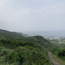
shonxi to ilan
A cycling route starting in Keelung, Taiwan, Taiwan.
Overview
About this route
shonxi to ilan
- -:--
- Duration
- 57.1 km
- Distance
- 131 m
- Ascent
- 153 m
- Descent
- ---
- Avg. speed
- ---
- Max. altitude

Route quality
Waytypes & surfaces along the route
Waytypes
Cycleway
10.3 km
(18 %)
Access road
5.1 km
(9 %)
Surfaces
Paved
45.7 km
(80 %)
Asphalt
45.7 km
(80 %)
Undefined
11.4 km
(20 %)
Continue with Bikemap
Use, edit, or download this cycling route
You would like to ride shonxi to ilan or customize it for your own trip? Here is what you can do with this Bikemap route:
Free features
- Save this route as favorite or in collections
- Copy & plan your own version of this route
- Sync your route with Garmin or Wahoo
Premium features
Free trial for 3 days, or one-time payment. More about Bikemap Premium.
- Navigate this route on iOS & Android
- Export a GPX / KML file of this route
- Create your custom printout (try it for free)
- Download this route for offline navigation
Discover more Premium features.
Get Bikemap PremiumFrom our community
Other popular routes starting in Keelung
 中等路線 羅東鎮
- Distance
- 63 km
- Ascent
- 357 m
- Descent
- 611 m
- Location
- Keelung, Taiwan, Taiwan
 2022-04-17 09:40:42 單車平溪灰窯瀑布繞行基隆河自行車道
- Distance
- 95.2 km
- Ascent
- 2,330 m
- Descent
- 2,326 m
- Location
- Keelung, Taiwan, Taiwan
 第 50 碇
- Distance
- 19 km
- Ascent
- 371 m
- Descent
- 368 m
- Location
- Keelung, Taiwan, Taiwan
 龜吼往台北 3
- Distance
- 34 km
- Ascent
- 322 m
- Descent
- 315 m
- Location
- Keelung, Taiwan, Taiwan
 一日東雙塔/瑞芳車站-三貂角燈塔-鵝巒鼻燈塔
- Distance
- 502.9 km
- Ascent
- 1,436 m
- Descent
- 1,456 m
- Location
- Keelung, Taiwan, Taiwan
 TUAA 不厭‧五分 雙峰挑戰 2011 KOM「快樂登山王‧騎士模擬考」
- Distance
- 57.7 km
- Ascent
- 1,428 m
- Descent
- 1,425 m
- Location
- Keelung, Taiwan, Taiwan
 友蚋溪谷
友蚋溪谷- Distance
- 20.8 km
- Ascent
- 855 m
- Descent
- 314 m
- Location
- Keelung, Taiwan, Taiwan
 基隆鳶飛百客固定夜騎-星期一大坪國小
- Distance
- 21.8 km
- Ascent
- 541 m
- Descent
- 467 m
- Location
- Keelung, Taiwan, Taiwan
Open it in the app