Telfs - Mötz - Badesee Mieming - Telfs
A cycling route starting in Oberhofen im Inntal, Tyrol, Austria.
Overview
About this route
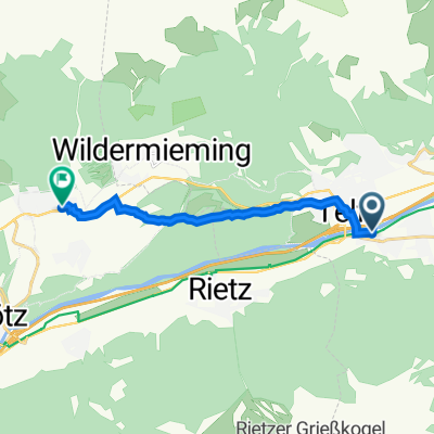
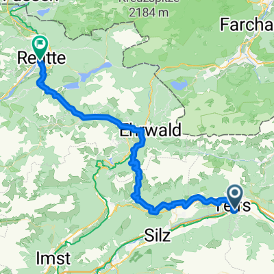
The start and end point of the route is the parking lot at the 'Telfs/Pfaffenhofen' train station (the parking lot will soon be replaced by a parking garage!). The route continues to Rietz, Stams, and Mötz. From Mötz, a very steep, paved path leads up to the Mieming Plateau and the Mieming bathing lake. Here you can take the opportunity to swim! (Admission €6). Then it continues through Unter- and Obermieming to Wildermieming and from there on beautiful paths back to Telfs at the starting point.
- -:--
- Duration
- 30.1 km
- Distance
- 413 m
- Ascent
- 414 m
- Descent
- ---
- Avg. speed
- ---
- Max. altitude
Route quality
Waytypes & surfaces along the route
Waytypes
Quiet road
14.1 km
(47 %)
Track
12.9 km
(43 %)
Surfaces
Paved
16 km
(53 %)
Unpaved
6.6 km
(22 %)
Asphalt
15.7 km
(52 %)
Gravel
6.6 km
(22 %)
Continue with Bikemap
Use, edit, or download this cycling route
You would like to ride Telfs - Mötz - Badesee Mieming - Telfs or customize it for your own trip? Here is what you can do with this Bikemap route:
Free features
- Save this route as favorite or in collections
- Copy & plan your own version of this route
- Sync your route with Garmin or Wahoo
Premium features
Free trial for 3 days, or one-time payment. More about Bikemap Premium.
- Navigate this route on iOS & Android
- Export a GPX / KML file of this route
- Create your custom printout (try it for free)
- Download this route for offline navigation
Discover more Premium features.
Get Bikemap PremiumFrom our community
Other popular routes starting in Oberhofen im Inntal
- Pfaffenhofer Alm
- Distance
- 7.9 km
- Ascent
- 1,039 m
- Descent
- 22 m
- Location
- Oberhofen im Inntal, Tyrol, Austria
- Pfaffenhofener Alm
- Distance
- 8.5 km
- Ascent
- 1,224 m
- Descent
- 281 m
- Location
- Oberhofen im Inntal, Tyrol, Austria
- Pfaffenhofener Alm (MTB)
- Distance
- 9 km
- Ascent
- 1,065 m
- Descent
- 5 m
- Location
- Oberhofen im Inntal, Tyrol, Austria
- Telfs - Mötz - Badesee Mieming - Telfs
- Distance
- 30.1 km
- Ascent
- 413 m
- Descent
- 414 m
- Location
- Oberhofen im Inntal, Tyrol, Austria
- Telfsneu
- Distance
- 18 km
- Ascent
- 641 m
- Descent
- 150 m
- Location
- Oberhofen im Inntal, Tyrol, Austria
- Telfs - Nassreith - Fernpass - Ehrwald - Gaistal
- Distance
- 77.8 km
- Ascent
- 1,928 m
- Descent
- 1,924 m
- Location
- Oberhofen im Inntal, Tyrol, Austria
- 20231003-[H] Bike Point Innsbruck
- Distance
- 31.2 km
- Ascent
- 77 m
- Descent
- 132 m
- Location
- Oberhofen im Inntal, Tyrol, Austria
- 20230915-[H] Sportplatz Neu-Rum
- Distance
- 34 km
- Ascent
- 122 m
- Descent
- 190 m
- Location
- Oberhofen im Inntal, Tyrol, Austria
Open it in the app