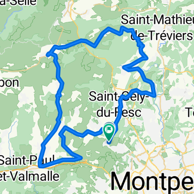
balade facile
A cycling route starting in Grabels, Languedoc-Roussillon-Midi-Pyrénées, France.
Overview
About this route
- -:--
- Duration
- 47 km
- Distance
- 439 m
- Ascent
- 439 m
- Descent
- ---
- Avg. speed
- ---
- Avg. speed
Route quality
Waytypes & surfaces along the route
Waytypes
Road
37.2 km
(79 %)
Quiet road
5.2 km
(11 %)
Surfaces
Paved
21.6 km
(46 %)
Asphalt
21.6 km
(46 %)
Undefined
25.4 km
(54 %)
Continue with Bikemap
Use, edit, or download this cycling route
You would like to ride balade facile or customize it for your own trip? Here is what you can do with this Bikemap route:
Free features
- Save this route as favorite or in collections
- Copy & plan your own version of this route
- Sync your route with Garmin or Wahoo
Premium features
Free trial for 3 days, or one-time payment. More about Bikemap Premium.
- Navigate this route on iOS & Android
- Export a GPX / KML file of this route
- Create your custom printout (try it for free)
- Download this route for offline navigation
Discover more Premium features.
Get Bikemap PremiumFrom our community
Other popular routes starting in Grabels
- GRA-MTP-PAL-LAT
- Distance
- 76.1 km
- Ascent
- 273 m
- Descent
- 272 m
- Location
- Grabels, Languedoc-Roussillon-Midi-Pyrénées, France
- Grabels-Val du Hérault 85 Route à Merveille
- Distance
- 87.2 km
- Ascent
- 1,105 m
- Descent
- 1,108 m
- Location
- Grabels, Languedoc-Roussillon-Midi-Pyrénées, France
- Malbosc - Taillade - La Boissière
- Distance
- 77.7 km
- Ascent
- 603 m
- Descent
- 603 m
- Location
- Grabels, Languedoc-Roussillon-Midi-Pyrénées, France
- A/R à Saint Gély du Fesc
- Distance
- 21.3 km
- Ascent
- 245 m
- Descent
- 237 m
- Location
- Grabels, Languedoc-Roussillon-Midi-Pyrénées, France
- Balade au pied du Pic Saint-Loup
- Distance
- 44.8 km
- Ascent
- 250 m
- Descent
- 247 m
- Location
- Grabels, Languedoc-Roussillon-Midi-Pyrénées, France
- Grabels-Val du Hérault 93
- Distance
- 93.2 km
- Ascent
- 1,139 m
- Descent
- 1,140 m
- Location
- Grabels, Languedoc-Roussillon-Midi-Pyrénées, France
- cote de bel air
- Distance
- 4.2 km
- Ascent
- 94 m
- Descent
- 15 m
- Location
- Grabels, Languedoc-Roussillon-Midi-Pyrénées, France
- 59 Rue du Château, Grabels nach 198 Route de Bel Air, Grabels
- Distance
- 87.4 km
- Ascent
- 1,042 m
- Descent
- 1,046 m
- Location
- Grabels, Languedoc-Roussillon-Midi-Pyrénées, France
Open it in the app