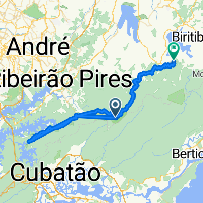
Trilha Porteira Preta, Parte Baixa
A cycling route starting in Rio Grande da Serra, São Paulo, Brazil.
Overview
About this route
- -:--
- Duration
- 30.4 km
- Distance
- 398 m
- Ascent
- 396 m
- Descent
- ---
- Avg. speed
- ---
- Max. altitude
Route quality
Waytypes & surfaces along the route
Waytypes
Road
16.4 km
(54 %)
Quiet road
14 km
(46 %)
Surfaces
Unpaved
30.4 km
(100 %)
Ground
23.7 km
(78 %)
Unpaved (undefined)
6.7 km
(22 %)
Continue with Bikemap
Use, edit, or download this cycling route
You would like to ride Trilha Porteira Preta, Parte Baixa or customize it for your own trip? Here is what you can do with this Bikemap route:
Free features
- Save this route as favorite or in collections
- Copy & plan your own version of this route
- Sync your route with Garmin or Wahoo
Premium features
Free trial for 3 days, or one-time payment. More about Bikemap Premium.
- Navigate this route on iOS & Android
- Export a GPX / KML file of this route
- Create your custom printout (try it for free)
- Download this route for offline navigation
Discover more Premium features.
Get Bikemap PremiumFrom our community
Other popular routes starting in Rio Grande da Serra
- Rio Grande da Serra-Paranapiacaba
- Distance
- 12.9 km
- Ascent
- 277 m
- Descent
- 200 m
- Location
- Rio Grande da Serra, São Paulo, Brazil
- Trilha da Torta + Sabão
- Distance
- 30 km
- Ascent
- 411 m
- Descent
- 411 m
- Location
- Rio Grande da Serra, São Paulo, Brazil
- Paranapiacaba - Quatinga via Taquaruçu
- Distance
- 38.5 km
- Ascent
- 446 m
- Descent
- 452 m
- Location
- Rio Grande da Serra, São Paulo, Brazil
- Trilha em Paranapiacaba
- Distance
- 34.2 km
- Ascent
- 406 m
- Descent
- 406 m
- Location
- Rio Grande da Serra, São Paulo, Brazil
- Paranapiacaba
- Distance
- 12.1 km
- Ascent
- 364 m
- Descent
- 355 m
- Location
- Rio Grande da Serra, São Paulo, Brazil
- Terra 56KM Paranapiacaba
- Distance
- 58 km
- Ascent
- 546 m
- Descent
- 548 m
- Location
- Rio Grande da Serra, São Paulo, Brazil
- Paranapiacaba x Magic City x Taquarussu x Paranapiacaba
- Distance
- 41.3 km
- Ascent
- 619 m
- Descent
- 617 m
- Location
- Rio Grande da Serra, São Paulo, Brazil
- Trilha da Torta
- Distance
- 30.2 km
- Ascent
- 323 m
- Descent
- 323 m
- Location
- Rio Grande da Serra, São Paulo, Brazil
Open it in the app