

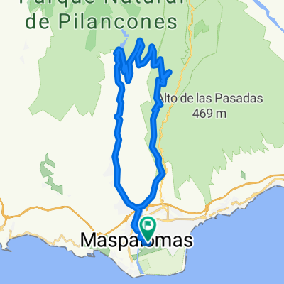
04. Grand Canyon
A cycling route starting in Maspalomas, Canary Islands, Spain.
Overview
About this route
- -:--
- Duration
- 40.3 km
- Distance
- 579 m
- Ascent
- 579 m
- Descent
- ---
- Avg. speed
- ---
- Max. altitude

Route quality
Waytypes & surfaces along the route
Waytypes
Track
20.3 km
(50 %)
Road
14.8 km
(37 %)
Surfaces
Paved
15.8 km
(39 %)
Unpaved
20 km
(50 %)
Unpaved (undefined)
18.5 km
(46 %)
Asphalt
15.6 km
(39 %)
Route highlights
Points of interest along the route
Point of interest after 13.8 km
Pause
Point of interest after 14 km
Pause
Point of interest after 16.9 km
Point of interest after 19.4 km
Point of interest after 22.7 km
Point of interest after 26.1 km
Alternative Route
Continue with Bikemap
Use, edit, or download this cycling route
You would like to ride 04. Grand Canyon or customize it for your own trip? Here is what you can do with this Bikemap route:
Free features
- Save this route as favorite or in collections
- Copy & plan your own version of this route
- Sync your route with Garmin or Wahoo
Premium features
Free trial for 3 days, or one-time payment. More about Bikemap Premium.
- Navigate this route on iOS & Android
- Export a GPX / KML file of this route
- Create your custom printout (try it for free)
- Download this route for offline navigation
Discover more Premium features.
Get Bikemap PremiumFrom our community
Other popular routes starting in Maspalomas
 maspalomas-vicentes-ayagaures-maspalomas
- Distance
- 34.4 km
- Ascent
- 1,602 m
- Descent
- 1,603 m
- Location
- Maspalomas, Canary Islands, Spain
 Koenigsetappe_GranCan2015
- Distance
- 183.5 km
- Ascent
- 3,154 m
- Descent
- 3,154 m
- Location
- Maspalomas, Canary Islands, Spain
 Light Gran Canaria
- Distance
- 52.6 km
- Ascent
- 2,320 m
- Descent
- 2,192 m
- Location
- Maspalomas, Canary Islands, Spain
 Playa del ingles - Tal der Tränen
- Distance
- 121.9 km
- Ascent
- 3,008 m
- Descent
- 3,008 m
- Location
- Maspalomas, Canary Islands, Spain
 GC Maspalomas
- Distance
- 35.1 km
- Ascent
- 1,595 m
- Descent
- 1,561 m
- Location
- Maspalomas, Canary Islands, Spain
 los palmitos
- Distance
- 28.4 km
- Ascent
- 480 m
- Descent
- 552 m
- Location
- Maspalomas, Canary Islands, Spain
 04. Grand Canyon
- Distance
- 40.3 km
- Ascent
- 579 m
- Descent
- 579 m
- Location
- Maspalomas, Canary Islands, Spain
 EL TABLERO-JUAN GRANDE
- Distance
- 18.4 km
- Ascent
- 124 m
- Descent
- 204 m
- Location
- Maspalomas, Canary Islands, Spain
Open it in the app