

Zaragoza to Garrapinillos (actual)
A cycling route starting in Zaragoza, Aragon, Spain.
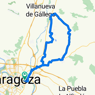
Overview
About this route
The road along the canal is poorly-maintained gravel. Definitely would be good to have suspension MTB or a gravel bike that has handlebar vibration absorbers. I do not recommend the route that we took to get to the canal -- the GPS had issues with some of the buildings and we missed several turns -- so if you use this you want to fix the first 3 miles. Nice town square in Garrapinillos with several restaurants.
- 1 h 47 min
- Duration
- 23.7 km
- Distance
- 436 m
- Ascent
- 406 m
- Descent
- 13.3 km/h
- Avg. speed
- ---
- Max. altitude

Continue with Bikemap
Use, edit, or download this cycling route
You would like to ride Zaragoza to Garrapinillos (actual) or customize it for your own trip? Here is what you can do with this Bikemap route:
Free features
- Save this route as favorite or in collections
- Copy & plan your own version of this route
- Sync your route with Garmin or Wahoo
Premium features
Free trial for 3 days, or one-time payment. More about Bikemap Premium.
- Navigate this route on iOS & Android
- Export a GPX / KML file of this route
- Create your custom printout (try it for free)
- Download this route for offline navigation
Discover more Premium features.
Get Bikemap PremiumFrom our community
Other popular routes starting in Zaragoza
 Zaragoza - Presa de Pina
- Distance
- 48.9 km
- Ascent
- 119 m
- Descent
- 119 m
- Location
- Zaragoza, Aragon, Spain
 Villamayor - La Puebla de Alfinden
- Distance
- 36.4 km
- Ascent
- 94 m
- Descent
- 94 m
- Location
- Zaragoza, Aragon, Spain
 Almuerzo en Peñaflor
- Distance
- 40 km
- Ascent
- 118 m
- Descent
- 116 m
- Location
- Zaragoza, Aragon, Spain
 sanjose-cartuja-expo-z30-canal-sanjose
- Distance
- 34.2 km
- Ascent
- 128 m
- Descent
- 128 m
- Location
- Zaragoza, Aragon, Spain
 5ª etapa Ebro 2002.
- Distance
- 142.1 km
- Ascent
- 572 m
- Descent
- 718 m
- Location
- Zaragoza, Aragon, Spain
 ZARAGOZA-LAS PLANAS PROGRESIVA-EL MONTAÑES
- Distance
- 58.6 km
- Ascent
- 489 m
- Descent
- 489 m
- Location
- Zaragoza, Aragon, Spain
 Parque Tío Jorge - Anillo Verde - Parque Tío Jorge
- Distance
- 31.9 km
- Ascent
- 128 m
- Descent
- 126 m
- Location
- Zaragoza, Aragon, Spain
 cvcvcv
- Distance
- 15.3 km
- Ascent
- 100 m
- Descent
- 104 m
- Location
- Zaragoza, Aragon, Spain
Open it in the app