
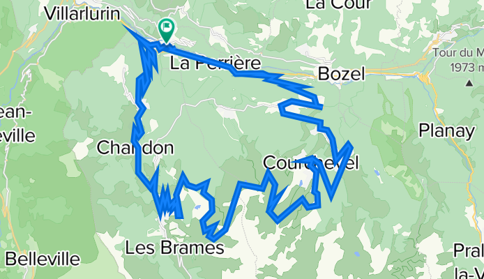
Col de la Loze
A cycling route starting in Les Allues, Auvergne-Rhône-Alpes, France.
Overview
About this route
New paved road above Courchevel closed to cyclists for final 6 kilometres.
- -:--
- Duration
- 51.4 km
- Distance
- 1,699 m
- Ascent
- 1,704 m
- Descent
- ---
- Avg. speed
- ---
- Max. altitude

Route quality
Waytypes & surfaces along the route
Waytypes
Busy road
25.7 km
(50 %)
Quiet road
18.7 km
(36 %)
Surfaces
Paved
31.6 km
(62 %)
Unpaved
1.1 km
(2 %)
Asphalt
31.6 km
(62 %)
Ground
0.8 km
(2 %)
Route highlights
Points of interest along the route
Point of interest after 29.4 km
Col de la Loze - 2304 metres
Continue with Bikemap
Use, edit, or download this cycling route
You would like to ride Col de la Loze or customize it for your own trip? Here is what you can do with this Bikemap route:
Free features
- Save this route as favorite or in collections
- Copy & plan your own version of this route
- Sync your route with Garmin or Wahoo
Premium features
Free trial for 3 days, or one-time payment. More about Bikemap Premium.
- Navigate this route on iOS & Android
- Export a GPX / KML file of this route
- Create your custom printout (try it for free)
- Download this route for offline navigation
Discover more Premium features.
Get Bikemap PremiumFrom our community
Other popular routes starting in Les Allues
 Z4 - Col de la Loze mai usor
- Distance
- 54.3 km
- Ascent
- 1,706 m
- Descent
- 1,705 m
- Location
- Les Allues, Auvergne-Rhône-Alpes, France
 etape_17_meribel
- Distance
- 14.8 km
- Ascent
- 1,149 m
- Descent
- 0 m
- Location
- Les Allues, Auvergne-Rhône-Alpes, France
 100KM Col de la Loze by Brides les Bains
- Distance
- 100.6 km
- Ascent
- 4,475 m
- Descent
- 2,796 m
- Location
- Les Allues, Auvergne-Rhône-Alpes, France
 SC Cdla Loze
- Distance
- 46.6 km
- Ascent
- 1,691 m
- Descent
- 1,449 m
- Location
- Les Allues, Auvergne-Rhône-Alpes, France
 Meribel Loop
- Distance
- 32.9 km
- Ascent
- 1,024 m
- Descent
- 1,024 m
- Location
- Les Allues, Auvergne-Rhône-Alpes, France
 Brides-les-Bains to Courchevel Altiport
- Distance
- 42.1 km
- Ascent
- 1,362 m
- Descent
- 1,362 m
- Location
- Les Allues, Auvergne-Rhône-Alpes, France
 Col de la Loze
- Distance
- 51.4 km
- Ascent
- 1,699 m
- Descent
- 1,704 m
- Location
- Les Allues, Auvergne-Rhône-Alpes, France
 Meribel via
- Distance
- 42.2 km
- Ascent
- 1,194 m
- Descent
- 1,196 m
- Location
- Les Allues, Auvergne-Rhône-Alpes, France
Open it in the app