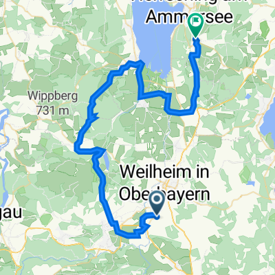
RR Murnaurunde
A cycling route starting in Polling, Bavaria, Germany.
Overview
About this route
In weitem Bogen um Murnau:
Auch diese Tour führt wieder fast nur auf Nebenwegen und asphaltierten landwirtschaftlichen Wirtschaftswegen durch die schöne oberbayerische Voralpenlandschaft. Dabei werden viele bekannte Gebiete berührt: Das Kloster Polling mit seinem schönen Biergarten, das kleine, mitten in der Landschaft stehende Kirchlein St. Andrä, der Riegsee, das Freilichtmuseum Glentleiten, das Murnauer Moos, Murnau mit seiner einladenden Innenstadt sowie der Staffelsee.
Routenvorschlag Polling - Etting - Eberfing - Obersöchering - Riegsee - Habach - Sindelsdorf - Großweil - Glentleiten - Ohlstadt - Eschenlohe - Murnauer Moos - Murnau - Staffelsee - Uffing - Hechenrain - Huglfing - Berg - Polling
- -:--
- Duration
- 96.4 km
- Distance
- 560 m
- Ascent
- 560 m
- Descent
- ---
- Avg. speed
- ---
- Avg. speed
Route quality
Waytypes & surfaces along the route
Waytypes
Quiet road
46.6 km
(48 %)
Busy road
22.2 km
(23 %)
Surfaces
Paved
81.2 km
(84 %)
Unpaved
2.6 km
(3 %)
Asphalt
74.3 km
(77 %)
Paved (undefined)
5.6 km
(6 %)
Continue with Bikemap
Use, edit, or download this cycling route
You would like to ride RR Murnaurunde or customize it for your own trip? Here is what you can do with this Bikemap route:
Free features
- Save this route as favorite or in collections
- Copy & plan your own version of this route
- Sync your route with Garmin or Wahoo
Premium features
Free trial for 3 days, or one-time payment. More about Bikemap Premium.
- Navigate this route on iOS & Android
- Export a GPX / KML file of this route
- Create your custom printout (try it for free)
- Download this route for offline navigation
Discover more Premium features.
Get Bikemap PremiumFrom our community
Other popular routes starting in Polling
- Polling - Bromberg
- Distance
- 37.7 km
- Ascent
- 283 m
- Descent
- 281 m
- Location
- Polling, Bavaria, Germany
- RR Murnaurunde
- Distance
- 96.4 km
- Ascent
- 560 m
- Descent
- 560 m
- Location
- Polling, Bavaria, Germany
- Zwischen Ammersee und Starnberger See-RR60
- Distance
- 59.3 km
- Ascent
- 324 m
- Descent
- 323 m
- Location
- Polling, Bavaria, Germany
- Weilheim Staffelsee
- Distance
- 49.6 km
- Ascent
- 293 m
- Descent
- 294 m
- Location
- Polling, Bavaria, Germany
- Weilheim - Feldafing
- Distance
- 22.4 km
- Ascent
- 219 m
- Descent
- 165 m
- Location
- Polling, Bavaria, Germany
- A2b Polling-Berghof-Peißenberg-Wessobrunn-Dießen-Andechs 51,5km 570hm
- Distance
- 51.5 km
- Ascent
- 689 m
- Descent
- 584 m
- Location
- Polling, Bavaria, Germany
- Oderding - Uffing - Rottenbuch - Peiting - Paterzell
- Distance
- 68.5 km
- Ascent
- 642 m
- Descent
- 642 m
- Location
- Polling, Bavaria, Germany
- Weilheim Feldafing
- Distance
- 22.7 km
- Ascent
- 167 m
- Descent
- 112 m
- Location
- Polling, Bavaria, Germany
Open it in the app