

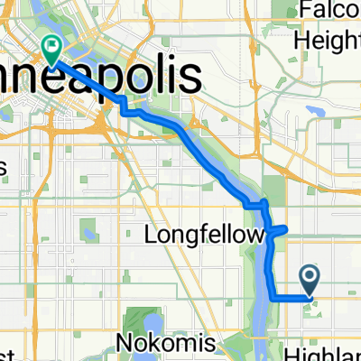
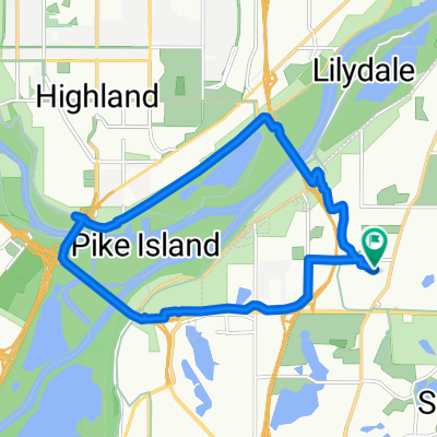
Snail-like route in Mendota Heights
A cycling route starting in Mendota Heights, Minnesota, United States.
Overview
About this route
- 49 min
- Duration
- 14 km
- Distance
- 325 m
- Ascent
- 325 m
- Descent
- 17.1 km/h
- Avg. speed
- ---
- Max. altitude
Continue with Bikemap
Use, edit, or download this cycling route
You would like to ride Snail-like route in Mendota Heights or customize it for your own trip? Here is what you can do with this Bikemap route:
Free features
- Save this route as favorite or in collections
- Copy & plan your own version of this route
- Sync your route with Garmin or Wahoo
Premium features
Free trial for 3 days, or one-time payment. More about Bikemap Premium.
- Navigate this route on iOS & Android
- Export a GPX / KML file of this route
- Create your custom printout (try it for free)
- Download this route for offline navigation
Discover more Premium features.
Get Bikemap PremiumFrom our community
Other popular routes starting in Mendota Heights
 B2B00191 55115>55401viaRandolph/MissBlvd/LkStBridge/WRiverPkwy/WashAv
- Distance
- 11.6 km
- Ascent
- 97 m
- Descent
- 109 m
- Location
- Mendota Heights, Minnesota, United States
 South Minnehaha Drive 4935-4925, Minneapolis to South Minnehaha Drive, Minneapolis
- Distance
- 39.9 km
- Ascent
- 10 m
- Descent
- 3 m
- Location
- Mendota Heights, Minnesota, United States
 B2B 55116 > 55106 via Summit Ave, Kellogg Blvd E
- Distance
- 14.3 km
- Ascent
- 40 m
- Descent
- 63 m
- Location
- Mendota Heights, Minnesota, United States
 B2B00914 55116>55435 via Mend Brg, 494 bike brg, 73rd
- Distance
- 22.6 km
- Ascent
- 141 m
- Descent
- 132 m
- Location
- Mendota Heights, Minnesota, United States
 Mendota Heights-South St.Paul
- Distance
- 35.7 km
- Ascent
- 218 m
- Descent
- 218 m
- Location
- Mendota Heights, Minnesota, United States
 Mendota to Calhoun
- Distance
- 22 km
- Ascent
- 171 m
- Descent
- 132 m
- Location
- Mendota Heights, Minnesota, United States
 The Origin
- Distance
- 28 km
- Ascent
- 173 m
- Descent
- 174 m
- Location
- Mendota Heights, Minnesota, United States
 Snail-like route in Mendota Heights
- Distance
- 14 km
- Ascent
- 325 m
- Descent
- 325 m
- Location
- Mendota Heights, Minnesota, United States
Open it in the app