

Jakupica (Izvor to Cheples)
A cycling route starting in Čaška, Čaška Municipality, North Macedonia.
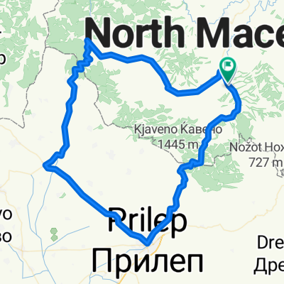
Overview
About this route
Izvor to Ceples Mountanieers Hut (& back)
- track difficulty: overall 4/5, but the last part of the track is climbing 700m in 2.5km (5/5)
- -:--
- Duration
- 37.2 km
- Distance
- 1,149 m
- Ascent
- 41 m
- Descent
- ---
- Avg. speed
- ---
- Max. altitude

Continue with Bikemap
Use, edit, or download this cycling route
You would like to ride Jakupica (Izvor to Cheples) or customize it for your own trip? Here is what you can do with this Bikemap route:
Free features
- Save this route as favorite or in collections
- Copy & plan your own version of this route
- Sync your route with Garmin or Wahoo
Premium features
Free trial for 3 days, or one-time payment. More about Bikemap Premium.
- Navigate this route on iOS & Android
- Export a GPX / KML file of this route
- Create your custom printout (try it for free)
- Download this route for offline navigation
Discover more Premium features.
Get Bikemap PremiumFrom our community
Other popular routes starting in Čaška
 Чашка-Јакупички преслап-Долнени*
- Distance
- 84.1 km
- Ascent
- 1,642 m
- Descent
- 1,279 m
- Location
- Čaška, Čaška Municipality, North Macedonia
 Стар пат за Прилеп
- Distance
- 41.6 km
- Ascent
- 818 m
- Descent
- 427 m
- Location
- Čaška, Čaška Municipality, North Macedonia
 Извор - Богомила - Чеплес
- Distance
- 84.7 km
- Ascent
- 1,138 m
- Descent
- 1,144 m
- Location
- Čaška, Čaška Municipality, North Macedonia
 Caska - Bogomila
- Distance
- 68.5 km
- Ascent
- 402 m
- Descent
- 398 m
- Location
- Čaška, Čaška Municipality, North Macedonia
 izvor-prilep-bogomila
- Distance
- 113.3 km
- Ascent
- 1,136 m
- Descent
- 1,133 m
- Location
- Čaška, Čaška Municipality, North Macedonia
 Babuna (Izvor to Nikodin)
- Distance
- 24.3 km
- Ascent
- 750 m
- Descent
- 416 m
- Location
- Čaška, Čaška Municipality, North Macedonia
 Bogomila
- Distance
- 33.5 km
- Ascent
- 521 m
- Descent
- 178 m
- Location
- Čaška, Čaška Municipality, North Macedonia
 Jakupica (Izvor to Cheples)
- Distance
- 37.2 km
- Ascent
- 1,149 m
- Descent
- 41 m
- Location
- Čaška, Čaška Municipality, North Macedonia
Open it in the app