

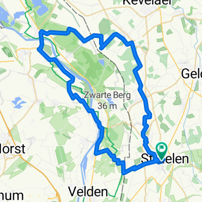
Straelen Arcen Rundkurs 1a
A cycling route starting in Straelen, North Rhine-Westphalia, Germany.
Overview
About this route
- -:--
- Duration
- 52.9 km
- Distance
- 84 m
- Ascent
- 84 m
- Descent
- ---
- Avg. speed
- ---
- Max. altitude

Route quality
Waytypes & surfaces along the route
Waytypes
Quiet road
26.6 km
(50 %)
Track
8.7 km
(16 %)
Surfaces
Paved
29.1 km
(55 %)
Unpaved
8 km
(15 %)
Asphalt
25.8 km
(49 %)
Loose gravel
4.9 km
(9 %)
Continue with Bikemap
Use, edit, or download this cycling route
You would like to ride Straelen Arcen Rundkurs 1a or customize it for your own trip? Here is what you can do with this Bikemap route:
Free features
- Save this route as favorite or in collections
- Copy & plan your own version of this route
- Sync your route with Garmin or Wahoo
Premium features
Free trial for 3 days, or one-time payment. More about Bikemap Premium.
- Navigate this route on iOS & Android
- Export a GPX / KML file of this route
- Create your custom printout (try it for free)
- Download this route for offline navigation
Discover more Premium features.
Get Bikemap PremiumFrom our community
Other popular routes starting in Straelen
 Maas Runde
- Distance
- 60.1 km
- Ascent
- 70 m
- Descent
- 70 m
- Location
- Straelen, North Rhine-Westphalia, Germany
 47 km vom Radwandertag 2012 Route 19
- Distance
- 45.6 km
- Ascent
- 51 m
- Descent
- 53 m
- Location
- Straelen, North Rhine-Westphalia, Germany
 Straelen-Kerken-Wachtendonk-Straelen, 30 Km
- Distance
- 29.3 km
- Ascent
- 44 m
- Descent
- 46 m
- Location
- Straelen, North Rhine-Westphalia, Germany
 Fahrradtour 2109
- Distance
- 19.3 km
- Ascent
- 23 m
- Descent
- 23 m
- Location
- Straelen, North Rhine-Westphalia, Germany
 Venlo und Lottum
- Distance
- 39.9 km
- Ascent
- 68 m
- Descent
- 67 m
- Location
- Straelen, North Rhine-Westphalia, Germany
 Tag 2 Straelen - Roermond
- Distance
- 44 km
- Ascent
- 80 m
- Descent
- 81 m
- Location
- Straelen, North Rhine-Westphalia, Germany
 Straelen Arcen Rundkurs 1a
- Distance
- 52.9 km
- Ascent
- 84 m
- Descent
- 84 m
- Location
- Straelen, North Rhine-Westphalia, Germany
 Heinz,Steyl-Kald. Strae.,54Km
- Distance
- 57.2 km
- Ascent
- 147 m
- Descent
- 148 m
- Location
- Straelen, North Rhine-Westphalia, Germany
Open it in the app