

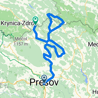
Snail-like route in Prešov
A cycling route starting in Prešov, Prešov Region, Slovakia.
Overview
About this route
- 53 min
- Duration
- 15.5 km
- Distance
- 74 m
- Ascent
- 237 m
- Descent
- 17.6 km/h
- Avg. speed
- ---
- Max. altitude

Route quality
Waytypes & surfaces along the route
Waytypes
Cycleway
9 km
(58 %)
Pedestrian area
3.3 km
(21 %)
Surfaces
Paved
12.9 km
(83 %)
Asphalt
11.3 km
(73 %)
Paved (undefined)
1.5 km
(10 %)
Undefined
2.6 km
(17 %)
Continue with Bikemap
Use, edit, or download this cycling route
You would like to ride Snail-like route in Prešov or customize it for your own trip? Here is what you can do with this Bikemap route:
Free features
- Save this route as favorite or in collections
- Copy & plan your own version of this route
- Sync your route with Garmin or Wahoo
Premium features
Free trial for 3 days, or one-time payment. More about Bikemap Premium.
- Navigate this route on iOS & Android
- Export a GPX / KML file of this route
- Create your custom printout (try it for free)
- Download this route for offline navigation
Discover more Premium features.
Get Bikemap PremiumFrom our community
Other popular routes starting in Prešov
 Okolo Domaši cez les
- Distance
- 102.8 km
- Ascent
- 669 m
- Descent
- 669 m
- Location
- Prešov, Prešov Region, Slovakia
 Slow ride in Prešov
- Distance
- 49.2 km
- Ascent
- 681 m
- Descent
- 678 m
- Location
- Prešov, Prešov Region, Slovakia
 drienovska n.ves-haniska
- Distance
- 19 km
- Ascent
- 596 m
- Descent
- 601 m
- Location
- Prešov, Prešov Region, Slovakia
 Domasa okruh
- Distance
- 107.2 km
- Ascent
- 821 m
- Descent
- 820 m
- Location
- Prešov, Prešov Region, Slovakia
 D1 do Kojatice
- Distance
- 48.8 km
- Ascent
- 504 m
- Descent
- 559 m
- Location
- Prešov, Prešov Region, Slovakia
 1ª Etapa Presovsky Tour 2015
- Distance
- 173.7 km
- Ascent
- 1,236 m
- Descent
- 986 m
- Location
- Prešov, Prešov Region, Slovakia
 Cez Cervenu mlaku
- Distance
- 41.1 km
- Ascent
- 945 m
- Descent
- 945 m
- Location
- Prešov, Prešov Region, Slovakia
 PO-Fričovce-Branisko-Bachureň-SB-PO, GPX- Minikin
- Distance
- 97.4 km
- Ascent
- 1,440 m
- Descent
- 1,439 m
- Location
- Prešov, Prešov Region, Slovakia
Open it in the app