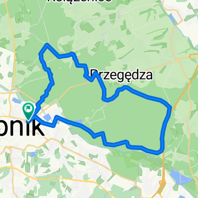
rok montanbajka
A cycling route starting in Rybnik, Silesian Voivodeship, Poland.
Overview
About this route
- -:--
- Duration
- 36.4 km
- Distance
- 206 m
- Ascent
- 206 m
- Descent
- ---
- Avg. speed
- ---
- Avg. speed
Route quality
Waytypes & surfaces along the route
Waytypes
Track
21 km
(58 %)
Path
8.8 km
(24 %)
Surfaces
Paved
6.3 km
(17 %)
Unpaved
27 km
(74 %)
Gravel
13.7 km
(38 %)
Ground
8.5 km
(23 %)
Continue with Bikemap
Use, edit, or download this cycling route
You would like to ride rok montanbajka or customize it for your own trip? Here is what you can do with this Bikemap route:
Free features
- Save this route as favorite or in collections
- Copy & plan your own version of this route
- Sync your route with Garmin or Wahoo
Premium features
Free trial for 3 days, or one-time payment. More about Bikemap Premium.
- Navigate this route on iOS & Android
- Export a GPX / KML file of this route
- Create your custom printout (try it for free)
- Download this route for offline navigation
Discover more Premium features.
Get Bikemap PremiumFrom our community
Other popular routes starting in Rybnik
- pętla 39 km Rybnik
- Distance
- 39.5 km
- Ascent
- 166 m
- Descent
- 166 m
- Location
- Rybnik, Silesian Voivodeship, Poland
- Rybnik - Kamień - Przegędza - Gotartowice - Rybnik
- Distance
- 26.9 km
- Ascent
- 188 m
- Descent
- 188 m
- Location
- Rybnik, Silesian Voivodeship, Poland
- płaska trzydziestka
- Distance
- 31.3 km
- Ascent
- 145 m
- Descent
- 144 m
- Location
- Rybnik, Silesian Voivodeship, Poland
- Szlakiem Orlich Gniazd 2017
- Distance
- 466.5 km
- Ascent
- 938 m
- Descent
- 938 m
- Location
- Rybnik, Silesian Voivodeship, Poland
- Pojezierze Palowickie z Rybnika
- Distance
- 31.5 km
- Ascent
- 137 m
- Descent
- 123 m
- Location
- Rybnik, Silesian Voivodeship, Poland
- orzepowice - kuznaia raciborska
- Distance
- 47.8 km
- Ascent
- 300 m
- Descent
- 300 m
- Location
- Rybnik, Silesian Voivodeship, Poland
- Z Rybnika na Pradziad
- Distance
- 319.6 km
- Ascent
- 1,706 m
- Descent
- 1,706 m
- Location
- Rybnik, Silesian Voivodeship, Poland
- Łatwa trasa w Rybnik
- Distance
- 15.2 km
- Ascent
- 229 m
- Descent
- 231 m
- Location
- Rybnik, Silesian Voivodeship, Poland
Open it in the app