

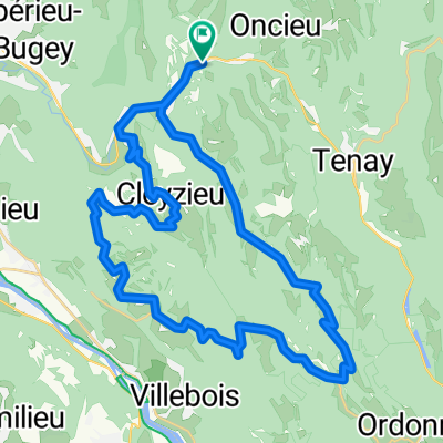
Saint-Rambert - Indrieux - Plomb - Tenay
A cycling route starting in Saint-Rambert-en-Bugey, Auvergne-Rhône-Alpes, France.
Overview
About this route
- 1 h 30 min
- Duration
- 20.6 km
- Distance
- 742 m
- Ascent
- 685 m
- Descent
- 13.8 km/h
- Avg. speed
- ---
- Max. altitude

Route photos

Route quality
Waytypes & surfaces along the route
Waytypes
Road
10.7 km
(52 %)
Quiet road
9.9 km
(48 %)
Undefined
0 km
(<1 %)
Surfaces
Paved
0.6 km
(3 %)
Asphalt
0.6 km
(3 %)
Undefined
20 km
(97 %)
Continue with Bikemap
Use, edit, or download this cycling route
You would like to ride Saint-Rambert - Indrieux - Plomb - Tenay or customize it for your own trip? Here is what you can do with this Bikemap route:
Free features
- Save this route as favorite or in collections
- Copy & plan your own version of this route
- Sync your route with Garmin or Wahoo
Premium features
Free trial for 3 days, or one-time payment. More about Bikemap Premium.
- Navigate this route on iOS & Android
- Export a GPX / KML file of this route
- Create your custom printout (try it for free)
- Download this route for offline navigation
Discover more Premium features.
Get Bikemap PremiumFrom our community
Other popular routes starting in Saint-Rambert-en-Bugey
 St Rambert-Col de Fay-Col de Portes-St Rambert
- Distance
- 47.4 km
- Ascent
- 1,005 m
- Descent
- 1,006 m
- Location
- Saint-Rambert-en-Bugey, Auvergne-Rhône-Alpes, France
 route de campagne
- Distance
- 35.6 km
- Ascent
- 746 m
- Descent
- 738 m
- Location
- Saint-Rambert-en-Bugey, Auvergne-Rhône-Alpes, France
 Last Trip in France!
- Distance
- 298.9 km
- Ascent
- 3,612 m
- Descent
- 3,426 m
- Location
- Saint-Rambert-en-Bugey, Auvergne-Rhône-Alpes, France
 tour bugey
- Distance
- 35.9 km
- Ascent
- 813 m
- Descent
- 813 m
- Location
- Saint-Rambert-en-Bugey, Auvergne-Rhône-Alpes, France
 Col de Portes depuis St Rambert en Bugey
- Distance
- 37.1 km
- Ascent
- 782 m
- Descent
- 783 m
- Location
- Saint-Rambert-en-Bugey, Auvergne-Rhône-Alpes, France
 Itinéraire modéré en Caluire-et-Cuire
- Distance
- 80.6 km
- Ascent
- 498 m
- Descent
- 584 m
- Location
- Saint-Rambert-en-Bugey, Auvergne-Rhône-Alpes, France
 Bugey
Bugey- Distance
- 58.3 km
- Ascent
- 1,313 m
- Descent
- 1,313 m
- Location
- Saint-Rambert-en-Bugey, Auvergne-Rhône-Alpes, France
 Saint-Rambert - Indrieux - Plomb - Tenay
- Distance
- 20.6 km
- Ascent
- 742 m
- Descent
- 685 m
- Location
- Saint-Rambert-en-Bugey, Auvergne-Rhône-Alpes, France
Open it in the app