

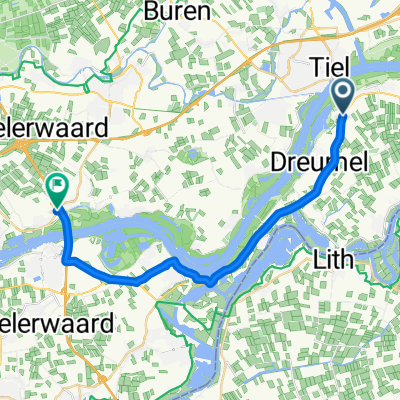
Tiel-Zaltbommel-Echteld-Tiel
A cycling route starting in Tiel, Gelderland, The Netherlands.
Overview
About this route
Waalbandijk-Zaltbommel-Echteld
- -:--
- Duration
- 61.1 km
- Distance
- 124 m
- Ascent
- 122 m
- Descent
- ---
- Avg. speed
- 17 m
- Max. altitude

Route quality
Waytypes & surfaces along the route
Waytypes
Quiet road
33 km
(54 %)
Cycleway
24.5 km
(40 %)
Surfaces
Paved
33.6 km
(55 %)
Asphalt
33.6 km
(55 %)
Undefined
27.5 km
(45 %)
Continue with Bikemap
Use, edit, or download this cycling route
You would like to ride Tiel-Zaltbommel-Echteld-Tiel or customize it for your own trip? Here is what you can do with this Bikemap route:
Free features
- Save this route as favorite or in collections
- Copy & plan your own version of this route
- Sync your route with Garmin or Wahoo
Premium features
Free trial for 3 days, or one-time payment. More about Bikemap Premium.
- Navigate this route on iOS & Android
- Export a GPX / KML file of this route
- Create your custom printout (try it for free)
- Download this route for offline navigation
Discover more Premium features.
Get Bikemap PremiumFrom our community
Other popular routes starting in Tiel
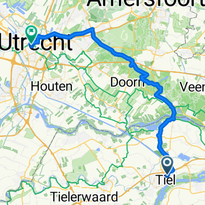
 Tiel - Utrechtse Heuvel Rug - Tiel
- Distance
- 65.1 km
- Ascent
- 201 m
- Descent
- 200 m
- Location
- Tiel, Gelderland, The Netherlands
 Tiel - Neerijnen
- Distance
- 19.3 km
- Ascent
- 10 m
- Descent
- 10 m
- Location
- Tiel, Gelderland, The Netherlands
 Unbenannte Route
- Distance
- 176.5 km
- Ascent
- 234 m
- Descent
- 235 m
- Location
- Tiel, Gelderland, The Netherlands
 Tiel - Neerijnen
- Distance
- 21.2 km
- Ascent
- 14 m
- Descent
- 13 m
- Location
- Tiel, Gelderland, The Netherlands
 Small route between rivers
- Distance
- 37 km
- Ascent
- 13 m
- Descent
- 12 m
- Location
- Tiel, Gelderland, The Netherlands
 Tiel-Wamel-Boven-Leeuwen-Beneden-Leeuwen
- Distance
- 22.7 km
- Ascent
- 19 m
- Descent
- 22 m
- Location
- Tiel, Gelderland, The Netherlands
 Hasi/Hermann2025
- Distance
- 187.1 km
- Ascent
- 233 m
- Descent
- 229 m
- Location
- Tiel, Gelderland, The Netherlands
 Hasi/Hermann2025 - 1
- Distance
- 52.6 km
- Ascent
- 187 m
- Descent
- 178 m
- Location
- Tiel, Gelderland, The Netherlands
Open it in the app