

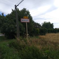
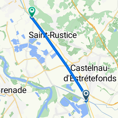
Eurocenter - Boluc
A cycling route starting in Castelnau-d’Estrétefonds, Occitanie, France.
Overview
About this route
- 1 h 2 min
- Duration
- 12.6 km
- Distance
- 192 m
- Ascent
- 180 m
- Descent
- 12.3 km/h
- Avg. speed
- ---
- Max. altitude

Route photos


Route quality
Waytypes & surfaces along the route
Waytypes
Road
9 km
(71 %)
Quiet road
2.8 km
(22 %)
Surfaces
Paved
11.1 km
(88 %)
Asphalt
11.1 km
(88 %)
Undefined
1.5 km
(12 %)
Continue with Bikemap
Use, edit, or download this cycling route
You would like to ride Eurocenter - Boluc or customize it for your own trip? Here is what you can do with this Bikemap route:
Free features
- Save this route as favorite or in collections
- Copy & plan your own version of this route
- Sync your route with Garmin or Wahoo
Premium features
Free trial for 3 days, or one-time payment. More about Bikemap Premium.
- Navigate this route on iOS & Android
- Export a GPX / KML file of this route
- Create your custom printout (try it for free)
- Download this route for offline navigation
Discover more Premium features.
Get Bikemap PremiumFrom our community
Other popular routes starting in Castelnau-d’Estrétefonds
 Rue de l'Église, Castelnau-d'Estrétefonds to Chemin d'Occitanie, Ayguesvives
- Distance
- 50.8 km
- Ascent
- 164 m
- Descent
- 100 m
- Location
- Castelnau-d’Estrétefonds, Occitanie, France
 Eurocenter - Boluc
- Distance
- 12.6 km
- Ascent
- 192 m
- Descent
- 180 m
- Location
- Castelnau-d’Estrétefonds, Occitanie, France
 Castelneau d'Estretefonds to Carcassonne
- Distance
- 120.4 km
- Ascent
- 160 m
- Descent
- 153 m
- Location
- Castelnau-d’Estrétefonds, Occitanie, France
 De 878 Route de Bouloc, Castelnau-d'Estrétefonds à 78 Avenue de Pontaillac, Royan
- Distance
- 350.4 km
- Ascent
- 1,652 m
- Descent
- 1,842 m
- Location
- Castelnau-d’Estrétefonds, Occitanie, France
 Relaxed route in Pompignan
- Distance
- 6.9 km
- Ascent
- 3 m
- Descent
- 9 m
- Location
- Castelnau-d’Estrétefonds, Occitanie, France
 Circuit du chemin Leonard
- Distance
- 4.1 km
- Ascent
- 89 m
- Descent
- 86 m
- Location
- Castelnau-d’Estrétefonds, Occitanie, France
 De Le Moulin, Castelnau-d'Estrétefonds à Rond-Point Henri Dunant, Tournefeuille
- Distance
- 26.9 km
- Ascent
- 91 m
- Descent
- 52 m
- Location
- Castelnau-d’Estrétefonds, Occitanie, France
 C2M - Castelnau d'estrétefonds - Montech
- Distance
- 23.4 km
- Ascent
- 13 m
- Descent
- 17 m
- Location
- Castelnau-d’Estrétefonds, Occitanie, France
Open it in the app