

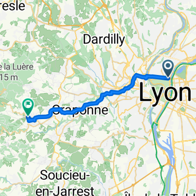
Lyon - Vaugneray
A cycling route starting in Caluire-et-Cuire, Auvergne-Rhône-Alpes, France.
Overview
About this route
- -:--
- Duration
- 17.9 km
- Distance
- 372 m
- Ascent
- 176 m
- Descent
- ---
- Avg. speed
- ---
- Max. altitude

Route quality
Waytypes & surfaces along the route
Waytypes
Quiet road
8.5 km
(48 %)
Road
4.5 km
(25 %)
Surfaces
Paved
13.2 km
(74 %)
Unpaved
0.3 km
(2 %)
Asphalt
13.1 km
(73 %)
Gravel
0.3 km
(2 %)
Continue with Bikemap
Use, edit, or download this cycling route
You would like to ride Lyon - Vaugneray or customize it for your own trip? Here is what you can do with this Bikemap route:
Free features
- Save this route as favorite or in collections
- Copy & plan your own version of this route
- Sync your route with Garmin or Wahoo
Premium features
Free trial for 3 days, or one-time payment. More about Bikemap Premium.
- Navigate this route on iOS & Android
- Export a GPX / KML file of this route
- Create your custom printout (try it for free)
- Download this route for offline navigation
Discover more Premium features.
Get Bikemap PremiumFrom our community
Other popular routes starting in Caluire-et-Cuire
 Lyon - Vaugneray
- Distance
- 17.9 km
- Ascent
- 372 m
- Descent
- 176 m
- Location
- Caluire-et-Cuire, Auvergne-Rhône-Alpes, France
 Quick bike tour from Villeurbanne to Lyon
- Distance
- 6.3 km
- Ascent
- 55 m
- Descent
- 46 m
- Location
- Caluire-et-Cuire, Auvergne-Rhône-Alpes, France
 La petite virée des deux lacs (30km)
- Distance
- 29.4 km
- Ascent
- 37 m
- Descent
- 39 m
- Location
- Caluire-et-Cuire, Auvergne-Rhône-Alpes, France
 2 Des bords de Saône aux Monts D'Or
- Distance
- 36.8 km
- Ascent
- 682 m
- Descent
- 661 m
- Location
- Caluire-et-Cuire, Auvergne-Rhône-Alpes, France
 entrainement 2
- Distance
- 145.3 km
- Ascent
- 1,998 m
- Descent
- 2,000 m
- Location
- Caluire-et-Cuire, Auvergne-Rhône-Alpes, France
 a5 Grand tour de l'ouest lyonnais
- Distance
- 125.5 km
- Ascent
- 2,012 m
- Descent
- 2,014 m
- Location
- Caluire-et-Cuire, Auvergne-Rhône-Alpes, France
 tour de Mt d'Or
- Distance
- 41.4 km
- Ascent
- 1,072 m
- Descent
- 1,072 m
- Location
- Caluire-et-Cuire, Auvergne-Rhône-Alpes, France
 La Dombes à partir de Caluire
- Distance
- 69.6 km
- Ascent
- 249 m
- Descent
- 238 m
- Location
- Caluire-et-Cuire, Auvergne-Rhône-Alpes, France
Open it in the app