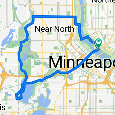
B2B00309 55401>55101 via University Av, Transitway, Como Ave
A cycling route starting in Minneapolis, Minnesota, United States of America.
Overview
About this route
At the end of 1st St N, there is a ramp you can take to get to the Stone Arch Bridge.
<br />Will need to take 4th St SE on the return trip as University is a one-way street.
- -:--
- Duration
- 17.7 km
- Distance
- 106 m
- Ascent
- 105 m
- Descent
- ---
- Avg. speed
- ---
- Avg. speed
Route quality
Waytypes & surfaces along the route
Waytypes
Undefined
17.7 km
(100 %)
Surfaces
Undefined
17.7 km
(100 %)
Route highlights
Points of interest along the route
Point of interest after 1.4 km
There is a ramp here you can take to get to the Stone Arch Bridge.
Continue with Bikemap
Use, edit, or download this cycling route
You would like to ride B2B00309 55401>55101 via University Av, Transitway, Como Ave or customize it for your own trip? Here is what you can do with this Bikemap route:
Free features
- Save this route as favorite or in collections
- Copy & plan your own version of this route
- Sync your route with Garmin or Wahoo
Premium features
Free trial for 3 days, or one-time payment. More about Bikemap Premium.
- Navigate this route on iOS & Android
- Export a GPX / KML file of this route
- Create your custom printout (try it for free)
- Download this route for offline navigation
Discover more Premium features.
Get Bikemap PremiumFrom our community
Other popular routes starting in Minneapolis
- 1500–1562 Spruce Pl, Minneapolis to 1512 Spruce Pl, Minneapolis
- Distance
- 28.4 km
- Ascent
- 133 m
- Descent
- 132 m
- Location
- Minneapolis, Minnesota, United States of America
- 1512 Spruce Pl, Minneapolis to 1512 Spruce Pl, Minneapolis
- Distance
- 27.3 km
- Ascent
- 123 m
- Descent
- 123 m
- Location
- Minneapolis, Minnesota, United States of America
- 30 Miles
- Distance
- 46.5 km
- Ascent
- 122 m
- Descent
- 142 m
- Location
- Minneapolis, Minnesota, United States of America
- S Sixth St, Minneapolis to Spruce Pl, Minneapolis
- Distance
- 1.7 km
- Ascent
- 6 m
- Descent
- 21 m
- Location
- Minneapolis, Minnesota, United States of America
- TCAC Cedar Lake Loop
- Distance
- 15.9 km
- Ascent
- 55 m
- Descent
- 54 m
- Location
- Minneapolis, Minnesota, United States of America
- Out to Minnetonka and back
- Distance
- 52 km
- Ascent
- 265 m
- Descent
- 264 m
- Location
- Minneapolis, Minnesota, United States of America
- 1512 Spruce Pl, Minneapolis to 312 Central Ave SE, Minneapolis
- Distance
- 27.4 km
- Ascent
- 147 m
- Descent
- 142 m
- Location
- Minneapolis, Minnesota, United States of America
- 34 Spruce Pl, Minneapolis to Loring Park, Minneapolis
- Distance
- 15.3 km
- Ascent
- 62 m
- Descent
- 63 m
- Location
- Minneapolis, Minnesota, United States of America