Sladem starozytnych Rzymian
- 19.8 km
- 881 m
- 888 m
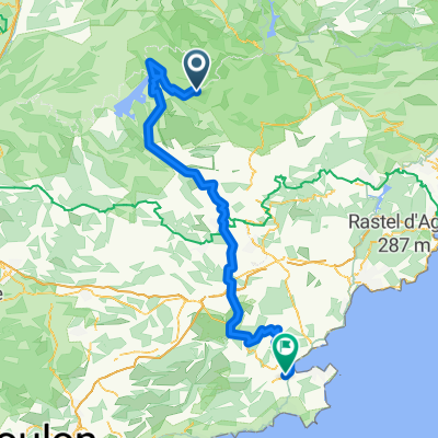
- Castellane, Provence-Alpes-Côte d'Azur Region, France
A cycling route starting in Castellane, Provence-Alpes-Côte d'Azur Region, France.
Overview
Der Grand Canyon Verdon. Die größte und eindruckvollste Schlucht Europas. Ein Klassiker. Ein Geheimtipp. Was erwartet uns? ca. 100 KM und über 2000 HM. Eine atemberaubende Landschaft mit fazinierenden Blicke in die Verdon Schlucht. Im Canyon sind einige Pässe zu überwinden. Der Col d` Ayen oder der Collet Barris, wo es von 500 HM auf 1400 HM hochgeht. Steigungen bis 14 %. Aber diese Tour und diese Eindrücke sind unvergesslich. Blicke zum Stausee, ein auf und ab mit schmalen Straßen direkt am Canyon. Diese Tour ist der Höhepunkt für jeden Biker.
Start und Ziel in Les Salies sur Verdon am Camping. Umrundung der Schlucht im Uhrzeigersinn. 115 KM, 2500 HM - Atemberaubend und zählt zu den schönsten Bikerouten der Welt. detailierte Beschreibung unter www.alpenheld.de
created this 6 years ago
Route quality
Road
17.3 km
(14 %)
Track
9.9 km
(8 %)
Paved
107.7 km
(87 %)
Unpaved
8.7 km
(7 %)
Asphalt
107.7 km
(87 %)
Unpaved (undefined)
5 km
(4 %)
Continue with Bikemap
You would like to ride Grand Canyon Verdon Umrundung or customize it for your own trip? Here is what you can do with this Bikemap route:
Free trial for 3 days, or one-time payment. More about Bikemap Premium.
Discover more Premium features.
Get Bikemap PremiumFrom our community
Open it in the app