

Kozlany - okruh no. 1
A cycling route starting in Kožlany, Plzeň Region, Czechia.
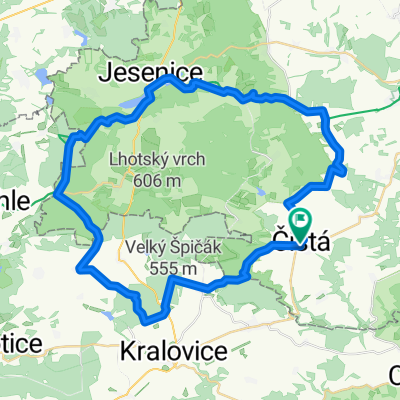
Overview
About this route
Relaxed afternoon ride with departure to Saint Hubert. The route is of moderate difficulty. Rideable on a cross bike.
- -:--
- Duration
- 39 km
- Distance
- 495 m
- Ascent
- 484 m
- Descent
- ---
- Avg. speed
- 599 m
- Max. altitude

Route quality
Waytypes & surfaces along the route
Waytypes
Track
15.2 km
(39 %)
Road
10.5 km
(27 %)
Surfaces
Paved
6.2 km
(16 %)
Unpaved
15.2 km
(39 %)
Gravel
11.7 km
(30 %)
Asphalt
5.5 km
(14 %)
Continue with Bikemap
Use, edit, or download this cycling route
You would like to ride Kozlany - okruh no. 1 or customize it for your own trip? Here is what you can do with this Bikemap route:
Free features
- Save this route as favorite or in collections
- Copy & plan your own version of this route
- Sync your route with Garmin or Wahoo
Premium features
Free trial for 3 days, or one-time payment. More about Bikemap Premium.
- Navigate this route on iOS & Android
- Export a GPX / KML file of this route
- Create your custom printout (try it for free)
- Download this route for offline navigation
Discover more Premium features.
Get Bikemap PremiumFrom our community
Other popular routes starting in Kožlany
 Kožlany - Rakovník
- Distance
- 27.9 km
- Ascent
- 298 m
- Descent
- 418 m
- Location
- Kožlany, Plzeň Region, Czechia
 17.BRODY-Krakovec-Zvíkovec-Chříč-Uhrovic mlýn-Krakovec
- Distance
- 27.4 km
- Ascent
- 293 m
- Descent
- 293 m
- Location
- Kožlany, Plzeň Region, Czechia
 Kozlany - okruh no.2
- Distance
- 41.6 km
- Ascent
- 515 m
- Descent
- 445 m
- Location
- Kožlany, Plzeň Region, Czechia
 Domů
Domů- Distance
- 91.6 km
- Ascent
- 731 m
- Descent
- 870 m
- Location
- Kožlany, Plzeň Region, Czechia
 Bike 2014-Zdeslav-Rakovník-Louny-Teplice
- Distance
- 109.1 km
- Ascent
- 664 m
- Descent
- 926 m
- Location
- Kožlany, Plzeň Region, Czechia
 Jen tak po okolí Jesenice
- Distance
- 46.4 km
- Ascent
- 663 m
- Descent
- 653 m
- Location
- Kožlany, Plzeň Region, Czechia
 2013-06-29 Ztracené kobylky
- Distance
- 61 km
- Ascent
- 680 m
- Descent
- 681 m
- Location
- Kožlany, Plzeň Region, Czechia
 Ztracené kobylky 2103
- Distance
- 43.7 km
- Ascent
- 459 m
- Descent
- 459 m
- Location
- Kožlany, Plzeň Region, Czechia
Open it in the app