Pfingstmontag
A cycling route starting in Ingelheim, Rhineland-Palatinate, Germany.
Overview
About this route
Start- & Zielort: Hans & Eva
Ingelheim - A60 entlang nach Heidesheim - Friedhof -rechts abbiegen und unter Eisenbahnunterführung durch - Links abbiegen und am Ende rechts hoch bis Hauptstrasse - Links nach Budenheim - Waldhausen hoch - Finthen - Mainz Drais - Lerchenberg - Ober Olm - Klein Winternheim - Nieder Olm - Stadecken Elsheim - Schwabenheim - Großwinternheim - Ingelheim.
- -:--
- Duration
- 45.6 km
- Distance
- 230 m
- Ascent
- 233 m
- Descent
- ---
- Avg. speed
- ---
- Max. altitude
Route quality
Waytypes & surfaces along the route
Waytypes
Busy road
17.6 km
(39 %)
Quiet road
7.5 km
(16 %)
Surfaces
Paved
40.1 km
(88 %)
Unpaved
1.1 km
(2 %)
Asphalt
35.1 km
(77 %)
Paving stones
3.7 km
(8 %)
Continue with Bikemap
Use, edit, or download this cycling route
You would like to ride Pfingstmontag or customize it for your own trip? Here is what you can do with this Bikemap route:
Free features
- Save this route as favorite or in collections
- Copy & plan your own version of this route
- Sync your route with Garmin or Wahoo
Premium features
Free trial for 3 days, or one-time payment. More about Bikemap Premium.
- Navigate this route on iOS & Android
- Export a GPX / KML file of this route
- Create your custom printout (try it for free)
- Download this route for offline navigation
Discover more Premium features.
Get Bikemap PremiumFrom our community
Other popular routes starting in Ingelheim
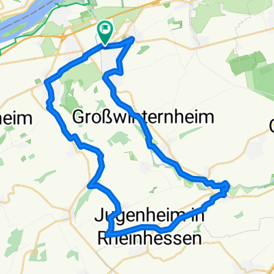
- große Hunsrücktour II Ingelheim, Gemünden, Ingelheim (Variante)
- Distance
- 119.7 km
- Ascent
- 1,586 m
- Descent
- 1,533 m
- Location
- Ingelheim, Rhineland-Palatinate, Germany
- Ingelheim - Guldental - Wallhausen - Mandel - Waldböckelheim - Odernheim - Bad Münster - Fürfeld - Sprendlingen - Ingelheim
- Distance
- 118.1 km
- Ascent
- 878 m
- Descent
- 876 m
- Location
- Ingelheim, Rhineland-Palatinate, Germany
- Ingelh-Walgalgesh-Windesh-Ingelh 3
- Distance
- 53 km
- Ascent
- 328 m
- Descent
- 327 m
- Location
- Ingelheim, Rhineland-Palatinate, Germany
- 32_Ingelheim – Jugenheim – Schwabenheim – Ingelheim
- Distance
- 35.6 km
- Ascent
- 262 m
- Descent
- 262 m
- Location
- Ingelheim, Rhineland-Palatinate, Germany
- "Üwwer die Schiersteiner Brück!"
- Distance
- 39.5 km
- Ascent
- 55 m
- Descent
- 55 m
- Location
- Ingelheim, Rhineland-Palatinate, Germany
- 011u Ingelheim - Wendelsheim - Pfaffen Schwabenheim - Ingelheim
- Distance
- 66.6 km
- Ascent
- 374 m
- Descent
- 308 m
- Location
- Ingelheim, Rhineland-Palatinate, Germany
- 016d Ingelheim - Presberg - Bacharach - Rheinböllen - Stromberg - Ingelheim
- Distance
- 89.2 km
- Ascent
- 1,274 m
- Descent
- 1,258 m
- Location
- Ingelheim, Rhineland-Palatinate, Germany
- Zur Rausch 5
- Distance
- 18 km
- Ascent
- 241 m
- Descent
- 176 m
- Location
- Ingelheim, Rhineland-Palatinate, Germany
Open it in the app