

Mal im Flachen
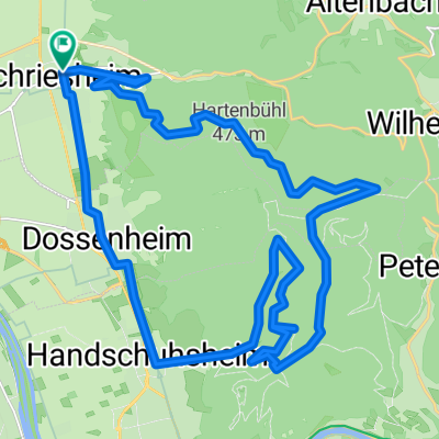
A cycling route starting in Schriesheim, Baden-Wurttemberg, Germany.
Overview
About this route
- -:--
- Duration
- 75.1 km
- Distance
- 772 m
- Ascent
- 772 m
- Descent
- ---
- Avg. speed
- ---
- Max. altitude
Route quality
Waytypes & surfaces along the route
Waytypes
Road
12.8 km
(17 %)
Quiet road
6 km
(8 %)
Surfaces
Paved
64.6 km
(86 %)
Unpaved
3 km
(4 %)
Asphalt
64.6 km
(86 %)
Gravel
3 km
(4 %)
Undefined
7.5 km
(10 %)
Continue with Bikemap
Use, edit, or download this cycling route
You would like to ride Mal im Flachen or customize it for your own trip? Here is what you can do with this Bikemap route:
Free features
- Save this route as favorite or in collections
- Copy & plan your own version of this route
- Sync your route with Garmin or Wahoo
Premium features
Free trial for 3 days, or one-time payment. More about Bikemap Premium.
- Navigate this route on iOS & Android
- Export a GPX / KML file of this route
- Create your custom printout (try it for free)
- Download this route for offline navigation
Discover more Premium features.
Get Bikemap PremiumFrom our community
Other popular routes starting in Schriesheim
 HD Heiligenberg + Königsstuhl
- Distance
- 52.1 km
- Ascent
- 1,219 m
- Descent
- 1,226 m
- Location
- Schriesheim, Baden-Wurttemberg, Germany
 Höhenrundfahrt Hirschberg
- Distance
- 16.6 km
- Ascent
- 377 m
- Descent
- 406 m
- Location
- Schriesheim, Baden-Wurttemberg, Germany
 Rhein-Neckar-Rundfahrt (kurz)
- Distance
- 28.7 km
- Ascent
- 29 m
- Descent
- 31 m
- Location
- Schriesheim, Baden-Wurttemberg, Germany
 Schriesheim-Gorxheim_Rundtour
- Distance
- 31.7 km
- Ascent
- 629 m
- Descent
- 627 m
- Location
- Schriesheim, Baden-Wurttemberg, Germany
 Minigolf-Runde
- Distance
- 19 km
- Ascent
- 26 m
- Descent
- 29 m
- Location
- Schriesheim, Baden-Wurttemberg, Germany
 Höhenrundfahrt Hirschberg-Ursenbach-Oberflockenbach-Hirschberg
- Distance
- 14.9 km
- Ascent
- 34 m
- Descent
- 38 m
- Location
- Schriesheim, Baden-Wurttemberg, Germany
 Schriesheim - Weißer Stein
- Distance
- 28.7 km
- Ascent
- 656 m
- Descent
- 657 m
- Location
- Schriesheim, Baden-Wurttemberg, Germany
 Freitag 7. April 2017
- Distance
- 36.5 km
- Ascent
- 609 m
- Descent
- 612 m
- Location
- Schriesheim, Baden-Wurttemberg, Germany
Open it in the app