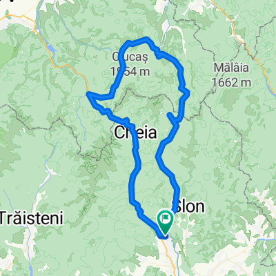
Maneciu-Vf lui Crai-Ciucas-Poiana Stanii-Izvoarele
A cycling route starting in Măneciu-Ungureni, Prahova, Romania.
Overview
About this route
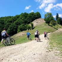
Traseul este foarte frumos, teoretic traseul era propus pana la km 26, intersectia cu drumul spre poiana stanii si banda rosie spre Ciucas. Am ajuns mai repede decat speram si am pornit la vale paralel cu Raul Buzau, pe urma a fost o urcare uratica, 2 ore de pushbike pana la intersectia banda rosie si banda albastra ce merge spre Vf Ciucas. Recomand sa mergeti pana la km 26 si sa coborati spre baraj.
Spor la pedalat.
- -:--
- Duration
- 74 km
- Distance
- 1,574 m
- Ascent
- 1,642 m
- Descent
- ---
- Avg. speed
- ---
- Avg. speed
Route photos
Route quality
Waytypes & surfaces along the route
Waytypes
Track
39.4 km
(53 %)
Quiet road
24.6 km
(33 %)
Surfaces
Paved
9 km
(12 %)
Unpaved
52.8 km
(71 %)
Loose gravel
28.2 km
(38 %)
Ground
20.6 km
(28 %)
Route highlights
Points of interest along the route
Point of interest after 38.4 km
Intersectie banda rosie cu banda albastra spre Vf Ciucas
Continue with Bikemap
Use, edit, or download this cycling route
You would like to ride Maneciu-Vf lui Crai-Ciucas-Poiana Stanii-Izvoarele or customize it for your own trip? Here is what you can do with this Bikemap route:
Free features
- Save this route as favorite or in collections
- Copy & plan your own version of this route
- Sync your route with Garmin or Wahoo
Premium features
Free trial for 3 days, or one-time payment. More about Bikemap Premium.
- Navigate this route on iOS & Android
- Export a GPX / KML file of this route
- Create your custom printout (try it for free)
- Download this route for offline navigation
Discover more Premium features.
Get Bikemap PremiumFrom our community
Other popular routes starting in Măneciu-Ungureni
- Cheia MTB Challenge 2014
- Distance
- 49.8 km
- Ascent
- 1,121 m
- Descent
- 1,121 m
- Location
- Măneciu-Ungureni, Prahova, Romania
- Grohotis - Ciucas
- Distance
- 90 km
- Ascent
- 2,031 m
- Descent
- 2,031 m
- Location
- Măneciu-Ungureni, Prahova, Romania
- Maneciu-lacul Vulturilor-Crasna
- Distance
- 50.1 km
- Ascent
- 1,302 m
- Descent
- 1,209 m
- Location
- Măneciu-Ungureni, Prahova, Romania
- Traseul Muntilor Tataru
- Distance
- 47.6 km
- Ascent
- 1,168 m
- Descent
- 926 m
- Location
- Măneciu-Ungureni, Prahova, Romania
- Tura maneciu
- Distance
- 51.9 km
- Ascent
- 0 m
- Descent
- 0 m
- Location
- Măneciu-Ungureni, Prahova, Romania
- eMTB Maneciu-Slon-Tabla Butii-Cascada Schinda
- Distance
- 55.7 km
- Ascent
- 1,669 m
- Descent
- 1,655 m
- Location
- Măneciu-Ungureni, Prahova, Romania
- Maneciu - Pasul Boncuta - Maneciu CLONED FROM ROUTE 63456
- Distance
- 35.1 km
- Ascent
- 595 m
- Descent
- 587 m
- Location
- Măneciu-Ungureni, Prahova, Romania
- Creasta Muntilor Tataru
- Distance
- 49.1 km
- Ascent
- 1,095 m
- Descent
- 1,090 m
- Location
- Măneciu-Ungureni, Prahova, Romania
Open it in the app