

Overview
About this route
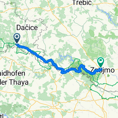
Slavonice, Weißkirchen,Dobersberg, Waidhofen, Windigsteig, Göpfritz
- -:--
- Duration
- 50.1 km
- Distance
- 238 m
- Ascent
- 182 m
- Descent
- ---
- Avg. speed
- ---
- Max. altitude

Part of

Thayarunde
2 stages
Route quality
Waytypes & surfaces along the route
Waytypes
Cycleway
27.6 km
(55 %)
Quiet road
9.1 km
(18 %)
Surfaces
Paved
45.7 km
(91 %)
Asphalt
45.2 km
(90 %)
Paved (undefined)
0.5 km
(<1 %)
Continue with Bikemap
Use, edit, or download this cycling route
You would like to ride Slavonice - Göpfritz or customize it for your own trip? Here is what you can do with this Bikemap route:
Free features
- Save this route as favorite or in collections
- Copy & plan your own version of this route
- Sync your route with Garmin or Wahoo
Premium features
Free trial for 3 days, or one-time payment. More about Bikemap Premium.
- Navigate this route on iOS & Android
- Export a GPX / KML file of this route
- Create your custom printout (try it for free)
- Download this route for offline navigation
Discover more Premium features.
Get Bikemap PremiumFrom our community
Other popular routes starting in Slavonice
 Prague - Brno, Euro Velo No 7, 13, 9 and 4! Etapp 3
- Distance
- 75.9 km
- Ascent
- 937 m
- Descent
- 1,144 m
- Location
- Slavonice, Jihočeský kraj, Czechia
 Českou Kanadou 1/2 dne
- Distance
- 50 km
- Ascent
- 641 m
- Descent
- 633 m
- Location
- Slavonice, Jihočeský kraj, Czechia
 Trasa Cizkrajov - Český Rudolec - Landštejn - Slavonice - Cizkrajov
- Distance
- 49.5 km
- Ascent
- 548 m
- Descent
- 548 m
- Location
- Slavonice, Jihočeský kraj, Czechia
 MTB Landštejn 2011
- Distance
- 55.3 km
- Ascent
- 580 m
- Descent
- 576 m
- Location
- Slavonice, Jihočeský kraj, Czechia
 Slavonice-Dacice-Telc-Slavonice
- Distance
- 58.7 km
- Ascent
- 494 m
- Descent
- 495 m
- Location
- Slavonice, Jihočeský kraj, Czechia
 MORAVA-11.den-25.7.13
- Distance
- 63.1 km
- Ascent
- 431 m
- Descent
- 486 m
- Location
- Slavonice, Jihočeský kraj, Czechia
 Greenways Praha - Vídeň IV.
- Distance
- 149.6 km
- Ascent
- 565 m
- Descent
- 829 m
- Location
- Slavonice, Jihočeský kraj, Czechia
 Slavonice - Trojmezi
- Distance
- 15.1 km
- Ascent
- 220 m
- Descent
- 223 m
- Location
- Slavonice, Jihočeský kraj, Czechia
Open it in the app