

Thalham-Sachsenkam über Taubenberg
A cycling route starting in Weyarn, Bavaria, Germany.
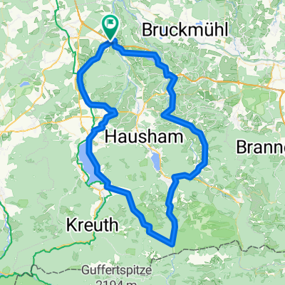
Overview
About this route
- -:--
- Duration
- 37.6 km
- Distance
- 393 m
- Ascent
- 430 m
- Descent
- ---
- Avg. speed
- ---
- Max. altitude
Route quality
Waytypes & surfaces along the route
Waytypes
Quiet road
17.7 km
(47 %)
Track
10.5 km
(28 %)
Surfaces
Paved
27.4 km
(73 %)
Unpaved
8.6 km
(23 %)
Asphalt
27.4 km
(73 %)
Gravel
6 km
(16 %)
Continue with Bikemap
Use, edit, or download this cycling route
You would like to ride Thalham-Sachsenkam über Taubenberg or customize it for your own trip? Here is what you can do with this Bikemap route:
Free features
- Save this route as favorite or in collections
- Copy & plan your own version of this route
- Sync your route with Garmin or Wahoo
Premium features
Free trial for 3 days, or one-time payment. More about Bikemap Premium.
- Navigate this route on iOS & Android
- Export a GPX / KML file of this route
- Create your custom printout (try it for free)
- Download this route for offline navigation
Discover more Premium features.
Get Bikemap PremiumFrom our community
Other popular routes starting in Weyarn
 Irschenberg-Tegernsee-Valepp-Elbach-Niklaskreuth
- Distance
- 109.5 km
- Ascent
- 1,027 m
- Descent
- 1,025 m
- Location
- Weyarn, Bavaria, Germany
 Mitterdarching - Valepp
- Distance
- 89.6 km
- Ascent
- 876 m
- Descent
- 879 m
- Location
- Weyarn, Bavaria, Germany
 Miesbach - Tegernsee - Spitzingsee - Miesbach
- Distance
- 84.3 km
- Ascent
- 935 m
- Descent
- 935 m
- Location
- Weyarn, Bavaria, Germany
 Weyern-Seehamersee
- Distance
- 21.8 km
- Ascent
- 286 m
- Descent
- 289 m
- Location
- Weyarn, Bavaria, Germany
 Brucker Straße 2, Weyarn nach Holzkirchner Straße 12, Sachsenkam
- Distance
- 30.6 km
- Ascent
- 411 m
- Descent
- 345 m
- Location
- Weyarn, Bavaria, Germany
 Taubenberg Seehamersee Runde
- Distance
- 33.3 km
- Ascent
- 527 m
- Descent
- 527 m
- Location
- Weyarn, Bavaria, Germany
 Mühlthal, Valley nach Schliersee
- Distance
- 22.7 km
- Ascent
- 3,302 m
- Descent
- 3,124 m
- Location
- Weyarn, Bavaria, Germany
 MTB-Taubenberg-Seehamersee-33km
- Distance
- 33.3 km
- Ascent
- 528 m
- Descent
- 528 m
- Location
- Weyarn, Bavaria, Germany
Open it in the app