
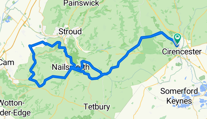
3 Hours of Cotswolds Hills June 10
A cycling route starting in Cirencester, England, United Kingdom.
Overview
About this route
- -:--
- Duration
- 73.8 km
- Distance
- 836 m
- Ascent
- 832 m
- Descent
- ---
- Avg. speed
- ---
- Max. altitude

Route quality
Waytypes & surfaces along the route
Waytypes
Quiet road
46.5 km
(63 %)
Road
11.8 km
(16 %)
Surfaces
Paved
28.8 km
(39 %)
Asphalt
28.8 km
(39 %)
Undefined
45 km
(61 %)
Route highlights
Points of interest along the route
Point of interest after 0.9 km
Withington Climb
Point of interest after 0.9 km
Abdale Climb south
Point of interest after 3.7 km
Hilcot climb
Point of interest after 9.9 km
Point of interest after 23.7 km
The W
Point of interest after 25.9 km
Amberley Climb
Point of interest after 27.8 km
Woodchester climb
Point of interest after 28.9 km
Selsley
Point of interest after 36.4 km
Frocester climb
Point of interest after 39.2 km
Uley Climb
Point of interest after 41.9 km
Uley / Owlpen climb
Point of interest after 48 km
Horsley Climb
Point of interest after 53.3 km
Slad climb
Point of interest after 54.7 km
Point of interest after 66.5 km
St Leonards climb
Continue with Bikemap
Use, edit, or download this cycling route
You would like to ride 3 Hours of Cotswolds Hills June 10 or customize it for your own trip? Here is what you can do with this Bikemap route:
Free features
- Save this route as favorite or in collections
- Copy & plan your own version of this route
- Sync your route with Garmin or Wahoo
Premium features
Free trial for 3 days, or one-time payment. More about Bikemap Premium.
- Navigate this route on iOS & Android
- Export a GPX / KML file of this route
- Create your custom printout (try it for free)
- Download this route for offline navigation
Discover more Premium features.
Get Bikemap PremiumFrom our community
Other popular routes starting in Cirencester
 cotswolds
- Distance
- 31.7 km
- Ascent
- 227 m
- Descent
- 321 m
- Location
- Cirencester, England, United Kingdom
 Easy loop, Ciren-Oaksey-Minety
- Distance
- 51.1 km
- Ascent
- 105 m
- Descent
- 105 m
- Location
- Cirencester, England, United Kingdom
 Ciren. N.E. - Figure of 8 Hills
- Distance
- 56.3 km
- Ascent
- 775 m
- Descent
- 729 m
- Location
- Cirencester, England, United Kingdom
 3 Hours of Cotswolds Hills June 10
- Distance
- 73.8 km
- Ascent
- 836 m
- Descent
- 832 m
- Location
- Cirencester, England, United Kingdom
 Ciren-withington-brockhmpton-salprtn fig 8
- Distance
- 47.7 km
- Ascent
- 478 m
- Descent
- 446 m
- Location
- Cirencester, England, United Kingdom
 Cotswold 100km
- Distance
- 97.7 km
- Ascent
- 693 m
- Descent
- 692 m
- Location
- Cirencester, England, United Kingdom
 Cirencester - Bristol (Severn)
- Distance
- 106.3 km
- Ascent
- 348 m
- Descent
- 446 m
- Location
- Cirencester, England, United Kingdom
 Cirencester to Stow-on-the-Wold
- Distance
- 37.7 km
- Ascent
- 433 m
- Descent
- 315 m
- Location
- Cirencester, England, United Kingdom
Open it in the app