

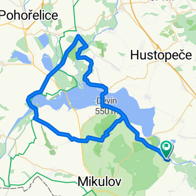
Bulhary- Iváň -Pasohlávky - Bulhary
A cycling route starting in Zaječí, South Moravian, Czechia.
Overview
About this route
Čím více zde napíšete informací, tím více bude užitečnější pro ostatním uživatele.<br /><br />* Průběh trasy.<br />* Co je zvláštní na této trase?<br />* Proč doporučit tuto trasu?<br />* Co se Vám zde nejvíce líbilo?<br />* Atd.
- -:--
- Duration
- 58.3 km
- Distance
- 267 m
- Ascent
- 264 m
- Descent
- ---
- Avg. speed
- ---
- Max. altitude
Route quality
Waytypes & surfaces along the route
Waytypes
Road
40.2 km
(69 %)
Track
10.5 km
(18 %)
Surfaces
Paved
39.1 km
(67 %)
Unpaved
7.6 km
(13 %)
Asphalt
39.1 km
(67 %)
Unpaved (undefined)
5.8 km
(10 %)
Route highlights
Points of interest along the route

Point of interest after 10.8 km
Archeologické muzeum-Dolní Věstonice
Continue with Bikemap
Use, edit, or download this cycling route
You would like to ride Bulhary- Iváň -Pasohlávky - Bulhary or customize it for your own trip? Here is what you can do with this Bikemap route:
Free features
- Save this route as favorite or in collections
- Copy & plan your own version of this route
- Sync your route with Garmin or Wahoo
Premium features
Free trial for 3 days, or one-time payment. More about Bikemap Premium.
- Navigate this route on iOS & Android
- Export a GPX / KML file of this route
- Create your custom printout (try it for free)
- Download this route for offline navigation
Discover more Premium features.
Get Bikemap PremiumFrom our community
Other popular routes starting in Zaječí
 Putování po Modrých horách
- Distance
- 48.7 km
- Ascent
- 510 m
- Descent
- 510 m
- Location
- Zaječí, South Moravian, Czechia
 Moravské vinařské stezky 2018 - Májové putování okolím Modrých hor
- Distance
- 100.6 km
- Ascent
- 622 m
- Descent
- 593 m
- Location
- Zaječí, South Moravian, Czechia
 Zaječí - Nové Mlýny - Zaječí
- Distance
- 56.3 km
- Ascent
- 240 m
- Descent
- 240 m
- Location
- Zaječí, South Moravian, Czechia
 Zaječí do Vinařská
- Distance
- 81.9 km
- Ascent
- 498 m
- Descent
- 541 m
- Location
- Zaječí, South Moravian, Czechia
 Vinařská do Vinařská
- Distance
- 59.6 km
- Ascent
- 497 m
- Descent
- 548 m
- Location
- Zaječí, South Moravian, Czechia
 Přítluky - mandlový sad 2017
- Distance
- 41.9 km
- Ascent
- 483 m
- Descent
- 483 m
- Location
- Zaječí, South Moravian, Czechia
 Palava 04
- Distance
- 54.7 km
- Ascent
- 317 m
- Descent
- 314 m
- Location
- Zaječí, South Moravian, Czechia
 Bulhary- Iváň -Pasohlávky - Bulhary
- Distance
- 58.3 km
- Ascent
- 267 m
- Descent
- 264 m
- Location
- Zaječí, South Moravian, Czechia
Open it in the app