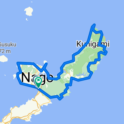
2019.11.22-24 極星車隊 北Okinawa 騎旅
A cycling route starting in Nago, Okinawa, Japan.
Overview
About this route
- -:--
- Duration
- 216.6 km
- Distance
- 1,361 m
- Ascent
- 1,356 m
- Descent
- ---
- Avg. speed
- ---
- Avg. speed
Route quality
Waytypes & surfaces along the route
Waytypes
Quiet road
100.2 km
(46 %)
Road
43.2 km
(20 %)
Surfaces
Paved
108.6 km
(50 %)
Unpaved
0.2 km
(<1 %)
Asphalt
86 km
(40 %)
Paved (undefined)
22.1 km
(10 %)
Continue with Bikemap
Use, edit, or download this cycling route
You would like to ride 2019.11.22-24 極星車隊 北Okinawa 騎旅 or customize it for your own trip? Here is what you can do with this Bikemap route:
Free features
- Save this route as favorite or in collections
- Copy & plan your own version of this route
- Sync your route with Garmin or Wahoo
Premium features
Free trial for 3 days, or one-time payment. More about Bikemap Premium.
- Navigate this route on iOS & Android
- Export a GPX / KML file of this route
- Create your custom printout (try it for free)
- Download this route for offline navigation
Discover more Premium features.
Get Bikemap PremiumFrom our community
Other popular routes starting in Nago
- 2015.07.09-13沖繩環島五天四夜
- Distance
- 340.3 km
- Ascent
- 860 m
- Descent
- 866 m
- Location
- Nago, Okinawa, Japan
- 2012環沖繩自行車大賽323KM挑戰賽
- Distance
- 343.3 km
- Ascent
- 854 m
- Descent
- 853 m
- Location
- Nago, Okinawa, Japan
- 沖繩環島 Day 4
- Distance
- 80.8 km
- Ascent
- 1,022 m
- Descent
- 1,087 m
- Location
- Nago, Okinawa, Japan
- 沖繩環島 Day 5
- Distance
- 63.3 km
- Ascent
- 1,007 m
- Descent
- 968 m
- Location
- Nago, Okinawa, Japan
- 2019.11.22-24 極星車隊 北Okinawa 騎旅
- Distance
- 216.6 km
- Ascent
- 1,361 m
- Descent
- 1,356 m
- Location
- Nago, Okinawa, Japan
- 環沖繩 - 2
- Distance
- 183.4 km
- Ascent
- 961 m
- Descent
- 950 m
- Location
- Nago, Okinawa, Japan
- 2015.078.01 Okinawa Day2
- Distance
- 81.1 km
- Ascent
- 303 m
- Descent
- 305 m
- Location
- Nago, Okinawa, Japan
- Okinawa Bike Day2
- Distance
- 71.5 km
- Ascent
- 430 m
- Descent
- 436 m
- Location
- Nago, Okinawa, Japan