

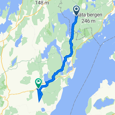
Bäggekärr - Lekhyttan
A cycling route starting in Anderstorp, Västra Götaland County, Sweden.
Overview
About this route
Stage B in the National Forests Tour Mid Sweden
- -:--
- Duration
- 62.1 km
- Distance
- 220 m
- Ascent
- 211 m
- Descent
- ---
- Avg. speed
- 160 m
- Max. altitude

Route quality
Waytypes & surfaces along the route
Waytypes
Road
34.8 km
(56 %)
Quiet road
10.6 km
(17 %)
Surfaces
Paved
48.5 km
(78 %)
Unpaved
13 km
(21 %)
Asphalt
48.5 km
(78 %)
Gravel
8.1 km
(13 %)
Continue with Bikemap
Use, edit, or download this cycling route
You would like to ride Bäggekärr - Lekhyttan or customize it for your own trip? Here is what you can do with this Bikemap route:
Free features
- Save this route as favorite or in collections
- Copy & plan your own version of this route
- Sync your route with Garmin or Wahoo
Premium features
Free trial for 3 days, or one-time payment. More about Bikemap Premium.
- Navigate this route on iOS & Android
- Export a GPX / KML file of this route
- Create your custom printout (try it for free)
- Download this route for offline navigation
Discover more Premium features.
Get Bikemap PremiumFrom our community
Other popular routes starting in Anderstorp
 Runt Vättern 2011 5. Tag Tiveden-Askersund
- Distance
- 48.7 km
- Ascent
- 179 m
- Descent
- 211 m
- Location
- Anderstorp, Västra Götaland County, Sweden
 A4 Skagersholm - Mariestad
- Distance
- 95.2 km
- Ascent
- 406 m
- Descent
- 384 m
- Location
- Anderstorp, Västra Götaland County, Sweden
 Baggekärr 2, Tived to Centrumgatan 22, Tibro
- Distance
- 78.5 km
- Ascent
- 10,831 m
- Descent
- 10,850 m
- Location
- Anderstorp, Västra Götaland County, Sweden
 Bäggekärr - Lekhyttan
- Distance
- 62.1 km
- Ascent
- 220 m
- Descent
- 211 m
- Location
- Anderstorp, Västra Götaland County, Sweden
 Baggekärr - Lekhyttan alternativ 1
- Distance
- 63 km
- Ascent
- 211 m
- Descent
- 216 m
- Location
- Anderstorp, Västra Götaland County, Sweden
 Camping Tiveden - National park
- Distance
- 40.5 km
- Ascent
- 256 m
- Descent
- 261 m
- Location
- Anderstorp, Västra Götaland County, Sweden
 Baggekärr - PerOlofGården
- Distance
- 49.1 km
- Ascent
- 238 m
- Descent
- 221 m
- Location
- Anderstorp, Västra Götaland County, Sweden
 Baggekärr - Lekhyttan alternativ
- Distance
- 60.7 km
- Ascent
- 196 m
- Descent
- 201 m
- Location
- Anderstorp, Västra Götaland County, Sweden
Open it in the app