
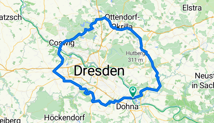
Dresden-Umrundung im Uhrzeigersinn
A cycling route starting in Heidenau, Saxony, Germany.
Overview
About this route
Sehr schöne Tour durch über 40 Dörfer und Stadtteile um Dresden.
Distanz: 111 km
Dauer: 11:00-17:30 Uhr
Fahrzeit: 4 h 47 min
Durchschnitt: 23,3 km/h
Höhenmeter: 1130 hm
Hauptanstiege:
Heidenau zum Lugturm: 70 hm auf 1 km
Hummelmühle nach Possendorf: 130 hm auf 5 km
Freital nach Kesselsdorf: 130 hm auf 6,5 km
Coswig nach Moritzburg: 90 hm
Hermsdorf nach Radeberg: 70 hm
Radeberg in den Karswald: 70 hm
Höchste Punkte:
Possendorf, Kesselsdorf, Karswald
(je knapp über 300 hm)
- -:--
- Duration
- 108.3 km
- Distance
- 670 m
- Ascent
- 670 m
- Descent
- ---
- Avg. speed
- ---
- Max. altitude
Route quality
Waytypes & surfaces along the route
Waytypes
Quiet road
35.6 km
(33 %)
Track
23.2 km
(21 %)
Surfaces
Paved
79.5 km
(73 %)
Unpaved
15.8 km
(15 %)
Asphalt
77 km
(71 %)
Gravel
6.8 km
(6 %)
Continue with Bikemap
Use, edit, or download this cycling route
You would like to ride Dresden-Umrundung im Uhrzeigersinn or customize it for your own trip? Here is what you can do with this Bikemap route:
Free features
- Save this route as favorite or in collections
- Copy & plan your own version of this route
- Split it into stages to create a multi-day tour
- Sync your route with Garmin or Wahoo
Premium features
Free trial for 3 days, or one-time payment. More about Bikemap Premium.
- Navigate this route on iOS & Android
- Export a GPX / KML file of this route
- Create your custom printout (try it for free)
- Download this route for offline navigation
Discover more Premium features.
Get Bikemap PremiumFrom our community
Other popular routes starting in Heidenau
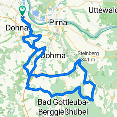
 Pillnitz-LIEBETHALER GRUND-BRAND-Rathen-Zschachwitz
- Distance
- 64.4 km
- Ascent
- 558 m
- Descent
- 551 m
- Location
- Heidenau, Saxony, Germany
 33. Heidenauer RTF 20.09.2014 - 120 km
- Distance
- 114.6 km
- Ascent
- 900 m
- Descent
- 901 m
- Location
- Heidenau, Saxony, Germany
 30. Heidenauer RTF 17.09.2011 - 120 km
- Distance
- 119 km
- Ascent
- 955 m
- Descent
- 955 m
- Location
- Heidenau, Saxony, Germany
 33. Heidenauer RTF 20.09.2014 - 60km -
- Distance
- 56.2 km
- Ascent
- 655 m
- Descent
- 656 m
- Location
- Heidenau, Saxony, Germany
 Wehlen - Hocksteinschänke - Stolpen - Hochland
- Distance
- 67.1 km
- Ascent
- 530 m
- Descent
- 375 m
- Location
- Heidenau, Saxony, Germany
 Borsberg 013-1226hm
- Distance
- 42.3 km
- Ascent
- 0 m
- Descent
- 0 m
- Location
- Heidenau, Saxony, Germany
 Schönfelder Hochlandtour
- Distance
- 44.2 km
- Ascent
- 331 m
- Descent
- 332 m
- Location
- Heidenau, Saxony, Germany
 Schnelle Ausfahrt vom 28.07.17, 18:38
- Distance
- 7.9 km
- Ascent
- 16 m
- Descent
- 16 m
- Location
- Heidenau, Saxony, Germany
Open it in the app