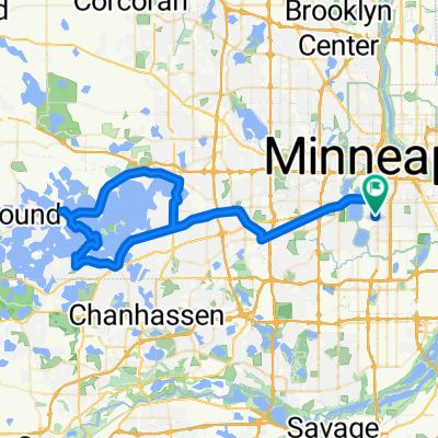
B2B00450 55416>55402 via W 26th St, Cedar Lake Trl, S 10th St, 3rd Ave S
A cycling route starting in Saint Louis Park, Minnesota, United States of America.
Overview
About this route
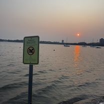
Cedar Lake Pkwy has a bike path. At the intersection of Cedar Lake Pkwy and Cedar Lake Rd, cross the street in order to get on the path which will get onto the Cedar Lake Trail.
Â
- -:--
- Duration
- 9.9 km
- Distance
- 145 m
- Ascent
- 149 m
- Descent
- ---
- Avg. speed
- ---
- Avg. speed
Route quality
Waytypes & surfaces along the route
Waytypes
Undefined
9.9 km
(100 %)
Surfaces
Undefined
9.9 km
(100 %)
Route highlights
Points of interest along the route
Point of interest after 3.3 km
Cross onto the bike path which will go to the Cedar Lake Trail.
Continue with Bikemap
Use, edit, or download this cycling route
You would like to ride B2B00450 55416>55402 via W 26th St, Cedar Lake Trl, S 10th St, 3rd Ave S or customize it for your own trip? Here is what you can do with this Bikemap route:
Free features
- Save this route as favorite or in collections
- Copy & plan your own version of this route
- Sync your route with Garmin or Wahoo
Premium features
Free trial for 3 days, or one-time payment. More about Bikemap Premium.
- Navigate this route on iOS & Android
- Export a GPX / KML file of this route
- Create your custom printout (try it for free)
- Download this route for offline navigation
Discover more Premium features.
Get Bikemap PremiumFrom our community
Other popular routes starting in Saint Louis Park
- Sunday Route
- Distance
- 34.4 km
- Ascent
- 88 m
- Descent
- 88 m
- Location
- Saint Louis Park, Minnesota, United States of America
- Kid Taxi 2
- Distance
- 9 km
- Ascent
- 105 m
- Descent
- 113 m
- Location
- Saint Louis Park, Minnesota, United States of America
- Uptown, Lake Nokomis, Mississippi River, Greenway
- Distance
- 27.7 km
- Ascent
- 63 m
- Descent
- 62 m
- Location
- Saint Louis Park, Minnesota, United States of America
- Kid Taxi 1
- Distance
- 6.4 km
- Ascent
- 14 m
- Descent
- 23 m
- Location
- Saint Louis Park, Minnesota, United States of America
- Regional Trail Loop St. Louis Park
- Distance
- 21.1 km
- Ascent
- 61 m
- Descent
- 63 m
- Location
- Saint Louis Park, Minnesota, United States of America
- minnehaha falls round trip
- Distance
- 30 km
- Ascent
- 67 m
- Descent
- 74 m
- Location
- Saint Louis Park, Minnesota, United States of America
- Cedar Lake Trail, St. Louis Park to 1406 Spruce Pl, Minneapolis
- Distance
- 25.5 km
- Ascent
- 110 m
- Descent
- 126 m
- Location
- Saint Louis Park, Minnesota, United States of America
- Lengthy bike tour through Minneapolis
- Distance
- 38.1 km
- Ascent
- 91 m
- Descent
- 93 m
- Location
- Saint Louis Park, Minnesota, United States of America