

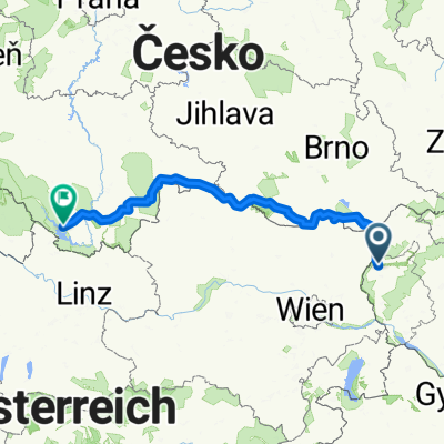
Šumava 2008:V.Leváre-Černá v Pošumaví
A cycling route starting in Malacky, Bratislava Region, Slovakia.
Overview
About this route
V.Leváre-Černá in Šumava
- -:--
- Duration
- 322.5 km
- Distance
- 2,383 m
- Ascent
- 1,973 m
- Descent
- ---
- Avg. speed
- 670 m
- Max. altitude

Route quality
Waytypes & surfaces along the route
Waytypes
Road
64.5 km
(20 %)
Track
45.2 km
(14 %)
Surfaces
Paved
138.7 km
(43 %)
Unpaved
12.9 km
(4 %)
Asphalt
135.5 km
(42 %)
Ground
6.5 km
(2 %)
Route highlights
Points of interest along the route

Photo after 57.5 km
hranicny prechod do rakuska

Photo after 134.7 km
byvaly veterny mlyn
Continue with Bikemap
Use, edit, or download this cycling route
You would like to ride Šumava 2008:V.Leváre-Černá v Pošumaví or customize it for your own trip? Here is what you can do with this Bikemap route:
Free features
- Save this route as favorite or in collections
- Copy & plan your own version of this route
- Split it into stages to create a multi-day tour
- Sync your route with Garmin or Wahoo
Premium features
Free trial for 3 days, or one-time payment. More about Bikemap Premium.
- Navigate this route on iOS & Android
- Export a GPX / KML file of this route
- Create your custom printout (try it for free)
- Download this route for offline navigation
Discover more Premium features.
Get Bikemap PremiumFrom our community
Other popular routes starting in Malacky
 Biely kriz, Kacin, Zohor
- Distance
- 63 km
- Ascent
- 698 m
- Descent
- 703 m
- Location
- Malacky, Bratislava Region, Slovakia
 Malacky- Kostolište- Gajary- Suchohrad
- Distance
- 18.8 km
- Ascent
- 29 m
- Descent
- 42 m
- Location
- Malacky, Bratislava Region, Slovakia
 Duklianskych hrdinov 16 do Duk. hrdinov 6A
- Distance
- 30.5 km
- Ascent
- 104 m
- Descent
- 101 m
- Location
- Malacky, Bratislava Region, Slovakia
 Gajary_Devín
- Distance
- 49.2 km
- Ascent
- 61 m
- Descent
- 66 m
- Location
- Malacky, Bratislava Region, Slovakia
 Kuchyňa - Buková - Pezinská Baba - Kuchyňa
- Distance
- 92.5 km
- Ascent
- 640 m
- Descent
- 639 m
- Location
- Malacky, Bratislava Region, Slovakia
 Šumava 2008:V.Leváre-Černá v Pošumaví
- Distance
- 322.5 km
- Ascent
- 2,383 m
- Descent
- 1,973 m
- Location
- Malacky, Bratislava Region, Slovakia
 vyslap 4 - Rudava back home
- Distance
- 49.9 km
- Ascent
- 179 m
- Descent
- 143 m
- Location
- Malacky, Bratislava Region, Slovakia
 Nedelna siesta v Karpatoch
- Distance
- 65.3 km
- Ascent
- 587 m
- Descent
- 587 m
- Location
- Malacky, Bratislava Region, Slovakia
Open it in the app