

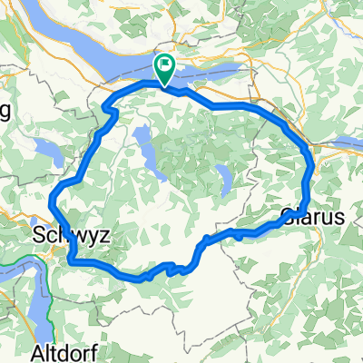
Lachen - Ruchweid - Willerzell - Etzel - Pfäffike
A cycling route starting in Altendorf, Canton of Schwyz, Switzerland.
Overview
About this route
Von See zu see und zurück
- -:--
- Duration
- 34.8 km
- Distance
- 1,028 m
- Ascent
- 1,023 m
- Descent
- ---
- Avg. speed
- ---
- Max. altitude
Route quality
Waytypes & surfaces along the route
Waytypes
Track
10 km
(29 %)
Road
9.5 km
(27 %)
Surfaces
Paved
22 km
(63 %)
Unpaved
8.3 km
(24 %)
Asphalt
18.3 km
(53 %)
Paved (undefined)
3.8 km
(11 %)
Continue with Bikemap
Use, edit, or download this cycling route
You would like to ride Lachen - Ruchweid - Willerzell - Etzel - Pfäffike or customize it for your own trip? Here is what you can do with this Bikemap route:
Free features
- Save this route as favorite or in collections
- Copy & plan your own version of this route
- Sync your route with Garmin or Wahoo
Premium features
Free trial for 3 days, or one-time payment. More about Bikemap Premium.
- Navigate this route on iOS & Android
- Export a GPX / KML file of this route
- Create your custom printout (try it for free)
- Download this route for offline navigation
Discover more Premium features.
Get Bikemap PremiumFrom our community
Other popular routes starting in Altendorf
 #nichtganzzweihundert2025
- Distance
- 203.7 km
- Ascent
- 2,993 m
- Descent
- 2,989 m
- Location
- Altendorf, Canton of Schwyz, Switzerland
 Obersee
- Distance
- 34.4 km
- Ascent
- 260 m
- Descent
- 275 m
- Location
- Altendorf, Canton of Schwyz, Switzerland
 Alpen 2012 - Pragelpass
- Distance
- 110.6 km
- Ascent
- 1,682 m
- Descent
- 1,682 m
- Location
- Altendorf, Canton of Schwyz, Switzerland
 Sattelegg for newbies
- Distance
- 64 km
- Ascent
- 1,099 m
- Descent
- 978 m
- Location
- Altendorf, Canton of Schwyz, Switzerland
 Tour mit Urs
- Distance
- 70.2 km
- Ascent
- 2,047 m
- Descent
- 2,046 m
- Location
- Altendorf, Canton of Schwyz, Switzerland
 Lange Ausfahrt durch Altendorf
- Distance
- 55.9 km
- Ascent
- 1,934 m
- Descent
- 1,934 m
- Location
- Altendorf, Canton of Schwyz, Switzerland
 Lachen - Ruchweid - Willerzell - Etzel - Pfäffike
- Distance
- 34.8 km
- Ascent
- 1,028 m
- Descent
- 1,023 m
- Location
- Altendorf, Canton of Schwyz, Switzerland
 der Grabentrail
- Distance
- 13.4 km
- Ascent
- 710 m
- Descent
- 606 m
- Location
- Altendorf, Canton of Schwyz, Switzerland
Open it in the app