

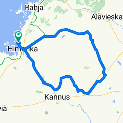
Himanka-Tokola-Kannus-Rautio-Typpö-Pahkala-Pöntiö-Himanka
A cycling route starting in Himanka, North Ostrobothnia, Finland.
Overview
About this route
Minor roads, little traffic, but sensitive to S, SE and E winds
- -:--
- Duration
- 102.9 km
- Distance
- 114 m
- Ascent
- 112 m
- Descent
- ---
- Avg. speed
- ---
- Max. altitude

Route quality
Waytypes & surfaces along the route
Waytypes
Road
44.3 km
(43 %)
Quiet road
13.4 km
(13 %)
Surfaces
Paved
79.3 km
(77 %)
Unpaved
18.5 km
(18 %)
Paved (undefined)
58.7 km
(57 %)
Asphalt
20.6 km
(20 %)
Continue with Bikemap
Use, edit, or download this cycling route
You would like to ride Himanka-Tokola-Kannus-Rautio-Typpö-Pahkala-Pöntiö-Himanka or customize it for your own trip? Here is what you can do with this Bikemap route:
Free features
- Save this route as favorite or in collections
- Copy & plan your own version of this route
- Split it into stages to create a multi-day tour
- Sync your route with Garmin or Wahoo
Premium features
Free trial for 3 days, or one-time payment. More about Bikemap Premium.
- Navigate this route on iOS & Android
- Export a GPX / KML file of this route
- Create your custom printout (try it for free)
- Download this route for offline navigation
Discover more Premium features.
Get Bikemap PremiumFrom our community
Other popular routes starting in Himanka
 Himanka-Kannus-Ullava-Rahkonen-Viitasalo-Toholampi-Jämsä-Kannus-Himanka
- Distance
- 149.9 km
- Ascent
- 165 m
- Descent
- 167 m
- Location
- Himanka, North Ostrobothnia, Finland
 Virpiranta/Himanka-Kannus-Ullava-Ullavanjärvi-Toholampi-Kannus-Virpiranta/Himanka
- Distance
- 146.8 km
- Ascent
- 0 m
- Descent
- 0 m
- Location
- Himanka, North Ostrobothnia, Finland
 Himanka-Tokola-Kannus-Rautio-Typpö-Pahkala-Pöntiö-Himanka
- Distance
- 102.9 km
- Ascent
- 114 m
- Descent
- 112 m
- Location
- Himanka, North Ostrobothnia, Finland
 Virpiranta-Rahja-Siipojoki-Kurikkala-Pahkala-Pöntiö-Himanka-kk-Virpiranta
- Distance
- 67.7 km
- Ascent
- 60 m
- Descent
- 60 m
- Location
- Himanka, North Ostrobothnia, Finland
 Virpiranta-Ohtakari
- Distance
- 23.6 km
- Ascent
- 38 m
- Descent
- 35 m
- Location
- Himanka, North Ostrobothnia, Finland
 1.30.2. Himanka - Jakobstad
- Distance
- 87.8 km
- Ascent
- 66 m
- Descent
- 61 m
- Location
- Himanka, North Ostrobothnia, Finland
 Virpiranta-Rautila-Pöntiö-Himangan-kk-Virpiranta
- Distance
- 25.1 km
- Ascent
- 45 m
- Descent
- 40 m
- Location
- Himanka, North Ostrobothnia, Finland
 Virpiranta-Tokola-Kannus Airport-Eskola-Rautio-Typpö-Pahkala-Pöntiö-Virpiranta
- Distance
- 110.9 km
- Ascent
- 126 m
- Descent
- 121 m
- Location
- Himanka, North Ostrobothnia, Finland
Open it in the app