
Mit dem Rad durchs Mittelalter im Altmühltal
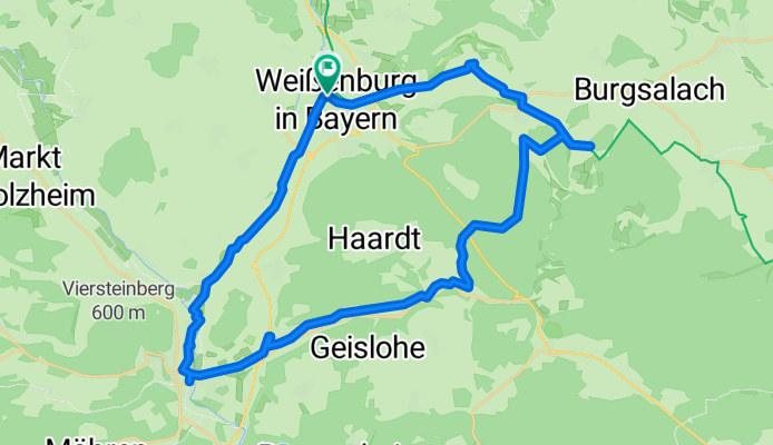
A cycling route starting in Weißenburg in Bayern, Bavaria, Germany.
Overview
About this route
User Beschreibung
Die Familientour ist für Kinder, die sicher mit dem Rad fahren und leichte Steigungen bewältigen können, gut geeignet.
Highlights:
Sie druchradeln das stille, romantische Schambachtal mit kleinen Juradörfern und der idyllisch gelegenen Gunthildis-Kapelle. Nach einem sanften Anstieg erreichen Sie (versteckt im Wald) die Reste eines römischen Kleinkastells. Talwärts geht es zurück ins mittelalterliche Weißenburg, wo wir Ihnen den Besuch des Limesinformationszentrums, des Römerkastells und der Thermen empfehlen. Auf dem Rückweg radeln Sie am Karlsgraben (Fossa Carolina) entlang, einem imposanten Kanalbauprojekt Karls des Großen aus dem Jahr 793.
- -:--
- Duration
- 39 km
- Distance
- 315 m
- Ascent
- 314 m
- Descent
- ---
- Avg. speed
- ---
- Max. altitude
Route quality
Waytypes & surfaces along the route
Waytypes
Track
19.6 km
(50 %)
Road
8.6 km
(22 %)
Surfaces
Paved
16.5 km
(42 %)
Unpaved
15.6 km
(40 %)
Gravel
14.8 km
(38 %)
Asphalt
12.4 km
(32 %)
Continue with Bikemap
Use, edit, or download this cycling route
You would like to ride Mit dem Rad durchs Mittelalter im Altmühltal or customize it for your own trip? Here is what you can do with this Bikemap route:
Free features
- Save this route as favorite or in collections
- Copy & plan your own version of this route
- Sync your route with Garmin or Wahoo
Premium features
Free trial for 3 days, or one-time payment. More about Bikemap Premium.
- Navigate this route on iOS & Android
- Export a GPX / KML file of this route
- Create your custom printout (try it for free)
- Download this route for offline navigation
Discover more Premium features.
Get Bikemap PremiumFrom our community
Other popular routes starting in Weißenburg in Bayern
 28 km training
- Distance
- 28.9 km
- Ascent
- 161 m
- Descent
- 161 m
- Location
- Weißenburg in Bayern, Bavaria, Germany
 MFC 2010, Auf den Spuren der Römer
- Distance
- 125.3 km
- Ascent
- 887 m
- Descent
- 887 m
- Location
- Weißenburg in Bayern, Bavaria, Germany
 Brombachsee - Ellingen
- Distance
- 51.7 km
- Ascent
- 474 m
- Descent
- 474 m
- Location
- Weißenburg in Bayern, Bavaria, Germany
 Weissenburg-Wassertrüdingen-Weissenburg
- Distance
- 91.8 km
- Ascent
- 749 m
- Descent
- 765 m
- Location
- Weißenburg in Bayern, Bavaria, Germany
 Stadtmauer Weißenburg – Kastell und Römerbad - Wettelsheim
- Distance
- 32.4 km
- Ascent
- 273 m
- Descent
- 276 m
- Location
- Weißenburg in Bayern, Bavaria, Germany
 Altmühlsee – Gunzenhausen
- Distance
- 61.8 km
- Ascent
- 459 m
- Descent
- 459 m
- Location
- Weißenburg in Bayern, Bavaria, Germany
 Brombachsee
- Distance
- 13.2 km
- Ascent
- 176 m
- Descent
- 166 m
- Location
- Weißenburg in Bayern, Bavaria, Germany
 Weissenburg - Krumbach (9.Tag Stralsund - Lindau)
- Distance
- 122.5 km
- Ascent
- 554 m
- Descent
- 499 m
- Location
- Weißenburg in Bayern, Bavaria, Germany
Open it in the app