
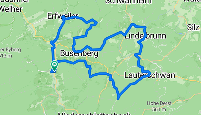
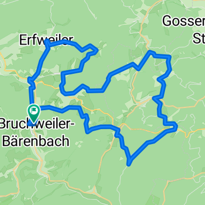
Bruchweiler 37Km 531m
A cycling route starting in Bruchweiler-Bärenbach, Rhineland-Palatinate, Germany.
Overview
About this route
- -:--
- Duration
- 37.2 km
- Distance
- 529 m
- Ascent
- 528 m
- Descent
- ---
- Avg. speed
- ---
- Max. altitude

Route quality
Waytypes & surfaces along the route
Waytypes
Track
22.7 km
(61 %)
Quiet road
7.1 km
(19 %)
Surfaces
Paved
22.7 km
(61 %)
Unpaved
10 km
(27 %)
Asphalt
17.1 km
(46 %)
Gravel
7.1 km
(19 %)
Continue with Bikemap
Use, edit, or download this cycling route
You would like to ride Bruchweiler 37Km 531m or customize it for your own trip? Here is what you can do with this Bikemap route:
Free features
- Save this route as favorite or in collections
- Copy & plan your own version of this route
- Sync your route with Garmin or Wahoo
Premium features
Free trial for 3 days, or one-time payment. More about Bikemap Premium.
- Navigate this route on iOS & Android
- Export a GPX / KML file of this route
- Create your custom printout (try it for free)
- Download this route for offline navigation
Discover more Premium features.
Get Bikemap PremiumFrom our community
Other popular routes starting in Bruchweiler-Bärenbach
 Bruchweiler 37Km 531m
- Distance
- 37.2 km
- Ascent
- 529 m
- Descent
- 528 m
- Location
- Bruchweiler-Bärenbach, Rhineland-Palatinate, Germany
 Bad Bergzabern Rundweg
- Distance
- 49.5 km
- Ascent
- 453 m
- Descent
- 473 m
- Location
- Bruchweiler-Bärenbach, Rhineland-Palatinate, Germany
 Frankreichroute ab Bärenbach
- Distance
- 53.1 km
- Ascent
- 443 m
- Descent
- 442 m
- Location
- Bruchweiler-Bärenbach, Rhineland-Palatinate, Germany
 Talstraße 33, Bruchweiler-Bärenbach nach Boulevard Clemenceau 4, Wissembourg
- Distance
- 127.3 km
- Ascent
- 62 m
- Descent
- 103 m
- Location
- Bruchweiler-Bärenbach, Rhineland-Palatinate, Germany
 Bruchweiler-Bärenbach nach Erlenbach
- Distance
- 17.4 km
- Ascent
- 221 m
- Descent
- 224 m
- Location
- Bruchweiler-Bärenbach, Rhineland-Palatinate, Germany
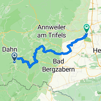 Radtour_Bruchweiler nach Landau
- Distance
- 45.2 km
- Ascent
- 489 m
- Descent
- 542 m
- Location
- Bruchweiler-Bärenbach, Rhineland-Palatinate, Germany
 GPS_2023-08-10_081657 - Dahnrunde
- Distance
- 57.6 km
- Ascent
- 1,621 m
- Descent
- 1,518 m
- Location
- Bruchweiler-Bärenbach, Rhineland-Palatinate, Germany
 Napoleonfels-Tour Bruchweiler-Bärenbach
- Distance
- 12.7 km
- Ascent
- 357 m
- Descent
- 359 m
- Location
- Bruchweiler-Bärenbach, Rhineland-Palatinate, Germany
Open it in the app