
VELOREGIO_01.
A cycling route starting in Bük, Vas County, Hungary.
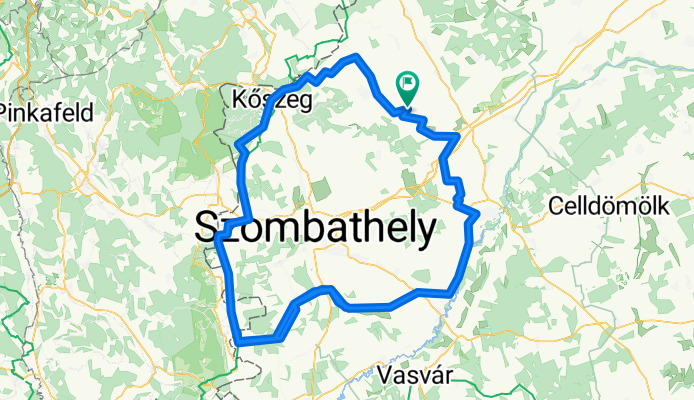
Overview
About this route
This route was primarily designed for road cyclists, but along with varied terrain it offers numerous sights to travelers, making it suitable for a two-day or longer tour depending on fitness level. Along the route there are many accommodation options – at the beginning and end of the route, cyclists can refresh at the baths of Bükfürdő and make use of additional wellness facilities.
- -:--
- Duration
- 194.4 km
- Distance
- 382 m
- Ascent
- 382 m
- Descent
- ---
- Avg. speed
- ---
- Max. altitude

Route quality
Waytypes & surfaces along the route
Waytypes
Track
21.4 km
(11 %)
Quiet road
19.4 km
(10 %)
Surfaces
Paved
44.7 km
(23 %)
Unpaved
21.4 km
(11 %)
Asphalt
42.8 km
(22 %)
Gravel
11.7 km
(6 %)
Route highlights
Points of interest along the route

Point of interest after 0 km
HU Kneipp Park Bük, Termál krt. 39, 9740 Magyarország 47.383833, 16.785310 Nem mindennapi élményben lehet részünk, amikor mezítláb végigsétálunk ezen a több mint 500 méteres száraztaposón. Végigmehetünk a homokos, a kisebb-, és nagyobb kavicsos, a faháncsos és tobozos szakaszokon. A Kneipp Park eltérő anyagú és tapintású részei a talpunk különböző reflexpontjait masszírozzák, így jó hatással vannak a vérkeringésre, felfrissítenek, a rendszeres használatuk pedig pozitív hatással van az anyagcserére. A különböző felületeken járva érdemes a környezet más szépségeinek is figyelmet szentelni – az ösvény elejére visszaérve pedig lemoshatjuk a séta nyomait és megpihenhetünk a padokon. DE Kneipp Park Bük, Termál krt. 39, 9740 Ungarn 47.383833, 16.785310 Es ist kein alltägliches Erlebnis, wenn wir auf dieser über 500 Meter langen, trockenen Strecke barfuß gehen. Wir können den sandigen Boden, oder mit kleinen Steinen, Zapfen und Bast vorbeigehen. Die verschiedenen materiellen und taktilen Bereiche des Kneipp Parks massieren die verschiedenen Reflexpunkte unserer Füße, so dass sie die Durchblutung positiv beeinflussen, sie erfrischen und ihre regelmäßige Anwendung beeinflusst den Stoffwechsel positiv. Beim Gehen auf verschiedenen Oberflächen lohnt es sich, auf die anderen Schönheiten der Umgebung zu achten. Wenn Sie an den Anfang des Pfades zurückkehren, können Sie die Spuren des Spaziergangs abwaschen und sich auf den Bänken ausruhen. EN Kneipp Park Bük, Termál krt. 39, 9740 Hungary 47.383833, 16.785310 Walking barefoot on this 500 metres long dry pathway is a quite unique experience. We can walk through the sand, the smaller and bigger gravels, the phloems and the pine-cones. The various materials with different feels touch different reflex points of out feet, and thus they have a great healing affect to our bloodstreams, they regenerate us, and their regular usage has a positive affect on our metabolism. While walking on various surfaces we should also pay attention to other beauties of our surroundings – and after we get back to the beginning of the path, we can wash the marks of the hike off, and have a rest on the benches.

Point of interest after 0 km
HU Bükfürdő Thermal & Spa Bük, Termál krt. 2/A, 9740 Magyarország +36 94 558 080 E-mail: marketing@bukfurdo.hu http://www.bukfurdo.hu/ 47.381244, 16.785496 Bükben 1965-ben minősítették gyógyvízzé az egyedi összetételű termálvizet, és a medencék, később a fedett fürdő építésével, majd további fejlesztésekkel Bükfürdő fokozatosan Európa-szerte ismert gyógyfürdő és gyógyhely lett. A Bükfürdő Thermal & Spa 14 hektáros, árnyas fákkal borított parkban fekvő fürdőkomplexum 34 medencével, több mint ötezer négyzetméter vízfelülettel, gyógy-, strand- és élményfürdővel, modern szaunavilággal és wellness centrummal, elismert gyógyászati részleggel, kempinggel áll a vendégek rendelkezésére. A gyógyulni vágyókat gyógyvizes medencék, gyógy- és wellness kezelések, gyógykúrák, nyugodt pihenés, a gyermekes családokat élmény- és gyermekmedencék, játszótér, beltéri és kültéri csúszdák, színes játékokkal felszerelt játszószoba, önfeledt játék és szórakozás várja, az aktív kikapcsolódást kedvelők sportpályák, úszómedencék és vidám szórakoztató programok közül választhatnak. DE Bükfürdő Thermal & Spa Bük, Termál krt. 2/A, 9740 Magyarország +36 94 558 080 E-mail: marketing@bukfurdo.hu http://www.bukfurdo.hu/ 47.381244, 16.785496 Das Wasser mit einzigartiger Zusammensetzung wurde in 1965 als Thermalwasser anerkannt. Durch den Bau der Becken, später des überdachten Bades und der weiteren Entwicklung wurde Bükfürdő zu einem in ganz Europa bekannten Spa. Das Bükfürdő Thermal & Spa ist ein 14 Hektar großer Park mit schattigen Bäumen und bietet 34 Schwimmbecken mit mehr als 5.000 Quadratmetern Wasserfläche, Spa, Strand- und Erlebnisbädern, eine moderne Saunawelt- und Wellnesscenter, mit anerkannter medizinischer Abteilung und einen Campingplatz. Für Familien haben wir Erlebnis- und Kinderbecken, Spielplatz, Rutschen im Innen- und Außenbereich, Spielzimmer mit buntem Spielzeug. Für die aktive Erholung suchen haben wir Sportaktivitäten, Schwimmbecken und Unterhaltungsprogramme bereitet. EN Bükfürdő Thermal & Spa Bük, Termál krt. 2/A, 9740 Hungary +36 94 558 080 E-mail: marketing@bukfurdo.hu http://www.bukfurdo.hu/ 47.381244, 16.785496 The uniquely composed thermal water of Bük was graded as mineral, medicinal water in 1965, and with the construction of the pools and later on the indoor baths, as well as further improvements, Bükfürdő became a known spa and health resort all over Europe. The Bükfürdő Thermal & Spa has 14 acres, with a park full of shady trees and its spa complex of 34 pools, more then five thousand sqaure metres of water surface, healing, swimming and experience pools, modern sauna world and wellnes center, a recognized medical department and camping area. Thermal pools, healing and wellness treatments and calm recreation awaits those wanting to heal, and for families with children they have fun pools and children pools, a playground, indoors and outdoors slides, a playing room equipped with colorful toys, and carefree games and fun. Those seeking active recreation can chose from sports courts, swimming pools and various joyful programmes.

Point of interest after 1.6 km
HU Kristálytorony Kalandpark Bükfürdő Bük, Nyárfa u. 2, 9737 Magyarország +36 94 558 030 info@kristalytorony.hu http://www.kristalytorony.hu/ 47.377613, 16.772747 A Magyarországon egyedülálló, 3 szintes kalandpályát 90 elem teszi teljessé. Saját döntésünk szerint haladhatunk, akár kihagyva a nehezebb elemeket, vagy éppen megismételve a számunkra tetsző szakaszokat. A kalandpályán egyszerre 120 fő kalandozhat. A torony lábánál elhelyezkedő Mini Kristály Torony pedig már 3 éves kortól várja a gyerekeket, akik önállóan, száz százalékos biztonság mellett tudják próbára tenni képességeiket. Egyedülálló biztonsági rendszer óvja a mászókat, nem kell tehát aggódnunk magunk és egymás miatt. Ha pedig szerencsésen földet értünk, kiváló süteményekkel, házi fagylalttal, limonádéval ünnepelhetünk a Villa Rosato cukrászdában vagy akár a 225m2 Kristály Torony tetőteraszon, csodálatos panoráma mellett. DE Kristálytorony Kalandpark Bükfürdő /Abenteuerpark Bük, Nyárfa u. 2, 9737 Magyarország +36 94 558 030 info@kristalytorony.hu http://www.kristalytorony.hu/ 47.377613, 16.772747 Der einzigartige 3-stufige Abenteuer Kurs in Ungarn wird durch 90 Elemente vollständig. Es ist Ihre Entscheidung welche Hindernisse sie überspringen oder wiederholen möchten, Spaß is garantiert. Gleichzeitig können 120 Personen die Strecke benutzen. Am Fuße des Turms wartet der Kristall Turm auf Kinder ab 3 Jahren, die ihre Fähigkeiten mit hundertprozentiger Sicherheit testen können. Ein einzigartiges Sicherheitssystem schützt Kletterer, so dass wir uns weder um uns selbst noch um andere sorgen müssen. Nachdem Abenteuer können Sie in die Konditorei Villa Rosato besuchen oder auf der 225 m² großen Crystal Turm-Dachterrasse mit herrlichem Panorama, tolle Kuchen, hausgemachtem Eis und Limonade genießen. EN Kristálytorony (Crystal Tower) Adventure Park of Bükfürdő Bük, Nyárfa u. 2, 9737 Magyarország +36 94 558 030 info@kristalytorony.hu http://www.kristalytorony.hu/ 47.377613, 16.772747 The one of a kind adventure park has a 3 story adventure court with 90 elements. We can chose our own path through it, even leave out the harder elements, or repeat the parts that we liked the most. There can be up to 120 adventurers on the court at the same time. By the feet of the tower we have a Miniature Crystal Tower, which children older than three years old can try independently, with a hundred percent safety. A unique safety system protects the climbers, so we don’t have to worry about ourselves and each other. And when we safely reach the ground, we can have a celebration at the Villa Rosato pastry shop with fantastic cakes, homemade ice-cream and lemonade, or on the 225 m2 roof terrace of the Crystal Tower, with a wonderful panorama.

Point of interest after 3.9 km
HU Birdland Golf and Country Bük, Golf út 4, 9740 Magyarország +36 94 801 660 http://birdlandgolf.net/hu/ 47.388437, 16.784100 Magyarország első színvonalas, nemzetközileg minősített 18 lyukú championship golfpályája található a villapark szomszédságában. A szépségéről Európa-szerte ismert, 7 tóval kiépített pálya több, mint 100 hektáron terül el. A Birdland Golf&Country Club azt szeretné, hogy vendégeik megismerkedjenek a világ egyik legnépszerűbb sportjátékával, és egyúttal azzal az életformával is, amit egy golfklub nyújt tagjai és vendégei számára. Éppen ezért a klub egyszerű halandóknak is szervez golfoktatást, mely során az alapokat mind elméletben mind gyakorlatban elsajátíthatják DE Birdland Golf and Country Bük, Golf út 4, 9740 Magyarország +36 94 801 660 http://birdlandgolf.net/hu/ 47.388437, 16.784100 Der erste hochqualitative, international qualifizierte 18-Loch-Golfplatz von Ungarn befindet sich in der Nachbarschaft des Villenparkviertels. Die europaweit bekannte 7-Hektar-Strecke umfasst mehr als 100 Hektar. A Birdland Golf&Country Club möchte ihre Geste mit dieser einzigartiger Sportart bekannt machen und den Lebensstil präsentieren welchen ein Golfclub biete kann. Deswegen bietet der Club für jeden Golfkurse an. EN Birdland Golf and Country Bük, Golf utca 4, 9740 Hungary +36 94 801 660 http://birdlandgolf.net/hu/ 47.388437, 16.784100 The first high-standard, internationally classified 18 hole championship golf course of Hungary can be found near the villa park. The course, known for its beauty all over Europe, is equipped with seven lakes, and is set on 100 acres. The Birdland Golf&Country Club wants its visitors to get to know not only one of the most popular sports games of the world, but also the lifestyle, that a golf club can provide to its members and visitors. So for this the club organizes golf education for mere mortals as well, through which they have a chance to learn the theoratical and practical parts of its basis.

Point of interest after 3.9 km
HU Greenfield Hotel Golf & Spa****superior 9740 Bükfürdő, Golf u. 4. Telefon: +36 94 801 600 Fax: +36 94 801 601 E-mail: reservation@greenfieldhotel.net Web: www. greenfieldhotel.net 47.389282, 16.780960 A Greenfield Hotel Golf & Spa teljes körű szolgáltatást nyújt 3 500 m2-es, exkluzív wellness és spa központjában, amely több mint 100 féle tradicionális gyógy-, egzotikus (ayurveda, thai) és kényeztető kezelést és masszázst kínál. Számos gyógyvizes medence saját, minősített gyógyvízzel töltve, illetve egy babapancsoló csúszdával és várja a víz szerelmeseit. A felfrissülésre vágyó vendégeink az egyedülálló szaunavilág jótékony hatását élvezhetik, melyet. Magyarország első 18 lyukú golfpályája 1991-ben nyílt Bükfürdőn. Élvezze az egyedi világot, amit a pannon klíma, az idillikus táj és a gyönyörűen gondozott, 100 hektáron elterülő golfpálya varázslatos panorámája nyújt. Összhangban a természettel: 1 000 000 m2-en 10 000 nyárfa, 7 tó, és 100 különböző madárfaj alkot egyedülállóan nyugodt környezetet. DE Greenfield Hotel Golf & Spa****superior 9740 Bükfürdő, Golf u. 4. Telefon: +36 94 801 600 Fax: +36 94 801 601 E-mail: reservation@greenfieldhotel.net Web: www. greenfieldhotel.net 47.389282, 16.780960 Das Greenfield Hotel Golf & Spa bietet umfassenden Service in seinem 3 500 m² großen exklusiven Spa Center. Das Spa bietet über 100 traditionelle Therapien, exotische (Ayurveda, Thai) und verwöhnende Behandlungen und Massagen. Viele Heilwasserpools sind mit ihrem eigenen qualifizierten Heilwasser gefüllt, und es gibt einen Babybecken mit Rutsche für die kleinen Racker. Unsere Gäste können die erfrischenden Wirkungen der Saunawelt genießen. Der erste 18-Loch-Golfplatz Ungarns wurde in 1991 im Bükfürdő eröffnet. Genießen Sie die einzigartige Welt des Pannon-Klima, die idyllische Landschaft und den wunderschön gepflegten 100 Hektar großen Golfplatz. Im Einklang mit der Natur: auf 1 000 000 m2 mit 10.000 Pappeln, 7 Seen und mit dem sang 100 verschiedenen Vogelarten haben wir für Sie eine einzigartig ruhige Umgebung geschaffen. EN Greenfield Hotel Golf & Spa****superior 9740 Bükfürdő, Golf u. 4., Hungary Telefon: +36 94 801 600 Fax: +36 94 801 601 E-mail: reservation@greenfieldhotel.net Web: www. greenfieldhotel.net 47.389282, 16.780960 A Greenfield Hotel Golf & Spa offers a full service on its 3500 square metres big exclusive wellness and spa center, offering more than a 100 types of traditional healing, exotic (ayurveda, thai) and relaxing treatments and massages. Many thermal water pools filled with their own, classified mineral water awaits those fond of water, and also a baby paddling pool with a slide. Our guests looking for refreshment can enjoy the beneficial effects of the unique sauna world. The first 18 hole golf course of Hungary was established in 1991 in Bükfürdő. Enjoy the special world granted by the Pannonian climate, the idyllic view and the magical panorama of the 100 acres big, beautifully tended golf course. In harmony with nature: on the 1 000 000 sqaure meters the uniquely calm environment is created by 10 000 aspens, 7 lakes, and 100 different species of birds.

Point of interest after 3.9 km
HU Napsugár Játszópark Bük, 9737 Magyarország +36 70 336 8633 info@napsugarpark.hu http://www.napsugarpark.hu/ 47.392346, 16.757471 A Napsugárpark új lehetőségként nyitotta meg kapuit Bükön a játék, a kaland, a sport forrásaként. A kisebbeknek egy két emeletes játszólabirintus a nagyobbaknak egy 4 pályás trambulin, egy 4 szintes izgalmas elemekkel kombinált labirintus rendszer nyújt felejthetetlen kalandokat. Játszóparkunkban országosan egyedülálló két különlegesség is található! Az egyik az úgynevezett SPIN FRIZZ henger, mely Magyarországon csak itt található meg, a másik egy nyári korcsolyapálya. A parkban ezeken kívül kétpályás bowling, amerikai fallabda-pálya, valamint fitnessterem, 15 elemes játszótér, 9 lyukú mini golf pálya, homokozó, valamint a tó körül főzésre-sütésre alkalmas sétány is található. DE Napsugár Játszópark/ Spielpark Bük, 9737 Magyarország +36 70 336 8633 info@napsugarpark.hu http://www.napsugarpark.hu/ 47.392346, 16.757471 Der Napsugár Park öffnete seine Türen als neue Gelegenheit in Bük als Quelle für Spiele, Abenteuer und Sport. Die kleineren haben einen zweistöckigen Spielplatz für die größeren gibt es 4 Hindernisstrecken mit Trampolin und Labyrinthen. Abenteuer sind garantiert. Unser Spielpark hat zwei einzigartige Attraktionen! Die erste ist der sogenannte SPIN FRIZZ-Zylinder, der in Ungarn nur Hier zu finden ist, und die zweite ist eine Sommer-Eisbahn. Im Park gibt es auch eine zweigleisige Bowlingbahn, einen amerikanischen Squashplatz, einen Fitnessraum, einen Spielplatz, einen 9-Loch-Minigolfplatz, einen Sandkasten und eine Promenade am See die auch zum Kochen geeignet ist. EN Sunshine Fun Park Bük, 9737 Magyarország +36 70 336 8633 info@napsugarpark.hu http://www.napsugarpark.hu/ 47.392346, 16.757471 The Sunshine Park opened its gates as a new opportunity, a source of games, adventures and sports. For the little ones there is a two-story playing-labyrinth, and for bigger children there is a trampoline with 4 courts and a 4-story labyrinth with exciting elements is responsible for the unforgettable adventures. In our fun park there are two peculiarity that are unique in the whole country! One is the so called SPIN FRIZZ barrel, one of its kind in Hungary, and the other one is a summer skating-rink. Apart from these, there is a bowling alley with two courts, an american squash court, a fitness, a playground with 15 elements, a miniature golf course with 9 holes, a sand pit, and around the lake there are walk-ways suitable for cooking.

Point of interest after 26.7 km
HU Kőszegi Téglagyári-tó Kőszeg, 9730 Magyarország +36 30 986 1660 http://www.koszegitavak.hu/ 47.385850, 16.560672 A tó az agyagbányászat során jött létre a vadregényes, egy hektáros, 2,5-3,5 méter mély tó. Ez volt Kőszeg első tava. Északi, nyugati és déli oldalon meredek pertszegély övezi, amely keleti irányba fokozatosan lapos partszakaszba megy át. Parkolásra a vízparton van lehetőség, ahol hirdetőtábla tájékoztatja a horgászokat az aktuális tudnivalókról. Kapitális pontyok, amurok, harcsák kerültek ki a tóból, valamint a csukaállományára is büszke. Nem ritkák az 1 kg-os kárászok. A bojlizók is szívesen látogatják a tavat. DE Kőszegi Téglagyári-tó / Téglagyár See in Kőszeg Kőszeg, 9730 Ungarn +36 30 986 1660 http://www.koszegitavak.hu/ 47.385850, 16.560672 Der See wurde während den Tonabbau geschaffen, es ist ein romantischer 2,5 bis 3,5 Meter tiefr See. Dies war der erste See in Kőszeg. Im Norden, Westen und Süden gibt es eine steile Senkrechte nach Osten, die allmählich zu einer flachen Küstenlinie übergeht. Es gibt Parkplätze am Wasser, wo Werbetafeln die Angler über aktuelle Informationen informieren. Kapitale Karpfen Graskarpfen, Flusswels und ein Hechtbestand befindet sich auch im See. 1 kg größe Karausche sind auch nicht ungewöhnlich. Die „bojli” betrieber können den See auch besuchen. EN Brickyard Lake of Kőszeg Kőszeg, 9730 Hungary +36 30 986 1660 http://www.koszegitavak.hu/ 47.385850, 16.560672 The one acre big, 2,5-3,5 deep lake was formed during clay mining. This was the first lake of Kőszeg. It is surrounded by steep shores from the north, west and south, that gradualy turns into a flatter beach on the east side. There are parking opportunities on the shore, where a notice board informs fishermen about the current informations. Capital carps, amurs and catfish have been caught in the lake, and it is also proud of its pike stock. 1 kilogramm crucians are also not rare.

Point of interest after 27.4 km
HU Décsi Lajos 9730 Kőszeg, Alsó Körút 37. sz. Tel: +36 30 3207390 Tevékenység: almalé előállító Nyitva tartás: egész évben, előzetes egyeztetés szükséges 47.387085, 16.553273 DE 9730 Kőszeg, Alsó Körút 37. sz. Tel: +36 30 3207390 Aktivität: Apfelsaft Herstellung Öffnungszeiten: das ganze Jahr über, vorherige telefonische Beschprechung nötig 47.387085, 16.553273 EN Lajos Décsi 9730 Kőszeg, Alsó Körút 37. sz. Phone: +36 30 3207390 Activity: apple juice producer Open: all year long, consultation via phone is required 47.387085, 16.553273

Point of interest after 28.2 km
HU Csónakázó-tó Kőszeg, 9730 Magyarország https://koszegvendeghaz.hu/csonakazo-to.html 47.398737, 16.535954 A város peremén, az osztrák határtól mindössze néhány száz méterre található tó a csend és béke szigete, vagyis ideális környezet piknikezésre, pihentető, romantikus sétára. A tó melletti hegyek látványa, a friss levegő és a szép környezet segítik elfelejteni a hétköznapok gondjait. DE Csónakázó-tó / Csónakázó (Rudernd) See Kőszeg, 9730 Ungarn https://koszegvendeghaz.hu/csonakazo-to.html 47.398737, 16.535954 Am Rande der Stadt gelegen, nur wenige hundert Meter von der österreichischen Grenze entfernt, ist die Insel der Stille und des Friedens die ideale Umgebung für ein Picknick, einen erholsamen, romantischen Spaziergang. Der Anblick an die Berge am See, die frische Luft und die wunderschöne Umgebung helfen, die Probleme des Alltags zu vergessen. EN Boating Lake Kőszeg, 9730 Hungary https://koszegvendeghaz.hu/csonakazo-to.html 47.398737, 16.535954 By the edge of the town, just a few hundred metres from the Austrian border, we can find the island of quiet and peace, the ideal location for picnics, or a relaxing, romantic walk. The sight of the mountains next to the lake, the frech air and the beautiful environment helps us to forget the troubles of the everyday life.

Point of interest after 28.5 km
HU Trianoni kereszt Kőszeg, 9730 Magyarország https://www.kozterkep.hu/~/20628/Trianoni_kereszt_Koszeg_1936.html 47.400722, 16.527158 A kőszegi hegyoldal 1936-ban politikai szerepet kapott, amikor a trianoni békeszerződés mementójaként vasbeton keresztet építettek rá. A hármas halomra illesztett, mintegy 8 méteres emlékmű terve már 1932-ben elkészült. Gyöngyös Endre, Kőszeg város aljegyzője, későbbi polgármestere szemelte ki helyszínnek, tekintettel arra, hogy innen az emlékmű az elcsatolt területekre néz, illetve onnan is jól látható. A Trianoni-keresztre később az osztrák oldalon a közeli Saint-Germaini kereszt építésével „válaszoltak”, amellyel a Párizs környéki békék őket érintő részeiről emlékeztek meg. 1945 után a szigorúan őrzött határrészhez tartozott, sokáig csak a határőrök közelíthették meg. 1989 után vált újra teljesen szabadon látogathatóvá. 1993-ban felújították, emléktáblával látták el, emlékezve a vasfüggöny időszakára. DE Trianoni kereszt Kőszeg, 9730 Magyarország https://www.kozterkep.hu/~/20628/Trianoni_kereszt_Koszeg_1936.html 47.400722, 16.527158 In 1936 erhielt der Hügel von Kőszeg eine politische Rolle, als er als Erinnerung an den Friedensvertrag von Trianon ein Stahlbetonkreuz errichtet wurde. Auf dem trilateralen Hügel wurde ein etwa 8 Metern Großer Kreuz im 1932 fertiggestellt. Gyöngyös Endre, Notar und später der Bürgermeister der Stadt Kőszeg, hat en Platz für das Denkmal ausgewählt. Von hier aus kann man die abgetrennten Gebieten besichtigen. Die Antwort auf das Kreuz kam später von der österreichischen Seite in form eines Saint-Germain Kreuzes, so erinnern sich unsere Nachbarn auf Ihren teil des Paktes. Nach 1945 gehörte es zur streng bewachten Grenze, für lange Zeit hatten nur die Grenzsoldaten zutritt. Nach 1989 wurde der Besuch völlig frei. Das im 1993 renovierte Denkmal erinnert an den die Zeit des Eisernen Vorhangs . EN Trianon Cross Kőszeg, 9730 Magyarország https://www.kozterkep.hu/~/20628/Trianoni_kereszt_Koszeg_1936.html 47.400722, 16.527158 The Kőszeg hillsloap gained a political meaning in 1936 after the cross was built on it as a memento of the Trianon Treaty. The place was selected by Endre Gyöngyös, notary and later mayor of Kőszeg with the reason that it overlooked and could be seen by the territories lost in the treaty by Hungary. The Cross was „answered” with the Saint-Germain Cross by Austrian authorities, commemorating the Paris Treaties relating Austria. After 1945, it was part of the border control security area and only officials could approach it until 1989, from when admission is free again. The cross was renovated in 1993 with a plate added to it commemorating the times of the Iron Curtain.

Point of interest after 28.7 km
HU Főnix-ház Kőszeg, Rajnis utca 9., 9730 Magyarország +36 94 361 258 https://www.koszeg.hu/hu/koszeg/muzeumok/fonix-haz-szamos-marcipan-muzeum-36.html 47.389813, 16.539350 Szamos Marcipán Mesegaléria Több, mint egy évtizede nyílt meg Kőszegen, a Főnix Házban a Szamos Marcipán Mesegaléria. A Jurisics vár Elővárának szépen felújított termeiben a meseirodalom kedvelt alakjai szinte életre kelnek – marcipán szobor formában. Látható itt Pöttöm Panna, a tücsök és a hangya, az aranyszőrű bárány, Lúdas Matyi, Csipkerózsika és sorolhatnánk még sokáig. DE Főnix-ház Kőszeg, Rajnis utca 9., 9730 Magyarország +36 94 361 258 https://www.koszeg.hu/hu/koszeg/muzeumok/fonix-haz-szamos-marcipan-muzeum-36.html 47.389813, 16.539350 Szamos Marzipan Märchengalerie Die Szamos Marzipan Märchengalerie ist schon mehr als 10 Jahre geöffnet, und wartet auf Ihre Besucher im Főnix Haus. In den schön renovierten Räumen der Festung Jurisics kommen die Lieblingsfiguren der Märchen zum leben - in Form von Marzipan-Skulpturen. Wir sehen hier Pöttöm Panna, die Grille und die Ameise, das goldhaarige Lamm, Matyi Lúdas, Dornröschen und viel mehr. EN Főnix House, Szamos Marzipan Fairy Tale Gallery Kőszeg, Rajnis utca 9., 9730 +36 94 361 258 https://www.koszeg.hu/hu/koszeg/muzeumok/fonix-haz-szamos-marcipan-muzeum-36.html 47.389813, 16.539350 The gallery opened more than a decade ago in the Főnix House, the well-renovated front building of the Jurisics Castle, exhibiting the popular heroes of fairy tales in the form of marzipan statues.

Point of interest after 28.7 km
HU Kőszeg-Vashegy Borút 9730 Kőszeg, Rajnis u. 7. Tel: +36 94 563120 E-mail: natur@irottkonaturpark.axelero.net Web: www.naturpark.hu 47.389750, 16.539596 Hazánk legnyugatibb borvidéke a Soproni Borvidék, melyhez két körzet tartozik: a soproni és a kőszegi, ez utóbbi Vas megyében a Vas-hegy és a Kőszeghegyalja lankáin alakult ki. Az egyedülálló értékeket rejtő vidéken haladó Kőszeg-Vashegy Borút központja természetesen „az Alpokalja ékszerdoboza”-ként is emlegetett Kőszeg. A kőszegi borászok összefogásával jött létre a Kőszegi borút, mely a városi és környéki szölöterületeket, pincéket köti össze és mutatja be. Az egész napos program keretében a borászok a pincéikben várják a vendégeket. A pincék egyénileg is felkereshetők, vagy a 10.00 órakor induló csoportokhoz csatlakozva borkóstolóval, ebéddel egybekötött programon vehetnek részt az érdeklődők. DE Kőszeg-Vashegy Borút 9730 Kőszeg, Rajnis u. 7. Tel: +36 94 563120 E-mail: natur@irottkonaturpark.axelero.net Web: www.naturpark.hu 47.389750, 16.539596 Die westlichste Weinregion Ungarns ist die Soproner Weinregion, die zwei Bezirke hat: Sopron und Kőszeg. Unsere tour haben wir in Vas Bezirk gegründet, auf den Hügeln von Vas-Berg und Kőszeghegyalja. Zum einzigartigen Wert der Landschaft gehört Kőszeg, die Gemeinde bezeichnet man auch als die „Schmuckschatulle der Alpen”, deswegen ist sie auch das Zentrum unserer Tour geworden. Die Kőszeg-Weinstraße, die Weinberge und Weinkeller in der Stadt und Umgebung verbindet und präsentiert, wurde in Zusammenarbeit der Winzern in Kőszeg gegründet. Während des Tagesprogramms warten die Winzer auf Gäste in ihren Kellern. Die Keller kann man auch individuell besuchen oder Sie können sich der Gruppentour anschließen, welche beginnt täglich um 10 Uhr. Die Tour ist mit einem Lunchprogram und Weinprobe zusammengebunden. EN Kőszeg-Vashegy Wine Road Borút 9730 Kőszeg, Rajnis u. 7. Phone: +36 94 563120 E-mail: natur@irottkonaturpark.axelero.net Web: www.naturpark.hu 47.389750, 16.539596 The northmost wine region of Hungary is the Wine Region of Sopron that contains two areas: the Sopron and the Kőszeg Wine Region. The latter is in Vas County on the hills of Vas-hegy and Kőszeghegyalja. The center of Kőszeg-Vashegy Wine Road is Kőszeg, also known as the jewel box of Alpokalja. The Kőszeg Wine Road was established by the cooperation of the oenologists of Kőszeg and it connect the vineyards and cellars of the city and the country. As part of a full-day program the oenologists host guests in their cellars. These cellars can be visited individually or as part of a group that starts the visits at 10 am. The program contains wine tasting and lunch too.

Point of interest after 28.7 km
HU Jurisics Miklós Vármúzeum 9730 Kőszeg, Rajnis u. 9. Telefon: +36 94/360-113 E-mail: jurisics@koszeg.hu Web: http://jurisicsvar.hu/ 47.389672, 16.538477 Az egykori földesúri vár a városfallal és várárokkal körülvett Belváros északnyugati sarkában helyezkedik el. A belső vár szabálytalan négyszög formájú, két oldala egybeesik a városfal vonalaival. Az elővár formája és elhelyezése viszont teljesen független a városfalak s utcák rendszerétől. Az elővári udvart és a belsővárat az egykori vizesárok választja el, amelyen egy kétnyílású téglahíd vezet keresztül. A belsővár kapuépülete rizalitszerűen kiugrik a keleti főhomlokzat síkjából. Az íves záródású kőkeretes kapu fölött az Esterházy család kőcímere, az emeleti két ablak között pedig a már említett, falfülkét közrefogó vörös színű, baldachinszerű freskó látható. A kapuépület homlokzatát trapéz alakú oromzat zárja. A kapun áthaladva a trapéz alakú belsőudvarba érkezünk. A déli és nyugati szárnyak árkádos homlokzatai a vár udvarának legjellegzetesebb képét alkotják. Az emeleti árkádsor nyílásain keresztül már lentről is látható a vár egyik legértékesebb része, a nyugati szárny sgraffito keretes reneszánsz ablaksora. Ellentétben a déli és nyugati oldallal, a keleti oldalon teljesen zárt homlokzatú, kisebb késő gótikus és reneszánsz keretezésű ablakokkal. DE Jurisics Miklós Vármúzeum/ Burgmuseum 9730 Kőszeg, Rajnis u. 9. Telefon: +36 94/360-113 E-mail: jurisics@koszeg.hu Web: http://jurisicsvar.hu/ 47.389672, 16.538477 Die ehemalige Burg befindet sich in der nordwestlichen Ecke der Innenstadt und ist von Stadtmauern umgeben. Die innere Burg ist unregelmäßig aber quadratisch, ihre beiden Seiten fallen mit den Mauern der Stadtmauer zusammen. Die Form und Lage des vorderen Teil des Burgs ist jedoch völlig unabhängig vom System der Stadtmauern und Straßen. Der Vorhof und die innere Festung sind durch die ehemaligen Wasserbetten getrennt, durch die eine zweilöchige Ziegelbrücke führt. Das Eingangstor des Innenkorridors erhebt sich aus der Ebene der Ostfrontfassade. Über dem gewölbten Steintor befindet sich das Steinwappen der Familie Esterházy und zwischen den bereits erwähnten Fenstern im Obergeschoss befindet sich die rote Freske. Die Fassade des Torgebäudes ist mit einer trapezförmigen Mündung verschlossen. Durch das Tor gelangen wir zum trapezförmigen Innenhof. Die Arkadenfassaden des Süd- und Westflügels sind das typischste Bild des Schlosshofs. Durch die Öffnungen der oberen Arkade kann man von unten einen der wertvollsten Teile des Burgs sehen, den westlichen Flügel mit Sgraffito- Renaissance Fenstern. Die Ostseite hat im Gegensatz zur Süd- und Westseite vollständig geschlossene Fassaden mit kleineren, spätgotischen Öffnungen. EN Miklós Jurisics Castle Museum 9730 Kőszeg, Rajnis u. 9. Tel.: +36 94/360-113 E-mail: jurisics@koszeg.hu Web: http://jurisicsvar.hu/ 47.389672, 16.538477 The original castle with a ditch and walls is situated in the Northwestern corner of the city center, part of its walls are part of the walls of the city. The castle is an important example of medieval Hungarian fortifications and also the legends of Hungarian history as the city was seiged by the Ottoman army, but surrendered under the leadership of captain Jurisics

Point of interest after 28.8 km
HU Szulejmán-kilátó Kőszeg, 9730 Magyarország http://www.koszeginfo.com/latnivalo/szulejman-kilato 47.392537, 16.532169 A Szulejmán-kilátóról nagyszerű panoráma nyílik a városra és a Kőszegi-hegységre. Kellemes 10-15 perces sétával könnyen megközelíthető a belvárosból. Helyi legenda szerint a török ostrom idején I. Szulejmán szultán erről a dombról (melyet ma Szultán-tetőnek neveznek) nézte végig a döntőnek tervezett csatát, bízva annak sikerében. Jurisics Miklós várkapitány azonban viszonylag kis számú védőivel visszaverte a Bécs ellen vonuló sereget. A kilátó 2012-ben épült az 1532-es ostrom emlékére. Kedvelt kirándulóhely, mely mindenkit magával ragad. Kiváló romantikus helyszín a naplemente megtekintésére. DE Szulejmán-kilátó / Szulejmán Aussichtsturm Kőszeg, 9730 Ungarn http://www.koszeginfo.com/latnivalo/szulejman-kilato 47.392537, 16.532169 Der Aussichtsturm Szulejmán bietet einen herrlichen Blick auf die Stadt und das Kőszeg-Gebirge. Es ist ein angenehmer 10-15-minütiger Spaziergang vom Stadtzentrum entfernt. Der Legende nach sah Sultan Szulejmán I. zur Zeit der türkischen Belagerung von diesem Hügel aus (heute als Sultan-Gipfel bekannt) den Kampf um das Finale im Vertrauen auf seinen Erfolg. Miklós Jurisics hat jedoch eine relativ kleine Anzahl von Verteidigern der gegen Wien marschierende Streitkräfte. Der Aussichtsturm wurde zur Erinnerung an die Belagerung von 1532 errichtet. Es ist ein beliebtes Wanderziel und ein großartiger romantischer Ort, um den Sonnenuntergang zu beobachten. EN Suleiman Viewpoint Kőszeg, 9730 Hungary http://www.koszeginfo.com/latnivalo/szulejman-kilato 47.392537, 16.532169 We can see a beautiful panorama on the town and the Kőszeg Mountain from the Suleiman Viewpoint. It can easily be reached from the city center with a nice 10-15 minutes walk. According to the local legend, at the time of the ottoman siege Sultan Suleiman the Magnificent watched the battle planned to be the last, hoping in its success. But captain Jurisics Miklós defeated the troops trying to fight against Vienna. The viewpoint was built in 2012 in the memory of the siege of 1532. It is a beloved tourist spot, and is an ideal romantic location to watch the sunset from.

Point of interest after 29.2 km
HU Kőszegi Múzeum 9730 Kőszeg, Jurisics tér 6. Tel: 94/360-240 Fax: 94/360-156 E-mail: postmaster@muzeumkoszeg.t-online.hu 47.388584, 16.541018 Kőszeg déli kapujának helyén áll az 1932-ben épített Hősök Tornya, a város jelképe áll, mellette található a Tábornokház, mely ma a Városi Múzeum központi épülete. Szombathelytől eltekintve a megyében egyedüliként Kőszegen alapított a város múzeumot. Az épület 1932-ben történt rekonstrukciójakor - melyet Miske Kálmán, a múzeum alapítója vezetett - elvégzett feltárások és felújítások az épület múzeumi célra történő átalakítását célozták. A Tábornokházhoz közvetlenül csatlakozó Hősök Tornya alatt érkezik a látogató a Jurisics térre. A torony az 1880-ban lebontott Alsókapu-torony helyén áll. Az 1932. május 28-ra külsőleg már elkészült eklektikus stílusú tornyot Horthy Miklós, Magyarország kormányzója avatta fel. Az ekkor összenyitott Tábornokház és Hősök Tornya 1933-tól működik múzeumi kiállítóhelyként. A 27 méter magas torony azonban nem csak kiállítóhelyként, hanem kilátóként is funkcionál. A toronyból csodálatos kilátás nyílik a városra és az azt övező hegyekre. DE Kőszegi Múzeum /Museum 9730 Kőszeg, Jurisics tér 6. Tel: 94/360-240 Fax: 94/360-156 E-mail: postmaster@muzeumkoszeg.t-online.hu 47.388584, 16.541018 In dem Eingang Südlichen von Kőszeg befindet sich der im 1932 errichtete Turm der Helden das Wahrzeichen der Stadt. Nebenan befindet sich das Haus des Generals, der heute das Hauptgebäude des Stadtmuseums ist. Abgesehen von Szombathely war es das einzige Museum in Kőszeg. Die Rekonstruktion des Gebäudes im Jahr 1932 hatte als ziel ein neues Museumgebäude zu erschaffen. Die Renovierungsarbeiten wurden vom Museumsgründer Miske Kálmán durchgeführt. Der Besucher kommen direkt zum Museum wenn sie unter dem Turm auf den Jurisics Platz besuchen.. Der Turm steht an der Stelle des alten Turmes der im Jahr 1880 abgerissen war. Im Mai von 1932 hat das Gebäude Horthy Miklós der Gouverneur von Ungarn eingeweiht. Damals haben sie auch die Zwei Gebäude zusammengebaut und eröffneten das Museum. Allerdings dient der 27-Meter hoher Turm nicht nur als Ausstellungplatz, sondern auch als Aussichtsturm. Der Turm bietet einen herrlichen Blick auf die Stadt und die umliegenden Hügel. EN Kőszeg Museum 9730 Kőszeg, Jurisics tér 6. Tel: 94/360-240 Fax: 94/360-156 E-mail: postmaster@muzeumkoszeg.t-online.hu 47.388584, 16.541018 The central building of the museum is the House of Generals right next to the symbol of the city, the Tower of Heroes (built in 1932), right in the center of the city. It was inaugurated by the governor of Hungary, Miklós Horthy – it not only functions as a gallery, but as a viewpoint to the city and the surroundings as well.

Point of interest after 29.2 km
HU Lukácsházi Víztározó Kőszeg, 9730 Magyarország +36 94 506 835 47.361585, 16.566740 Az Abért-tó mesterséges tó és időszakos árvízi tározó, amelynek célja, hogy elsősorban Szombathely, de a környező községek árvízi védelmét is további védtöltés kiépítése nélkül biztosítsa. A tó nevét Abért Lászlóról, a Vízügyi Igazgatóságnak az építkezésről hazafelé tartva balesetben elhunyt főmérnökéről kapta. Az 1965-ös árvíznél a megáradt Gyöngyös patak rendkívül nagy elöntéseket és károkat okozott a patak menti településeken: Lukácsháza, Gyöngyösfalu, Gencsapáti, Szombathely. Az árvíz után a vízügyi szakemberek azt javasolták, hogy épüljön egy árvíztározó, amely mentesíti a településeket az árvízi károktól. Több évtizedes tervezés és egyeztetés után a kivitelezés és 2010. június 30-án fejeződött be. A völgyzárógát építéséhez szükséges 390 ezer köbméter föld helyben nyitott anyagnyerő helyről kerül ki, melynek rekultiválása során két tavat alakítottak ki. Az átadás után a hely gyorsan helyi kiránduló- és horgászhellyé vált. DE Lukácsházi Víztározó / Lukácskáz Stausee Kőszeg, 9730 Ungarn +36 94 506 835 47.361585, 16.566740 Der Abért-See ist ein künstlicher See und ein temporärer Hochwasserspeicher, der den Schutz der Überschwemmungsgebiete von Szombathely, aber auch der umliegenden Dörfer gewährleisten soll. Der See wurde nach László Abert benannt, dem leitenden Ingenieur der Wasserdirektion auf dem Heimweg vom Bau gestorben ist. In der Flut von 1965 verursachte der eingestürzte Gyöngyös-Bach gewaltige Überschwemmungen und Schäden an den Siedlungen: Lukácsháza, Gyöngyösfalu, Gencsapáti, Szombathely. Nach der Flut haben Wasserexperten vorgeschlagen, ein Hochwasserreservoir zu errichten, das Siedlungen von Überschwemmungsschäden befreit. Nach jahrzehntelanger Planung und Abstimmung wurde die Verarbeitung am 30. Juni 2010 abgeschlossen. Das 390.000 Kubikmeter Land, das für den Bau des Talsperrengeländes benötigt wird, befindet sich an einem Open-Source-Materialstandort, an dem zwei Teiche während der Rekultivierung gebildet wurden. Nach dem Transfer wurde der Ort schnell zu einem lokalen Wander- und Angelplatz. EN Aquifer of Lukácsháza Kőszeg, 9730 Hungary +36 94 506 835 47.361585, 16.566740 The Abért Lake is an artificial lake and a periodic flood reservoir, with a purpose of providing flood protection for mainly Szombathely, but also to other towns in the area, without having to build additional damns. The lake was named after the late Abért László, chief engineer of the Water Management, who died on his way home from the constuction. The flood of 1965 caused huge damage to the towns of the area, with the flooding of the Gyöngyös River, in Lukácsháza, Gyöngyösfalu, Gencsapáti and Szombathely. After the flood the water management experts suggested the building of an Aquifer, that would free the towns from the damage caused by the flood. After decades of planning and coordination, its construction ended on the 30th of June 2010. It quickly became a beloved hiking and fishing destination.

Point of interest after 29.2 km
HU Arany Egyszarvú Patikamúzeum Kőszeg, Jurisics tér 11, 9730 Magyarország +36 94 360 240 47.389313, 16.541103 A kőszegi Arany Egyszarvú Patikamúzeum országos hírnévre tett szert. Ezt nem csak a hazai viszonylatban egyedinek számító szárítópadlásnak, drogériájának köszönheti, hanem az európai szinten is híres officinabútornak (1777), mely egyik legszebb reprezentációja a jezsuita barokknak is nevezett magyar bútorművességnek. Az Arany Egyszarvú Patikában látható kiállítás Vas megye 17-19. századi polgári és szerzetesi patikáinak emlékeiből mutat be válogatást a 18. századi állapotnak megfelelően helyreállított egykori patikaépületben. A patika alapítása Sztankay Pál, a jezsuita kollégium rektora nevéhez fűződik. A patika a Jurisics téri jezsuita rendházban jött létre és működött. Az 1743-ban megnyílt patika 30 évig a jezsuita rend gondozásában állt, ám 1773-ban a jezsuita rend feloszlatását követően kamarai kezelésben működött. 1775-ben Svalla Mátyás vette meg, melyet 1777-től mai helyén, a Jurisics tér 11. számú épületben működtetett. A II. világháború után kapott helyet az épületben a Vas Megyei Gyógyszertári Központ kihelyezett Gyógyszerészet-történeti Kiállítása 1980 októberében nyílt meg. DE Arany Egyszarvú Patikamúzeum / Apotheken Museum Kőszeg, Jurisics tér 11, 9730 Magyarország +36 94 360 240 47.389313, 16.541103 Das Goldenes Einhorn Apothekenmuseum in Kőszeg hat nationales Ansehen erlangt. Sie ist nicht nur auf dem heimischen Markt einzigartig. Dank einem einzigartig gestalteten Dachboden der zum trocknen von Heilpflanzen dient und den Möbeln aus 1777, ist sie im ganzen Land bekannt. Die Einrichtung ist eine Darstellungen der ungarischen Möbelindustrie, die aus der Zeit stammt die als Jesuitenbarock bekannt ist. Die Ausstellung in der Apotheke zeigt die Grafschaft Vas in dem 17.-19. Jahrhundert. Es zeigt eine Auswahl von Erinnerungen an die bürgerlichen und klösterlichen Apotheken des 18. Jahrhunderts in einem Innenhofgebäude, welches nach dem Praktiken des 18. Jahrhunderts rekonstruiert wurde. Die Apotheke wurde von Pál Sztankay gegründet, dem Rektor des Jesuitenkollegs. Die Apotheke funktionierte auf dem Jurisics Platz. Sie eröffnete im Jahre 1743 und war 30 Jahren in der Sorgfalt des Jesuitenordens, jedoch nach der Auflösung des Orders im 1773 in fremde Hände kam. Im 1775 hat die Apotheke Svalla Mátyás gekauft, und danach im Jahr 1777 auf der heutigen Adresse wiedergeöffnet. Nach dem II. Weltkrieg ist ins das Gebäude das Apotheken –Zentrum von Vas Bezirk eingezogen. Im Oktober von 1980 war die Apotheken Ausstellung eröffnet . EN Golden Unicorn Pharmacy Museum Kőszeg, Jurisics tér 11, 9730 +36 94 360 240 47.389313, 16.541103 The nationally acknowledged Golden Unicorn Pharmacy Museum, founded by Pál Sztankay in 1743 and later (after the resolution of the Jesuits) taken into state control, is also well-known in Europe for its unique enterieur and furnitures dating back to 1777 and one of the most beautiful examples of Jesuit Baroque. The exhibition, opened after World Was II, features the local history of civil and church pharmacy between the 17th and the 19th centuries.

Point of interest after 29.2 km
HU Lukácsházi Víztározó Kőszeg, 9730 Magyarország +36 94 506 835 47.361585, 16.566740 Az Abért-tó mesterséges tó és időszakos árvízi tározó, amelynek célja, hogy elsősorban Szombathely, de a környező községek árvízi védelmét is további védtöltés kiépítése nélkül biztosítsa. A tó nevét Abért Lászlóról, a Vízügyi Igazgatóságnak az építkezésről hazafelé tartva balesetben elhunyt főmérnökéről kapta. Az 1965-ös árvíznél a megáradt Gyöngyös patak rendkívül nagy elöntéseket és károkat okozott a patak menti településeken: Lukácsháza, Gyöngyösfalu, Gencsapáti, Szombathely. Az árvíz után a vízügyi szakemberek azt javasolták, hogy épüljön egy árvíztározó, amely mentesíti a településeket az árvízi károktól. Több évtizedes tervezés és egyeztetés után a kivitelezés és 2010. június 30-án fejeződött be. A völgyzárógát építéséhez szükséges 390 ezer köbméter föld helyben nyitott anyagnyerő helyről kerül ki, melynek rekultiválása során két tavat alakítottak ki. Az átadás után a hely gyorsan helyi kiránduló- és horgászhellyé vált. DE Lukácsházi Víztározó / Lukácskáz Stausee Kőszeg, 9730 Ungarn +36 94 506 835 47.361585, 16.566740 Der Abért-See ist ein künstlicher See und ein temporärer Hochwasserspeicher, der den Schutz der Überschwemmungsgebiete von Szombathely, aber auch der umliegenden Dörfer gewährleisten soll. Der See wurde nach László Abert benannt, dem leitenden Ingenieur der Wasserdirektion auf dem Heimweg vom Bau gestorben ist. In der Flut von 1965 verursachte der eingestürzte Gyöngyös-Bach gewaltige Überschwemmungen und Schäden an den Siedlungen: Lukácsháza, Gyöngyösfalu, Gencsapáti, Szombathely. Nach der Flut haben Wasserexperten vorgeschlagen, ein Hochwasserreservoir zu errichten, das Siedlungen von Überschwemmungsschäden befreit. Nach jahrzehntelanger Planung und Abstimmung wurde die Verarbeitung am 30. Juni 2010 abgeschlossen. Das 390.000 Kubikmeter Land, das für den Bau des Talsperrengeländes benötigt wird, befindet sich an einem Open-Source-Materialstandort, an dem zwei Teiche während der Rekultivierung gebildet wurden. Nach dem Transfer wurde der Ort schnell zu einem lokalen Wander- und Angelplatz. EN Aquifer of Lukácsháza Kőszeg, 9730 Hungary +36 94 506 835 47.361585, 16.566740 The Abért Lake is an artificial lake and a periodic flood reservoir, with a purpose of providing flood protection for mainly Szombathely, but also to other towns in the area, without having to build additional damns. The lake was named after the late Abért László, chief engineer of the Water Management, who died on his way home from the constuction. The flood of 1965 caused huge damage to the towns of the area, with the flooding of the Gyöngyös River, in Lukácsháza, Gyöngyösfalu, Gencsapáti and Szombathely. After the flood the water management experts suggested the building of an Aquifer, that would free the towns from the damage caused by the flood. After decades of planning and coordination, its construction ended on the 30th of June 2010. It quickly became a beloved hiking and fishing destination.

Point of interest after 29.2 km
HU Kőszegi Gokartpálya Kőszeg, 87 főút, 9730 Magyarország +36 70 315 4741 varkorkoszeg@gmail.com https://gokartkoszeg.hu/hu/ 47.373783, 16.559240 A Szombathelyet és Kőszeget összekötő 87-es főút mellet helyezkedik el a gokartpálya és állatsimogató. 12 db 390 cm3-es gokarttal várjuk Önöket. 2 db 120 cm3-es gokarttal várjuk fiatalabb vendégeinket. Állatsimogatónk szeretettel várja a gyerekeket, családokat és minden állat szeretőt. A pálya 400 méter hosszú, kanyargós, technikás. A gyerekek számára első alkalommal az oktatás és gyakorlás ingyenes. Figyelem: a gokartot csak zárt cipőben lehet használni! A legkisebbek sem maradnak szórakozás nélkül, a pálya mellett egy állatsimogató található. Ha a játék után még pihennétek, akkor a büfében tudtok inni egy hideg üdítőt, vagy épp egy forró kávét. DE Kőszegi Gokartpálya / Go-kart Piste Kőszeg, 87 főút, 9730 Magyarország +36 70 315 4741 varkorkoszeg@gmail.com https://gokartkoszeg.hu/hu/ 47.373783, 16.559240 An der Hauptstraße 87, die Szombathely und Kőszeg verbindet, befinden sich eine Golfpiste und ein Streichelzoo. Wir erwarten Sie mit Zwölf 390 cm3 Go-Karts. Wir freuen uns auf unsere jüngeren Gäste mit Zwei 120 cm3 Go-Karts. In unseren Streichelzoo sind Kinder, Familien und alle Tierfreunde willkommen. Unsere Strecke ist 400 Meter lang mit kurven . Für Kinder ist die Ausbildung das erste Mal kostenlos. Achtung: Gokart darf man nur in geeigneten geschlossenen Schuhen fahren! Für die Kleinsten haben wir ein Streichelzoo neben der Strecke errichtet. Nach dem Spiel, können Sie ein kaltes Getränk oder einen heißen Kaffee in Buffet genießen. EN Gokart Track of Kőszeg Kőszeg, 87 főút, 9730 Hungary +36 70 315 4741 varkorkoszeg@gmail.com https://gokartkoszeg.hu/hu/ 47.373783, 16.559240 The go-kart court and petting zoo is located near the Highroad 87 that connects Szombathely and Kőszeg. We await you with twelve 390 cm3 go-karts. For our younger visitors we have two 120 cm3 go-karts. Our petting zoo kindly awaits children, families and everybody who loves animals. The court is 400 metres long, with many turns. The first instructions and practise for children is free. Attention: to go-karts can only be used wearing closed shoes! Because there is a petting zoo next to the courts, even the smallest children can have their fun. If you would like to have some rest after playing, you can have a cold beverage in the buffet, or maybe a hot coffee.

Point of interest after 30 km
HU Chernel-kert Kőszeg, 2, Arborétum u., 9730 Magyarország Telefon: 94/563-174, 30/760-2041 E-mail: koszegitk@gmail.com http://www.buboscinege.hu/chernel-kert 47.386307, 16.531686 A 2,5 hektáros arborétum Kőszeg város helyi jelentőségű védett természeti területeinek legékesebbje. Névadója Chernel István, kőszegi születésű és Európa-hírű természettudós, aki 1896-ban maga kezdett hozzá az akkoriban még gyümölcsösök, szőlők ölelte kert kialakításához. Ültetéseiből napjainkra is fennmaradt néhány, ezek közül a két legjelentősebb érték egy kínai vörösfenyő és egy kaukázusi jegenyefenyő. A kertben jelenleg több mint háromszáz növényfaj tekinthető meg. A hangulatos ösvények mentén számos botanikai különlegességgel találkozhat a látogató. A park ad otthont Magyarország egyetlen olyan tanösvényének, ahol a Kárpát-medence legveszélyeztetettebb növényfajainak példányai között sétálhatunk. A kertben madárvédelmi mentőközpont üzemel – a bemutatórészen ragadozó madarakkal, illetve fehér gólyákkal találkozhatunk. Egy különleges kamerarendszernek köszönhetően vendégeink okostelefonjuk segítségével néhány nem látogatható röpdébe is betekinthetnek. DE Chernel-kert / Chernel Garten Kőszeg, 2, Arborétum u., 9730 Ungarn Telefon: 94/563-174, 30/760-2041 E-mail: koszegitk@gmail.com http://www.buboscinege.hu/chernel-kert 47.386307, 16.531686 Das geschützte Arboretum mit seiner 2,5 Hektar Grundfläche gilt als das schönste in der Nähe von Kőszeg. Seinen Namen hat es von Chernel István geerbt. Er war ein im ganz Europa anerkannter Naturwissenschaftler, der seine ersten Obstbäume 1896 pflanzte. Von seinen Bäumen können wir ein paar auch heute besichtigen. Die zwei wertvollsten sind: eine chinesische Lärche und ein kaukasischer Kiefer. Heute kann man im Garten mehr als 300 verschiedene Arten von Pflanzen beobachten. Neben den reizvollen Wegen können Besucher eine Reihe von botanischen Attraktionen sehen. Der Park ist der einzige Weg Ungarns, auf dem wir unter den am meisten bedrohten Pflanzenarten des Karpatenbeckens spazieren können. Im Garten ist ein Rettungszentrum für Vogel in Betrieb - im Austellungsteil gibt es Raubvögel und Weißstörche. Dank eines speziellen Kamerasystems können unsere Gäste einige ihrer Smartphones nutzen, um auf einige nicht besuchbare Teile des Rettungszentrum zuzugreifen. EN Chernel Garden Kőszeg, 2, Arborétum u., 9730 Hungary Telephone: 94/563-174, 30/760-2041 E-mail: koszegitk@gmail.com http://www.buboscinege.hu/chernel-kert 47.386307, 16.531686 The 2,5 acres big arboretum is the most eloquent locally significant protected natural area of Kőszeg. Chernel István is the denominator, who was born in Kőszeg and was a scientist known all around Europe. He himself started the shaping of the garden, that was at the time embraced with orchards and vineyards. We can still see a few from those he planted, from which the two with the the most significant value is a Pseudolarix and a Caucasian fir. There are currently more than 300 types of plants in the garden. Visitors can see many botanical peculiarities along the cozy paths. The garden is the home to the only educational trail in Hungary where we can walk among the most endangered species of plants of the Carpathian Basin. There also is a bird protection rescue center in the garden – in the presentation area we can find birds of prey and white storks. Thanks to a special camera system our visitors can even look inside off-limits areas with their smartphones.

Point of interest after 30 km
HU Bechtold István Természetvédelmi Látogatóközpont 9730 Kőszeg, Aradi vértanúk parkja Tel./Fax: +36 94/563-174 Tel.: +36 30 760 2041 E-mail: koszegitk@gmail.com http://www.buboscinege.hu/ 47.385954, 16.530630 Az Őrségi Nemzeti Park Igazgatóság által létrehozott és üzemeltetett, 540 négyzetméteres bemutatótérrel rendelkező látogatóközpontban a vidékre jellemző, a Kárpát-medence és az Alpok találkozásánál kialakult különleges élővilágot ismerhetjük meg. A magyar mellett angol és német nyelven is élvezhető állandó tárlaton túl egész évben időszakos kiállítások és előadások várják az érdeklődőket. A látogatóközpont körül élményösvény fut, ahol például óriáskirakó és gólyalabirintus segítségével, játékos formában kerülhetünk közelebb a minket körülvevő természethez. A látogatóközpont a Kőszegi-hegységbe induló túrák kedvelt kiindulási pontja. DE Bechtold István Természetvédelmi Látogatóközpont 9730 Kőszeg, Aradi vértanúk parkja Tel./Fax: +36 94/563-174 Tel.: +36 30 760 2041 E-mail: koszegitk@gmail.com http://www.buboscinege.hu/ 47.385954, 16.530630 In unserem Besucherzentrum mit 540 Quadratmeter Demonstrationsfläche, welches zu dem Nationalpark Őrség gehört, haben wir für Sie eine Ausstellung der lokalen Fauna vorbereitet. Die Ausstellung kann man auch in der Deutschen und Englischen Sprache Genießen. Wir haben für Sie eine Dauerausstellung, viele periodische Ausstellungen und Vorträge das ganze Jahr über im Angebot. Das Besucherzentrum ist von einem Erlebnispfad umgeben, auf dem wir uns spielend mit der Natur bekannt machen können. Das Besucherzentrum ist ein beliebter Ausgangspunkt für Ausflüge in das Kőszeg-Gebirge. EN Bechtold István Nature Reserve Visitors Center 9730 Kőszeg, Aradi vértanúk parkja Tel./Fax: +36 94/563-174 Tel.: +36 30 760 2041 E-mail: koszegitk@gmail.com http://www.buboscinege.hu/ 47.385954, 16.530630 The visitors center with a 540 m2 presentation area, constructed and maintained by the Őrség National Park, features the extraordinary fauna of the national park at the crosspoint of the Carpathian Basin and the Alps. Besides the permanent exhibition, which can be enjoyed in English, German and Hungarian, temporary exhibitions and presentations await the visitors all year long. An informational path surrounds the center with a giant puzzle and a stork’s labyrinth among other interesting objects, aiming to get us closer to the nature surrounding us. The visitors center is a popular starting destionation for the trekking tours to the Kőszeg Hills as well.

Point of interest after 30 km
HU Királyvölgyi öreg gesztenye emlékhely Kőszeg, Királyvölgyi u., 9730 Magyarország http://egykor.hu/koszeg/kiralyvolgyi-gesztenyefa/2745 47.390460, 16.523951 Az ország egyik legnagyobb méretű fája, az ország legöregebb gesztenyefája Kőszegen, a Királyvölgyben állt. Helyiek szerint 800 éves lehetett. Ma már csak a törzsének egy része látható, mely érzékelteti fa egykori méretét. A hires gesztenyefa sorsa 1964-ben pecsételődött meg, ebben az évben egyetlen ága sem hajtott már ki. Mivel a fa egy erősen korhadó típús és a konzerválást nem sikerült megoldani, 1981 februárjában a fa kivágása mellett döntöttek. A törzs épen maradt cikkejeiből egy emlékkorongot raktak ki, mely ma is megtekinthető a Királyvölgyben. A valaha létező királyvölgyi gesztenyefát a nép 800 évesnek tartja, bár a kutatások ennél azért fiatalabbnak mondják. Valamikor akkor hozhatta első hajtását, amikor Mátyás király visszafoglalta Kőszeget az osztrák császártól. DE Királyvölgyi öreg gesztenye emlékhely / Altes Kastaniendenkmal, Király-Tal Kőszeg, Királyvölgyi u., 9730 Ungarn http://egykor.hu/koszeg/kiralyvolgyi-gesztenyefa/2745 47.390460, 16.523951 Einer der größten Bäume des Landes, der älteste Kastanienbaum des Landes, stand in Kőszeg, Királyvölgy. Es war 800 Jahre alt. Heute ist nur noch ein Teil seines Stammes sichtbar, der uns auf die Größe des Baumes erinnert. Das Schicksal des Kastanienbaums wurde 1964 geprägt, in diesem Jahr ist kein einziger Zweig auf ihn gewachsen. Da der Baum ein sehr anbrüchiger Typ war und die Konservierung nicht gelöst werden konnte, wurde im Februar 1981 beschlossen, den Baum zu holzen. Von den Teilen des Baumstamms wurde eine Gedenkschiebe gebaut, die man In Király-Tál (Királyvölgy) besuchen kann. Der schon immer Kastanienbaum von Királyvölgy wird von den Menschen als 800 Jahre alt angesehen, obwohl ihn die Forschungen als jünger einschätzen. Er hätte seinen ersten Zug machen können, als König Matthias Kőszeg vom österreichischen Kaiser zurückgeobert hat. EN Old Chestnut Monument of Királyvölgy Kőszeg, Királyvölgyi u., 9730 Hungary http://egykor.hu/koszeg/kiralyvolgyi-gesztenyefa/2745 47.390460, 16.523951 One of the biggest trees of Hungary, its oldest chestnut tree stood in Kőszeg, in the Királyvölgy (King Valley). Locals believe it to had been 800 years old. Today we can only see part of its trunk, that illustrates its former size. The fate of the famous chetnut tree was sealed in 1964, no branch grew out from it that year anymore. Since it is a highly putrescible tree, they could not preserve it, so they decided to cut it out in February of 1981. Out of the parts of the tree that remained intact they created commemorative disc, that can be seen in Királyvölgy even today. Although folk believe it to be 800 years old, research shows it to be younger. It might have had its first sprouts by the time King Matthias recaptured Kőszeg from the Austrians.

Point of interest after 31.5 km
HU Hétforrás Kőszeg, 9730 Magyarország 47.387229, 16.500252 A legkedveltebb kirándulóhelyek egyike az osztrák határhoz közeli rõtfalvi völgykatlanban fakadó Hétforrás. A jelenlegi forrásfoglalás a Millennium évében készült, ekkor nevezték el a hét magyar vezérről. Álmos, Előd, Ond, Kond, Tas, Huba és Töhötöm nevét kis kőtáblákon olvashatjuk. A kristálytiszta, meglehetősen hidegvizű forrás látta el vízzel a fölötte magasodó Óvárat v. Felsővárat. Erre utal a forrás régi elnevezése: Várkuta, Óvárkút. A 17. században német neve volt: Brunnengraben kútja, azaz a „Kútvölgye kútja”. Kőszeg neves költője, a 18. században élt Rajnis József verset írt róla: „Ott amaz hét forrás kelleti tiszta vizét” (1781). A Hétforrás 1994-ben, majd 2003-ban felújításra került. A Hétforrás a Szabó-hegyi buszmegállóból 5 kilométeres sétával kb. 1,5 óra alatt érhető el. DE Hétforrás / Wasserquelle (Siebenquellen) Kőszeg, 9730 Ungarn 47.387229, 16.500252 Einer der beliebtesten Ausflugsorte ist der Hétforrás, die Quelle aus dem Tal Rőtfalva nahe der österreichischen Grenze. Die derzeitige Quelle wurde im Millenniumsjahr hergestellt, sie ist nach den sieben ungarischen Führern benannt: Álmos, Előd, Ond, Kond, Tas, Huba und Töhötöm. Die kristallklare, ziemlich kalte Wasserquelle versorgte Óvár/Felsővár. Darauf verweist der alte Name der Quelle: Várkuta, Óvárkút. In dem 17. Jahrhundert hatte es auch einen Deutschen namen: Brunnengraben. Tajnis József, der Poete aus dem 18. Jahrhundert der hier gelebt hat, hat geschrieben: „Ott amaz hét forrás kelleti tiszta vizét” (1781), was in der Übersetzung „Die sieben Quellen verfüren mit ihren Klaren Wasser” bedeutet. Die Quelle wurde 1994 und 2003 renoviert. Die Quelle kann man von der Bushaltestelle Szabó-hegy etwa in einer 1,5 Stunde erreichen (5 km Fußweg). EN Hétforrás (The Seven-spring) Kőszeg, 9730 Hungary 47.387229, 16.500252 The Hétforrás (Seven-spring) that can be found in the valley of Rőtfalva near the Austrian border is one of the beloved tour destinations. The recent catchment happened in the year of the millenium, that was when they renamed is after the seven chieftains of the hungarians. We can read their names on the small stone tables: Álmos, Előd, Ond, Kond, Tas, Huba and Töhötöm. The crystal clear spring provided water for Óvár and Felsővár. This is the reason for its former name: Várkuta, Óvárkút. It had a german name in the 17th century: Brunnengraben’s Well, that was Kútvölgye Well. The famous poet of Kőszeg, who lived in the 18th century, Rajnis József even wrote a poem about it. The Hétforrás was renovated in 1994, and then in 2003. It can be reached from the Szabó Mountain bus stop, with a 5 kilometre walk, in about 1,5 hours.

Point of interest after 31.5 km
HU Enikő-forrás Cák, 9725 Magyarország 47.370919, 16.500332 A Kőszeget Velemmel összekötő ún. Terv-út egyik bal hajtűkanyarjában található foglalt forrás, melynek vízgyűjtője a Doroszlói-patak-Cáki-patak-Szerdahelyi-patak-Gyöngyös-patak. A forrásvíz hőmérséklete 12,3 °C, vízhozama átlagosan 4,28 l/perc. DE Enikő-forrás / Enikő-Quelle Cák, 9725 Ungarn 47.370919, 16.500332 Die Quelle liegt am linken Rand der sogenannten Terv-Straße, Dei Velem mit Kőszeg verbindet. Dessen Wasserspeichter die folgende sind: Doroszlói-Bach-Cáki-Bach-Szerdahelyi-Bach-Gyöngyös. Die Quellwassertemperatur beträgt 12,3 ° C mit einer durchschnittlichen Flussrate von 4,28 l / min. EN Enikő Spring Cák, 9725 Hungary 47.370919, 16.500332 The spring can be found on a left hairpin bend of the so called Terv-út (Plan Street) that connects Kőszeg and Velem. Its water comes from the rivers of Doroszló, Cák, Szerdahely, and the Gyöngyös River. Its temperature is 12,3 °C, and its runoff is an average of 4,28 l/minute.

Point of interest after 33.6 km
HU Cáki kőfejtő Cák, 9725 Magyarország http://geomania.hu/lelohely.php?lelohely=261 47.358935, 16.516044 A felhagyott cáki községi kőfejtő a Velemi Mészfillit Formációhoz tartozó Cáki Konglomerátum Tagozatot tárja fel, mely összecementált fluviomarin üledéket, elsősorban a paleozoikumban a zöldpala átalakulásából keletkezett márványt, mészfillitet, dolofillitet, dolomitot tartalmaz. A mészfillit-konglomerátum rétegek 200-500 méter vastagok. A kőfejtőben feltárt kőzetet kvarc- és kalcittelérek szabdalják, az ásványok elsősorban ezekhez kapcsolódnak. Cák községtől északra találjuk a már felhagyott kis kőfejtőt, gépkocsival is elérhető. A kőfejtőben nyert kőzetet sok környéki ház alapozásához, építéséhez használták fel. DE Cáki kőfejtő / Steinbruch Cák Cák, 9725 Ungarn http://geomania.hu/lelohely.php?lelohely=261 47.358935, 16.516044 Der verlassene Steinbruch erforscht die Konglomerat-Abteilung von Cák die zu der Kalkphyllit Formation von Velem gehört. Die Konglomerat-Abteilung enthält Fluviomarin-Sediment, in erster Linie in das Päozoikum von der Umwandlung des Grünschiefers enstandenes Marmor, Kalkphyllit, Dolophyllit und Dolomit. Die Kalksteinmischungen sind 200 bis 500 Meter dick. Der im Steinbruch gefundene Steinbruch besteht aus Quarz und Calcit, die Mineralien sind hauptsächlich mit diesen verbunden. Im Norden des Dorfes Cák befindet sich ein kleiner Steinbruch, der verlassen wurde und mit dem Auto erreichbar ist. Das im Steinbruch gewonnene Gestein wurde für die Gründung und den Bau vieler umliegender Häuser verwendet. EN Quarry of Cák Cák, 9725 Hungary http://geomania.hu/lelohely.php?lelohely=261 47.358935, 16.516044 The abandoned quarry of Cák unfolds the Conglomerate Department of Cák, belonging to the Mészfillit Formation of Velem. The mészfillit-conglomerate layers are 200-500 metres thick. The rocks disclosed in the quarry are cut up by quartz and calcite, the minerals primarily connect to these. We can found the abandoned little quarry north from Cák, it can also be accessed by car. The rock gathered from the quarry were used for the base and construction of many houses in the area.

Point of interest after 34.3 km
HU Szikla-forrás Kőszeg, 9730 Magyarország https://www.termeszetjaro.hu/hu/point/forras/szikla-forras/24247927/ 47.380452, 16.483509 A jelzés Zeiger-nyereg és a Stájer-házak közötti szakaszán, a Hármaspatak völgyében található foglalt forrás. Vízgyűjtője a Hármas-patak – Vogelsangbach – Gyöngyös-patak. A forrásvíz hőmérséklete 10 °C, vízhozama átlagosan 24 l/perc. A Zeiger-nyereg (580 m) után, követve a zöld jelzést, ereszkedhetünk le a sűrű erdőben, vadregényes környezetben található Szikla-forráshoz. A hűsítő vizű forrás mögötti hatalmas sziklafalban, egy fülkében Mária-szobrot láthatunk. DE Szikla-forrás / Szikla Quelle Kőszeg, 9730 Ungarn https://www.termeszetjaro.hu/hu/point/forras/szikla-forras/24247927/ 47.380452, 16.483509 Die Quelle befindet sich in der Strecke zwichen Zeigersattel und den Stájer-Häusern, im Tal des Hármas-Baches. Stromgebiet der Quelle ist der Hármas-Bach - Vogelsangbach -Gyöngyös-Bach. Die Quellwassertemperatur beträgt 10 ° C und der durchschnittliche Wasserdurchfluss 24 l / min. Nach dem Zeigersattel (580 m, dem grünen Schild folgend, können Sie in einem Wald und einer winderschönen Umbegung zu der Szikla-Quelle hinuntersteigen. In der riesigen Felswand hinter der Kühlwasserquelle sieht man eine Marienstatue in einer Kabine. EN Szikla (Cliff) Spring Kőszeg, 9730 Hungary https://www.termeszetjaro.hu/hu/point/forras/szikla-forras/24247927/ 47.380452, 16.483509 The spring can be found between the Zeiger-nyereg and the Stájer Houses, in the Hármashatár Valley. Its water comes from the Hármas Stream, the Vogelsangbach and the Gyöngyös River. Its temperature is 10 °C, and its runoff is an average of 24 l/minute. We can descend after the Zeiger-nyereg (580 metres), following the green marking, into the dense forest, to the romantic surrounding of the Szikla Spring. In the enormous cliff behind the spring, in a chamber, we can see a Mária Statue.

Point of interest after 35.9 km
HU Cáki Pincesor - Szabadtéri Néprajzi Múzeum Cák, Gesztenyés oldal 3-6., 9725 Magyarország +36 30 543 2633 http://www.cak.hu/ 47.355678, 16.511522 A mûemlékként védett 8 db zsúpfedeles pince a 18.-19. szűzad hangulatát idézi. Körülöttük néhány 100 éves szelídgesztenyefa õrzi emlékét a valamikor virágzó gesztenyeligeteknek. Ezek a talpgerendás, boronafalú, előreugró tetőszerkezetű, zsúppal fedett épületek nem bor, hanem elsősorban gesztenye és gyümölcs tárolására szolgáltak. A többségükben múlt század elején épült borospincék egysejtűek, földes padozatúak, ollóágas, szelemenes tetőszerkezetűek, zsúpfedelesek. Elől csonkakontyosak, nyitott orommal, hátul lekontyoltak. Néhány pince szőlészeti - borászati eszközökkel berendezett, köztük oldalorsós, kőhúzós és középorsós szőlőpréssel. DE Cáki Pincesor - Szabadtéri Néprajzi Múzeum / Museum Cák, Gesztenyés oldal 3-6., 9725 Magyarország +36 30 543 2633 http://www.cak.hu/ 47.355678, 16.511522 Die acht durch das Denkmal geschützten Kassettenkeller stammen aus dem 18-19. Jahrhundert. Um sie herum stehen 100 Jahre alte Kastanien. Sie dienten als Lager für Kastanien und andere Obstsorten, nicht für Trauben und Wein. Die Weinkeller, die zu Beginn des letzten Jahrhunderts gebaut wurden, sind einzellig, mit erde auf dem Boden, scherenartigen Dächern mit Strohabdeckung. Von vorne sind die Dächer abgeschnitten, mit einer offener Giebel. Einige Keller sind mit Werkzeugen ausgestattet, die bei der Traubenzucht und beim Weinherstellen genutzt worden. EN Cák Cellars- Open-Air Ethnographical Museum Cák, Gesztenyés oldal 3-6., 9725 +36 30 543 2633 http://www.cak.hu/ 47.355678, 16.511522 The 8 cellars are a memory from the 18-19th centuries, together with hundred-year old chestnut trees – the cellars were originally stores of chestnut and fruits rather than wine, but later on they were used as wine-cellars; some of them have original winery tools exhibited as well.

Point of interest after 36.9 km
HU Velemi Malom Velem, Rákóczi u. 1, 9726 Magyarország https://velemimalom.blog.hu/ 47.341905, 16.507612 A velemi malomról szóló első írásos emlék 1568-ból származik. A malom ekkor a Batthyányaké volt. 1715-ben a malom a rohonci Sibrik-uradalomnak lett a része. A régi malmot 1913-ban lebontották. A következő évben - Velem és Szerdahely lakosai által odaszekerezett kőből - megépítették a malom vízfejét, valamint az épület földszintjét és magasított padlásterét. A malom az első világháború idején is őrölt, majd a háború után további módosításokat hajtottak végre rajta. A malmot hajtó vizeskerékre kőből kirakott, betonozott kis csatornában vezették a vizet. A mennyiséget a csatorna végén lévő zsilippel szabályozták. A malom ma is teljesen üzemképes - a látogatók kedvéért néhanap be is indítják. A termést a garatba öntötték, - ha nem volt elég víz, gőzgéppel hajtották - a garatból a kanalas szállítószalag a harmadik emeleti tisztítóba vitte a búza- vagy rozsszemeket. Ezt követően az őrlendő visszacsúszott a földszinten lévő vashengerekre, ahol elkezdődött az őrlés. A munkafolyamat a szitákban folytatódott, majd a hengerszékben végződött, ahol lisztté vált. DE Velemi Malom Velem, Rákóczi u. 1, 9726 Magyarország https://velemimalom.blog.hu/ 47.341905, 16.507612 Die erste schriftliche Erwähnung der Velemi- Mühle stammt aus dem Jahr 1568. Die Mühle war damals im besitz der Batthyány Familie. Im 1715 kam die Mühle in das Eigentum der Sibrik Familie. Die alte Mühle wurde im 1913 abgerissen. Im nächsten Jahr wurde Sie wieder erbaut. Die Steine der Mühle, sowie des Dachbodens wurden von den Einwohnern von Velem und Szerdahely hiergebracht. Die Mühle funktionierte während des Ersten Weltkrieges, danach wurde erweitert. Das Wasser flies durch einen Kanal aus Steinbeton. Die Wassermenge wurde durch eine Schleuse am Ende des Kanals gesteuert. Die Mühle ist auch heute betriebsbereit - manchmal wird sie auch benutzt, aber nur zur Demonstration für die Besucher. Die Ernte wurde in den Trichter gegossen, - wenn es nicht genug Wasser gab, wurde sie durch eine Dampfmaschine betrieben - die Weizen wurden zur Reinigung durch ein Förderband in den dritten Stock transportiert. Danach gingen die Weizen zurück in ein Eisenzylinder, wo das Schleifen begann. Der Arbeitsablauf wurde in den Sieben fortgesetzt und endete in dem Kolben, in dem er zu Mehl wurde. EN Velem Mill Velem, Rákóczi u. 1, 9726 Magyarország https://velemimalom.blog.hu/ 47.341905, 16.507612 The first written memories of the mill are from 1568, when the Batthány family owned it. The mill turned to the Sibriks of Rechnitz in 1715. The old mill was put to ground in 1913. The waterhead of the mill and the base floor wih a heightened cellar was built the next year from the stones brought there by the people of Velem and Szerdahely. The water wheel running the weel was fed by small channels from concrete, surrounded by stone. The amount of the water was limited by the dam in the end of the channel. The mill fully functionable even today, and is sometimes producing for the sake of visitors.
Point of interest after 37.8 km
HU Velem, Szépkilátó Velem, 9726, 9726 Magyarország 47.356000, 16.478034 A velem Széplkilátót a Szent Vid-templom és a Kéktúra-emlékműhöz menet érdemes útba ejteni – kápolna már önmagában szép kilátást (lásd az egyházi emlékhelyeknél), a körtúra részeként az erdei útvonalon kerékpárral is megtekinthető a dombról a lent elterülő táj. DE Velem, Szépkilátó / Velem, Aussichtsturm Velem, 9726, 9726 Ungarn 47.356000, 16.478034 Der Aussichtsturm Velem, der sich auf dem Wege nach der St Vid Kirche und Kéktúra Denkmal befindet ist auch besuchenswert. Die Kapelle selbst bietet eine wunderschöne Aussicht (siehe bei Denkmäler und Kirchen) die Landschaft ist auch als ein Teil der Fahrradtur auf den Walwegen von dem Hügel beobachtbar. EN Velem, Szépkilátó (Beautiful Viewpoint) Velem, 9726, 9726 Hungary 47.356000, 16.478034 The Szépkilátó of Velem is worth visiting on our way to the Szent Vid Church and the National Blue Trail Memorial – the chapel itself provides a beautiful view (see in the church monuments section), as part of the round trip the landscape below can also be viewed by bike on the forest path.

Point of interest after 37.8 km
HU Kéktúra emlékmű Velem, külterület, 9726 Magyarország http://gesztenyekek.hu/ 47.351733, 16.477237 1938-ban, Szent István király halálának kilencszázadik évfordulóján megnyitották a Sümeg és a Nagy-Milic között húzódó, 910 kilométer hosszú, Szent István-vándorlás névre keresztelt, kék turistajelzésekkel ellátott útvonalat. Az 1960-as évek elejére ennek végigjárása országos mozgalommá nőtte ki magát. 1977-ben meghosszabbították a túrát a Velem közelében fekvő Szent Vid kápolnáig. Az új kezdőponton Kőhalmi Vilmos kezdeményezésére állították fel az itt látható emlékművet, amely egészen 1989-ig, a rendszerváltásig jelölte az Országos Kéktúra végpontját. A vasfüggöny lebontásával Magyarország és Ausztria között szabad lett az átjárás. Elérhetővé vált az Írott-kő csúcsa, ahova 1990-ben áthelyezték a túra végpontját. A módosítás következményeként a nyomvonal többé nem érinti az emlékkövet. DE Kéktúra emlékmű / Denkmal Velem, külterület, 9726 Magyarország http://gesztenyekek.hu/ 47.351733, 16.477237 Im Jahr 1938 auf dem 900-ten Jahrestag des Todes von könig István, haben wir unsre 910 km lange Wanderweg geöffnet. Der Weg verbindet Sümeg un Nagy-Milic, und hört auf dem Namen St. István Wanderweg.900. Anfang der 1960-er Jahre wurde diese Reise zu einer nationalen Bewegung. Im 1977 wurde die Tour bis zu der Kapelle von St. Vid bei ausgedehnt. Auf die initiative von Kőhalmi Vilmos wurde ein neues Denkmal gesetzt das uns das ende der Kék Tour markiert. Nach dem Abbruch des Eisernen Vorhangs zwischen Ungarn und Österreich war der Weg frei. Der Gipfel von Írott-kő ist erreichbar geworden, wo im Jahre 1990 die Ende der Tour verlegt wurde. Infolge der Änderung hat die Strecke den Kontakt mit dem Gedenkmal verloren. EN National Blue Trail Monument Velem, 9726 http://gesztenyekek.hu/ 47.351733, 16.477237 The National Blue Trail, covering Hungary from North-East to West in 910 kilometres was opened in 1938, on the 1000th anniversary of the death of Stephen the Saint, founder of the Kingdom of Hungary. By the time, the trail only reached until Sümeg as the westernmost point, but as the completion of the hiking tour became a more and more popular touristic attraction, the trail was lengthened in 1977 until the Chapel of St. Vid on the hillside above Velem, with a monument by the initiative of Vilmos Kőhalmi at the ending point, which functioned until 1989. After the fall of the Iron Curtain, the border between Hungary and Austria became accessible again, concluding in the changing of the ending point of the trail to the top of Írottkő on the Austrian-Hungarian border in 1990. After this modification, the trail does not pass the monument any more.

Point of interest after 39.5 km
HU Stájer-házi Erdészeti Múzeum, Kőszeg Kőszeg, Hrsz:0344 Kőszegi-hegység Erdészeti Múzeum, 9730 Magyarország +36 94 329 977 47.370671, 16.467474 A Stájer-házakat az 1750-es évek közepén építette Kőszeg városa a Stájerországból idetelepült erdész családok számára. A házak falai agyagba ágyazott terméskövekből készültek, nyitott tűzhelyük volt, a tetőt pedig fazsindellyel fedték be. A hosszú évek alatt csak kisebb átépítéseket végeztek rajtuk, a nyitott tűzhelyeket kemence, a fazsindelyt cserép váltotta fel. A házak az 1950-es évekig lakottak voltak, majd hosszú időre magukra maradtak. A felújítás után is megőrizték eredeti arculatukat. A Szombathelyi Erdészeti Rt. az egyik épületében nyitott meg a Stájer-házi Erdészeti Múzeumot a millecentenárium évében, mely a természetjárók kedvelt célpontjává vált. Jelenleg a múzeum a Stájer-házi Erdészeti Erdei Oktatóközponthoz tartozik. DE Stájer-házi Erdészeti Múzeum, Kőszeg / Museum Kőszeg, Hrsz:0344 Kőszegi-hegység Erdészeti Múzeum, 9730 Magyarország +36 94 329 977 47.370671, 16.467474 Die Stájer Häuser wurden Mitte der 1750-er Jahre von der Stadt Kőszeg erbaut, für die Wälder Familien aus Stájer. Die Wände der Häuser bestanden aus lehmartigem Stein mit offenen Kaminen und das Dach war mit einem Holzstiel bedeckt. In den langen Jahren wurden nur geringfügige Rekonstruktionen durchgeführt, die offenen Kamine wurden durch einen Ofen ersetzt und die originale Deckung durch Fliesen. Die Häuser waren bis in 1950 bewohnt, danach waren sie verlassen. Nach ihrer Renovierung behielten sie ihr ursprüngliches Gesicht. Die Waldverwaltung von Szombathely hat im einer der Gebäude ein Waldmuseum eröffnet, das zu einem beliebten Ziel für Wanderer wurde. Derzeit gehört das Museum zum Ausbildungszentrum der Waldverwaltung. EN Styrian Houses Forestry Museum, Kőszeg Kőszeg, Hrsz:0344 Kőszegi-hegység Erdészeti Múzeum, 9730 +36 94 329 977 47.370671, 16.467474 The Styrian Houses were built for the Styrian foresters invited by the city of Kőszeg in the middle of the 1750s. The houses were built by clay and stone with open stoves – renovations were mere, they still stand mostly in their original shape. Having been inhabited until 1950s, the houses were abandoned for a long time, then renovated, they kept their original form. The Szombathely Forestry Company opened the museum in 1996, which is popular by hikers since.

Point of interest after 39.7 km
HU Hörmann-forrás Kőszeg, 9730 Magyarország https://www.termeszetjaro.hu/hu/point/forras/hoermann-forras-nem-ivoviz-/25220096/ 47.359002, 16.459691 A vérfagyasztó legendákkal átszőtt történetű forrás könnyen megközelíthető, ezért számos környékbeli kirándulás kiindulópontja. A Kőszegi-hegység legmagasabban található forrása 713 méteren ered. A víznyerő helyet a XVIII. századig Csarnas kútja néven tartották számon, majd Hörmann-forrásra keresztelték, emléket állítva Hörmann Mihálynak, aki körül több legenda is kering. Az egyik úgy szól, hogy a XVI. században Jurisics Miklós köszegi várkapitány küldte őt titkos felderítő útra, de a törökök elfogták, és a forrásnál élve megnyúzták. Egy másik feltételezés szerint Bethlen Gábor idején a császári seregek óriási túlerővel támadták meg a kőszegi várat, amit lehetetlen lett volna visszaverni. Ekkor egy Hömann Mihály nevű vitéz gyújtotta fel a megmaradt puskaport, hogy azt a támadók ne használhassák fel a magyarok ellen. Hörmann elmenekült, de az ellenség végül elfogta, majd elevenen megnyúzta. A kőszegi vár falai között még ma is őriznek egy tőrt, mellyel állítólag végrehajtották az ítéletet. DE Hörmann-forrás / Hörmann-Quelle Kőszeg, 9730 Ungarn https://www.termeszetjaro.hu/hu/point/forras/hoermann-forras-nem-ivoviz-/25220096/ 47.359002, 16.459691 Die Quelle der Geschichte durch die blutrünstigen Legenden ist leicht zugänglich und somit Ausgangspunkt für viele Ausflüge in die Umgebung. Der höchste Gipfel des Kőszeg-Gebirges beträgt 713 Meter. Die Wasserquelle wurde bis dem 18. Jahrhundert Csarnas Kútja (Brunnen von Csarnas) genannt, später wurde sie nach Mihály Hörmann Hörmann-Quelle benannt, der von mehreren Legenden bekannt ist. Man sagt, dass er im 16. Jahrhundert von Miklós Jurisics, den Burghauptmann von Kőszeg, zu einer geheimen Erkundungsreise geschickt wurde, er wurde aber von den Türken gefangen und geschunden. Eine andere Annahme war, dass zu der Zeit von Gábor Bethlen die kaiserlichen Armeen die Festung von Kőszeg angriffen, die nicht möglich war abzustoßen. Zu dieser Zeit zündete ein Soldat namens Mihály Hömann das verbleibende Schießpulver an, damit die Angreifer sie nicht gegen die Ungarn einsetzen konnten. Hörmann floh, aber der Feind erwischte ihn schließlich und häutete ihn dann lebendig. In den Mauern des Burges von Kőszeg befindet sich noch ein Dolch, womit das Urteil angeblich durchgeführt wurde. EN Hörmann Spring Kőszeg, 9730 Hungary https://www.termeszetjaro.hu/hu/point/forras/hoermann-forras-nem-ivoviz-/25220096/ 47.359002, 16.459691 The spring with its bloodcurdling legends is easily accessible, thus it is the starting point of many hiking tours of the area. The higest spring of the Kőszeg Mountain flows on 713 metres. According to one of legends Hörmann Mihály was sent on a secret exploratory trip here by Jurisics Miklós, but the Turkish caught him, and skinned him alive by the spring.

Point of interest after 41.2 km
HU Sibrik-kastély, Bozsok Bozsok, Rákóczi u. 2, 9727 Magyarország +36 94 360 960 47.329950, 16.492089 A Sibrik-vár vagy inkább Sibrik-kastély egy vadászkastély a Szombathelyhez közeli Bozsokon. A község története szorosan összefügg a Sibrik és a Batthyány családok történetével. Helyén feltételezések szerint már a 15. században létezett épület. A középkori magra folyamatosan épült rá a 16-18. század között a késő reneszánsz típusú, egyemeletes várkastély. A szarvaskendi és óvári Sibrik család kapcsolata Bozsokkal 1906. augusztus 31-én ért véget, amikor is Sibrik Kálmán, az akkori tulajdonos a kastélyt és a birtokot verebi Végh Gyulának és feleségének, Wimpfenn Mária grófnőnek adta el. Dr. Végh Gyula az Iparművészeti Múzeum főigazgatója volt. A várat Vas megye támogatásával, Sedlmayr János építész tervei alapján, az 1959–1960-as évben építtették újjá. Jelenleg a várban panzió üzemel étteremmel, de turisták is megtekinthetik a kastélyt. 1984-ben a kastélyban forgatták a Különös házasság című filmet. DE Sibrik-Schloss, Bozsok Bozsok, Rákóczi u. 2, 9727 Magyarország +36 94 360 960 47.329950, 16.492089 Die Sibrik-Burg, besser gesagt Sibrik-Schloss ist ein Jagdschloss in der Gemeinde Bozsok die nah zu Szombathely liegt. Die Geschichte der Gemeinde ist eng mit der Geschichte der Familie Sibrik und Batthyány verbunden. Es wird vermutet, dass es bereits im 15. Jahrhundert ein Gebäude gab. Der mittelalterliche Kern wurde kontinuierlich zwischen dem 16. und 18. Jahrhundert erweitert. Das Ergebnis der Erweiterung ist ein einstöckiges Schloss aus der späten Renaissance . Sibrik Kálmán hat das Schloss am 31. August 1906 an Végh Gyula und an seine Frau Gräfin Wimpfenn Mária verkauft. Dr. Végh Gyula war der Generaldirektor des Museums für Angewandte Kunst. Das Schloss wurde in den Jahren 1959-1960, mit der Unterstützung von Vas-Bezirk und nach dem Plänen des Architekten Sedlmayr János, wieder aufgebaut. Im Moment funktioniert eine Panzion mit Restaurant im Schloss. Das Gebäude ist für Touristen auch zugänglich. In 1984 wurde der Film " Különös házasság " (Seltsame Ehe) im Schloss gedreht. EN Sibrik-castle, Bozsok Bozsok, Rákóczi u. 2, 9727 Hungary +36 94 360 960 47.329950, 16.492089 The Sibrik-castle is a hunting-seat in Bozsok, near Szombathely. The story of the settlement is connected to the families Sibrik and Batthyány. There was a building here since the 15th century and it was the core for the renaissance castle that was built here during the 16th ad 18th centuries. The connection with the Sibrik family ended in 31 August 1906 when Kálmán Sibrik sold the castle to Gyula Végh and his wife, countess Mária Wimpfenn. Gyula Végh was the director of the Museum of Fine Arts. With the support of Vas county and the plans of János Sedlmayr the castle was rebuilt in 1959–1960. Currently there is a pension with a restaurant but tourists can visit the castle. In 1984 the movie A Strange Wedding was shot here.

Point of interest after 57 km
HU Pinka-szurdok Felsőcsatár, 9794 Magyarország https://www.vaol.hu/hetvege/a-felsocsatar-kozeleben-levo-pinka-szurdok-talan-nem-is-szurdok-de-nagyon-szep-2319285/ 47.208636, 16.434538 A Felsőcsatárt és Vaskeresztest összekötő Pinka-szurdok kerékpárral és gyalogosan is jól járható. A Vas-hegy környékén elhelyezkedő apró szurdok önmagában is szép látvány, a mellette levő Vadfüggöny-emlékmúzeum, vagy a vaskeresztesi borpincék jó kiegészítői a természeti kincs megtekintésének. DE Pinka-szurdok / Pinka-Schlucht Felsőcsatár, 9794 Ungarn https://www.vaol.hu/hetvege/a-felsocsatar-kozeleben-levo-pinka-szurdok-talan-nem-is-szurdok-de-nagyon-szep-2319285/ 47.208636, 16.434538 Die Pinka-Schlucht, die Felsőcsatár mit Vaskeresztes verbindet kann man bequem mit dem Fahrrad oder Fuß erreichen. Die kleine Schlucht bietet allein einen schönen Anblick, das Vadfüggöny (Eisener Vorhang) Gedenksmuseum und die Weinkeller von Vaskeresztes sind eine gute Ergänzung zur Besichtigung dieses Naturschatzes. EN Pinka Canyon Felsőcsatár, 9794 Hungary https://www.vaol.hu/hetvege/a-felsocsatar-kozeleben-levo-pinka-szurdok-talan-nem-is-szurdok-de-nagyon-szep-2319285/ 47.208636, 16.434538 The Pinka Canyon connecting Felsőcsatár and Vaskereszt can be visited both by bike and by feet. The little canyon located in the area of the Vas Mountain is in itself a beautiful sight, but it is also complemented by the Vasfüggöny (Iron Curtain) Memorial Museum, or the wine cellars of Vaskeresztes.

Point of interest after 57.2 km
HU Vasfüggöny Múzeum Felsőcsatár, Szőlőhegy Hrsz. 1033, 9794 Magyarország +36 30 564 2657 E-mail: polgaranett21@gmail.com https://vasfuggonymuzeum.hu/en/contact/ 47.203631, 16.430293 Az eredeti szögesdrótokból, oszlopokból megépített emlékhely bemutatja Magyarország határvédelmi történetének 1948-től 1989-ig terjedő időszakát, a vasfüggöny korszakát. Lézeres, imitált aknamezőn próbálhatnak szerencsét a szökni vágyók, katonai magasfigyelőre mászhatnak a határfigyelők. 1965 és 1968 között jómagam is „részese” voltam a Vasfüggönynek: Kőszegen és Pornóapátiban szolgáltam sorállományú határőr szakaszvezetőként. Ezenkívül a látogatásukkal megtisztelő egykori katonák, „határsértők”, illetve hozzátartozóik számtalan történetet osztottak meg velem, amit a múzeumot felkeresőknek szívesen elmesélek. DE Vasfüggöny Múzeum / Museum Felsőcsatár, Szőlőhegy Hrsz. 1033, 9794 Magyarország +36 30 564 2657 E-mail: polgaranett21@gmail.com https://vasfuggonymuzeum.hu/en/contact/ 47.203631, 16.430293 Die aus dem Stacheldraht gebautes Denkmal Zeigt uns den Grenzschutz von 1948 bis 1989, aus der Ära des Eisernen Vorhangs. Auf einen mit Lasern immitierten, Minenfelden können wir unser Glück versuchen, und durch die Staatsgrenze zu „Flüchten“. Wir können uns die Situation von den Wachtürmen anschauen. Zwischen 1965 und 1968 war ich auch Mitglied des Eisernen Vorhangs: Ich habe in Kőszegen und Pornóapáti auf den Grenzposten gedient. Darüber hinaus haben die ehemaligen Soldaten "Ehrenritter" und ihre Angehörigen, die mit ihrem Besuch uns geehrt haben, unzählige Geschichten mit mir geteilt, die ich den Besuchern des Museums gerne erzähle. EN Iron Curtain Museum Felsőcsatár, Szőlőhegy Hrsz. 1033, 9794 +36 30 564 2657 E-mail: polgaranett21@gmail.com https://vasfuggonymuzeum.hu/en/contact/ 47.203631, 16.430293 The memorial place built with original parts of fences and columns presents the border guarding history of Hungary between 1948 and 1989: the age of the Iron Curtain. The interactive part covers a laser mine are and a military watching tower as well. The founder was part of the Iron Curtain between 1965 and 1968 as a border guard, sharing his and his fellow guards stories with the visitors.

Point of interest after 57.8 km
HU Judit Borosház 9725 Vaskeresztesi pincesor Tel: +36 94 703 006 Web: www.juditboroshaz.hu 47.192472, 16.430445 Vas megye határszéli, hamisítatlan buschenschanki jellegű borosházában már tárt karokkal várják a vendégeket. A Judit Borosház igazi hegyi borospincéje megadja a hangulatot a „pohár fenekére nézéshez,” a nótázáshoz. Judit gitározik, énekel is, hozzásegít a hangulat fokozásához. Márpedig itt mindig családias, otthonias a hangulat. A két hölgy sokat ad a külcsínre is, a ház körül virágosítást, valamint díszkivilágítást is terveztek. DE Judit Borosház 9725 Vaskeresztesi pincesor Tel: +36 94 703 006 Web: www.juditboroshaz.hu 47.192472, 16.430445 An der Grenze von Vas-Bezirk, in der authentischen Buschenshanik-Weinbar, erwartet Judit Ihre Gäste mit offenen Armen. Der echter Bergweinkeller von Judit gibt die Stimmung an „ins Glas zu schauen” und zum Singen. Judit spielt an der Gitarre und singt, gute Laune ist garantiert. Hier herrscht immer eine familiäre Atmosphäre. Die Gastgeberinnen möchten Ihnen nur das Beste bieten, deswegen haben sie um das Haus ein Blumengarten eingerichtet, und sie haben im Plan auch eine dekorative Beleuchtung zu errichten. EN 9. Judit Wine House 9725 Vaskeresztesi pincesor Phone: +36 94 703 006 Web: www.juditboroshaz.hu 47.192472, 16.430445 On the border of Vas county this original buschenschank wine house always awaits guests. The mountain vineyard has a special ambient thanks to Judit, who can play the guitar and sing to make everyone feel like home. The two women who own the place designed its unique floodlight too.

Point of interest after 58.5 km
HU Alpesi Fogadó és Borház 9795 Vaskeresztes, 165/4. hrsz Tel: +36 94 351 247 E-mail: vasifogado@gmail.com Web: www.alpesifogado.hu 47.195463, 16.453196 Az étterem 110 fős (80 fő-s terem + 30 fő-s terem). Az épület kültéri sátorral bővítve 250 főt tud kiszolgálni. Az éttermi szolgáltatások specialitásai közé tartoznak a regionális borkóstolós vacsorák. (Borvidékek: Villány, Badacsony, Tokaj, Eger, Somló), céges rendezvények, meetingek, konferenciák, esküvők, családi események teljes körű lebonyolítása. Az étteremhez 20 db férőhellyel jól felszerelt (apartmanban, vagy szoba, kábeltelevízió, szélessávú internet stb.) panzió tartozik. Helyben 14.000 m2-es horgász tan- és ügyességi versenypálya áll rendelkezésre. DE Alpesi Fogadó és Borház 9795 Vaskeresztes, 165/4. hrsz Tel: +36 94 351 247 E-mail: vasifogado@gmail.com Web: www.alpesifogado.hu 47.195463, 16.453196 Die Kapazität des Restaurants ist 110 Personen (zur verfügung steht ein Raum mit der Kapazität von 80 Personen und ein zweiter mit der Kapazität von 30 P.). Das Gebäude kann man mit einem Zelt erweitern, und so die Kapazität auf 250 Personen erhöhen. Zu dem Spezialitäten des Restaurants gehören regionale Abendessen mit Weinproben, (Weinregionen: Villány, Badacsony, Tokaj, Eger, Somló), Firmenveranstaltungen, Meetings, Konferenzen, Hochzeiten und Familienfeier. Das Restaurant verfügt ein gut ausgestattetes Apartment oder Zimmer (Kabel-TV, Internet) für 20 Personen. Vor Ort gibt es ein Angler-Training Teich und Geschicklichkeit Piste mit der Gesamptfläche von 14 000 m2 . EN Alpesi Inn and Wine House 9795 Vaskeresztes, 165/4. hrsz Phone: +36 94 351 247 E-mail: vasifogado@gmail.com Web: www.alpesifogado.hu 47.195463, 16.453196 The restaurant can serve 110 people (two rooms, one for 80 people and one for 30) but with an outdoor tent they can serve up to 250 people. Their specialty is wine tasting dinners (vineyards: Villány, Badacsony, Tokaj, Eger, Somló), company events, meetings, weddings and family events. Part of the restaurant is a well-equipped pension (apartman or room, cable, internet etc.) for 20 people. They have a 14.000 m2 fishing course.

Point of interest after 58.6 km
HU Vino Eisenberg Kft. 9795 Vaskeresztes, Major 072/9 Tel: +36 30 6169469 Tevékenység: bor, alma és szőlőlé készítés Nyitva tartás: egész évben, telefonos egyeztetés szükséges 47.193753, 16.439611 DE Vino Eisenberg Kft. 9795 Vaskeresztes, Major 072/9 Tel: +36 30 6169469 Aktivität: Wein, Apfel und Traubensaft Herstellung Öffnungszeiten: das ganze Jahr über, vorherige telefonische Beschprechung nötig 47.193753, 16.439611 EN Vino Eisenberg Ltd. 9795 Vaskeresztes, Major 072/9 Phone: +36 30 6169469 Activity: wine, apple juice and grape juice making Open: all year long, consultation via phone is required 47.193753, 16.439611
Point of interest after 85.1 km
HU Járdányi Paulovics István Romkert 9700 Szombathely, Mindszenty József tér 1 47.231537, 16.618000 Szombathely központjában az 1930-as évektől tárták fel a Kr. u. 50 körül alapított Colonia Claudia Savariensium épületcsoportjait. Az ásatásokat Járdányi Paulovics István vezetésével kezdték meg a régészek, és a mai napig dolgoznak rajta. A 4. század elején építették a hatalmas császári fogadásra alkalmas palotát, ugyanis (Nagy) Constantin, II. Constantius valamint Valentinianus császárok is töltöttek el itt időt. A császári palota épülettömbjéből kitűnik a 50x17 méter nagyságú fogadóterem, amelynek padozatát színes mozaikszőnyeg díszítette. A mai ismeretek szerint ez a mozaikfelület volt Pannonia provincia legnagyobbika. A romkertben az egykori bazaltkő borítású úton sétálgatva megtekinthetjük a hajdani Mercurius szentély alapjait és a nyolcszögletű fürdőházat, amelynek külső falát falfestményekkel díszítették. A bazaltkő borítású út kereszteződésénél vámház, fazekasműhelyek és boltok álltak. A római város fazekas tárgyaihoz kapcsolódik a Savaria fazekasok (In memorian Bónis Éva) című állandó kiállítás. DE Járdányi Paulovics István Romkert / Járdányi Paulovics István Ruinengarten 9700 Szombathely, Mindszenty József tér 1 47.231537, 16.618000 Im Zentrum von Szombathely wurden die um 50 nach Chr. Gegründeten Baugruppen von Colonia Claudia Savariensium im Zentrum von Szombathely seit 1930 erhalten. Die Ausgrabungen fangen unter der Führung von István Járdányi Paulovics an, Archäologen arbeiten aber auch huete daran. Zu Beginn des 4. Jahrhunderts wurde ein riesiger Palast errichtet, der für die kaiserliche Rezeption geeignet war, weil Konstantin (der Großer), Constantius II.u nd Valentinian Kaiser hier oft Zeit verbracht haben. Vom Gebäude des kaiserlichen Palastes aus gibt es einen 50 x 17 Meter großen Empfangsraum, dessen Boden mit bunten Mosaikteppichen dekoriert ist. Laut den aktuellsten Kentnissen, war diese Mosaikfläche als die größte der Provinz Pannonien bekannt. Im Ruinengarten können Sie durch den ehemaligen Basaltstein spazieren gehen und die Fundamente des ehemaligen Mercurius-Heiligtums und das achteckige Badehaus mit seiner mit Wandgemälden verzierten Außenwand sehen. An der Kreuzung des Basaltsteins befanden sich Zollhäuser, Töpfergeschäfte und Geschäfte. Die Dauerausstellung des Töpfers Savaria (In memorian Bónis Éva) ist mit den Töpferwaren der römischen Stadt verbunden. EN Járdányi Paulovics István Ruingarden 9700 Szombathely, Mindszenty József tér 1 47.231537, 16.618000 The Colonia Claudia Savariensium group of buildings formed around 50 a. d. has been explored since the 1930s in the center of Szombathely. The archeologists began excavating under the direction of Járdányi Paulovics István, and are working on it even today. In the ruingarden, walking on the formerly basalt stone covered path, we can view the bases of the Mercurius Sanctuary and the eight-angled bath house, that was decorated with murals on its outside walls. On the pathway’s road junction we can find a customs house, potteries and shops.

Point of interest after 86.8 km
HU Szent István és Gizella Millenniumi Emlékmű Szombathely, Győzelem u. 2, 9700 Magyarország http://szombathely.varosom.hu/latnivalok/szobrok/Szent-Istvan-es-Gizella.html 47.205276, 16.660101 A Szombathely-Szentkirály városrészén, a zarkaházi Szily-kastély mellett felállított, fából készült emlékmű az államalapítás 1000. évfordulója alkalmából készült, lényegében a közismert motívumokkal díszített, keresztkötésekkel összekapcsolt kettős kopjafának tekinthető. A stilizált koronás fők alatt szimbólumok követik egymást. István kézfejének 'fészkében' az országalma nyugszik, markos jobbja hosszú kardot szorít. DE Szent István és Gizella Millenniumi Emlékmű / Denkmal Szombathely, Győzelem u. 2, 9700 Magyarország http://szombathely.varosom.hu/latnivalok/szobrok/Szent-Istvan-es-Gizella.html 47.205276, 16.660101 In der Stadt Szombathely im Stadtteil Szentkirály, neben dem Szily Schloss, steht das aus Holzgemachte Denkmal der Staatsgründung. Dies erinnert uns das wir hier, im Herze Europas, schon seit mehr als 1000 Leben. Das Denkmal wurde genau am Tausenden Jahrestag der Gründung des Staates gehoben. Stilisierte Symbolen, die ins das Holz geschnitzt wurden, repräsentieren die linke Hand von István der den Staatsapfel hält, und ein Schwert in der rechten. EN St. Stephen and Gisella Millennial Statue Szombathely, Győzelem u. 2, 9700 http://szombathely.varosom.hu/latnivalok/szobrok/Szent-Istvan-es-Gizella.html 47.205276, 16.660101 The wooden memorial statue commemorating the millenial of the founding of the Kingdom of Hungary is situated in the Szentkirály district of Szombathely, neighbouring the Szily Castle. It is a traditional funeral memorial, double kopjafa style memorial depicteing the first king and queen of the country.

Point of interest after 94.4 km
HU Vasi Múzeumi Látványtár Szombathely, Pásztor u. 2, 9700 Magyarország +36 20 275 2552 poocza.hanna@savariamuseum.hu http://latvanytar.savariamuseum.hu/ 47.215741, 16.639977 A Savaria Múzeum központi raktárában kialakított Látványtárban mintegy 5000 műtárgy tekinthető meg a régészet, a történet-, a természet- és a néprajztudomány köréből. A modern múzeumi egység valódi közösségi tér, amely egyszerre nyújt szórakozást és hasznos időtöltést a látogatóknak: felnőtteknek és gyerekeknek egyaránt. Megcsodálhatjuk Magyarország leggazdagabb pannon kori ősnövénygyűjteményét, a neolit kori idolokat, a római hamvasztásos sírokat, egy középkori vízfejű gyermek csontvázát, ezen kívül találunk itt céhládát, bölcsőt, de ökörkalapot is. A kiállítótérben modern információs és kommunikációs berendezések segítik a mélyebb ismeretszerzést az érdeklődők számára DE Vasi Múzeumi Látványtár / Ausstellungszentrum Szombathely, Pásztor u. 2, 9700 Magyarország +36 20 275 2552 poocza.hanna@savariamuseum.hu http://latvanytar.savariamuseum.hu/ 47.215741, 16.639977 In der Ausstellungshalle des Savaria-Museums befinden sich etwa 5000 Artefakte der Geschichte, Natur und Ethnographie. Die moderne Museumseinheit ist ein echter Gemeinschaftsraum, der für die Besucher gleichmäßig Unterhaltung, Spaß und Wissen anbietet. Wir können die reichste Pannonische Wappensammlung Ungarns betrachten, neolithische Idole , römische Feuerbestattungsgräber, ein mittelalterliches Kinderskelett, und es gibt auch eine Gildentruhe, eine Krippe und auch einen Ochsenhut. Moderne Gärete helfen die Ausstellung zu verstehen, tieferes Wissen zu gönnen und bieten auch viel mehr Spaß. EN Vas Museum Spectacle Gallery Szombathely, Pásztor u. 2, 9700 +36 20 275 2552 poocza.hanna@savariamuseum.hu http://latvanytar.savariamuseum.hu/ 47.215741, 16.639977 The Spectacel Gallery is designed in the central storage building of he Savaria Museum, exhibiting around 5.000 archeological, historical, natural and ethnographical objects in a modern community space enjoyable for kids as well as grown-ups. The exhibition area also features modern informational and communication tools in order to help the visitor in deeper understanding of the objects visible.

Point of interest after 94.9 km
HU Brenner-park Szombathely, Vak Bottyán utca, 9700 A Brenner-park a Gyöngyös patak partján fekszik. Szép növényzete közül kiemelhetők a páfrányfenyők, a víztorony körüli platánok, a szép, idős örökzöldek. A Brenner park területén magasodó 1926-ban épült Víztorony a 80-as évek elejéig szolgálta a szombathelyiek vízellátását. A Brenner parkban álló épület valaha a Brenner Villa volt, mely a város kaszinójaként üzemelt. Mellette találjuk Gaál Tamás 1989-ben felállított, Zuhatag című szobrát. 1950-ben állították fel Puskin szobrát, melyet restaurálva 2009 július elején helyeztek vissza. 1966-ban alakították ki a KRESZ-parkot, ami még ma is népszerű szórakozási helyszíne a kisgyermekes családoknak. 47.226386, 16.627002 DE Brenner-park / Brenner Park Szombathely, Vak Bottyán utca, 9700 47.226386, 16.627002 Der Brenner Park liegt am Ufer des Gyöngyös Baches. Von seiner wunderschönen Flora, den Farnen, den Planeten rund um den Wasserturm, können schöne alte Singrüne erwehnt werden. Der 1926 errichtete Wasserturm im Brennerpark diente Anfang der 80er Jahre der Wasserversorgung von Szombathely. Das Gebäude im Brennerpark war einst die Brennervilla, die als Kasino der Stadt diente. Nebenan befindet sich die 1989 gegründete Zuhatag (Schwall)-Statue von Tamás Gaál. Die Statue von Puskin wurde 1950 errichtet und im Juli 2009 restauriert. 1966 wurde der KRESZ-Park errichtet, der immer noch ein beliebter Veranstaltungsort für Familien mit kleinen Kindern ist. EN Brenner Park Szombathely, Vak Bottyán utca, 9700 47.226386, 16.627002 The Brenner Park is situated on the shore of the Gyöngyös Stream. From its beautiful fauna we should highlight the Kew trees, the sycamores around the water tower and the amazing, old evergreens. The water tower was built in 1926 and it provided water supply for the citizens of Szombathely until the 80s. The building in the park used to be the Brenner Villa, functuioning as the casino of the town. Next to it we can find the Zuhatag (cascade) sculpture of Gaál Tamás, mounted in 1989. The statue of Puskin was mounted in 1950, and brought back, after restoration, in 2009

Point of interest after 95 km
HU Savaria múzeum 9700 Szombathely, Kisfaludy Sándor u. 9. Telefon: +36 94 500 720 Email: info@savariamuseum.hu http://www.savariamuseum.hu/ 47.233331, 16.625904 A Savaria Múzeum Vas megye egyik legnagyobb múlttal rendelkező, polgári kezdeményezéssel létrehozott kulturális intézménye. 1872-ben Lipp Vilmos premontrei tanár kezdeményezésére jött létre a Vasmegyei Régészeti Egylet, melynek célja a megye történeti emlékeinek gyűjtése és múzeum létrehozása. A gyűjtemény alapját a nagyszámú római kori emlékek mellett a magángyűjtők által adományozott tárgyak alkották. 1900-ban a Régészeti Egylet beolvadt a kulturális élet nagyobb területét átfogó "Vasvármegyei Kultur-Egyesület"-be. Ezért vált szükségessé egy múzeumépület emelése, mely 1908-ban készült el. A "Kulturpalotát" 1910-ben újabb szárnnyal bővítettek, majd az 1939-es tatarozás során berendezték a Lapidáriumot is, Járdányi Paulovics István elképzelései szerint. Az államosításig az ország utolsó egyesületi múzeumaként vegetált az intézmény. Ma a Savaria Múzeum a vasi múzeumok központja. Régészeti, néprajzi, történeti és természettudományi gyűjteményeiben mintegy félmillió tárgyat őriz. A múzeum épülete Szombathely városközpontjában található, bejárata a hozzá tartozó park felé nyílik. A parkban a város szülötte, Horváth Boldizsár bronzszobra áll. Itt találjuk Pável Ágoston néprajzos múzeumigazgató mészkő mellszobrát is. DE Savaria múzeum / Museum 9700 Szombathely, Kisfaludy Sándor u. 9. Telefon: +36 94 500 720 Email: info@savariamuseum.hu http://www.savariamuseum.hu/ 47.233331, 16.625904 Das Savaria Museum ist eine der kulturellen Einrichtungen des Bezirks Vas mit einer langen Geschichte. Im Jahr 1872 wurde auf Initiative von Vilmos Lipp , einem Lehrer, die Archäologische Vereinigung von Vas-Bezirk gegründet. Ihre Aufgabe war die historischen Erinnerungen des Bezirks zu sammeln und ein Museum zu errichten. Die Sammlung beruhte auf der großen Anzahl römischer Relikte und den von privaten Sammlern gestifteten Objekten. Im Jahr 1900 fusionierte der Archäologische Verein mit dem "Vasvármegyei Kultúr-Verein", das einen großen Bereich des kulturellen Lebens abdeckte. Daher wurde es notwendig, ein Museumsgebäude zu errichten, das im 1908 fertiggestellt wurde. Im 1910 wurde der "Kultur-Palast" um einen neuen Flügel erweitert, und während der Renovierung von 1939 wurde das Lapidarium nach den Vorstellungen von István Járdányi Paulovics errichtet. Bis zu der Verstaatlichung vegetierte das Gebäude. Heute ist das Savaria-Museum das Zentrum der Museen in Vas-Bezirk. Seine archäologischen, ethnographischen, historischen und natürlichen Sammlungen enthalten etwa eine halbe Million Gegenstände. Das Museumsgebäude befindet sich im Zentrum von Szombathely, sein Eingang öffnet sich zum Park. Im Park steht die Bronzestatue von Boldizsár Horváth, der aus der Stadt stammt. Hier finden wir auch die Büste von Museumdirektor Pável Ágoston. EN Savaria Museum 9700 Szombathely, Kisfaludy Sándor u. 9. Telefon: +36 94 500 720 Email: info@savariamuseum.hu http://www.savariamuseum.hu/ 47.233331, 16.625904 Savaria Museum is one of the biggest and oldest civil-founded cultural institutions of the County Vas. The Archeological Association of Vas County was founded in 1872 by the initiative of Vilmos Lipp, Premontrean archbishop. The aim of the association was to collect the historical memories of the county and the foundation of a museum. The base of the collection was a high number of memories from the Roman Age and donations by private collectors. After a merge with the cultural association of the county, building of a museum became a must – this was finished in 1908, with further constructions widening it. Today the center for Vas museums is the Savaria Museum, having around half a million objects secured in its archeological, ethnographical, historical and scienrifical collections.

Point of interest after 95 km
HU Történelmi Témapark Szombathely, Aréna u. 8, 9700 Magyarország +36 30 746 5494 email balint@temapark.hu http://www.temapark.hu/ 47.230704, 16.625355 A szombathelyi Történelmi Témapark közel egy hektáron várja látogatóit az antik természettudományok bemutató-parkjaként. Egyedülálló építményei, eszközei, interaktív állandó kiállítása számos lehetőséget nyújt a kikapcsolódásra. A látogatók valódi körülmények között kísérletezhetnek, próbálkozhatnak a nagyméretű berendezéseken. A berendezett műhelysoron a betérő látogató megismerkedhet a kovács-műhely antik felszerelési tárgyaival, a fémöntés (ón, ólom) korabeli technikájával, a faművesség, valamint a fazekasság műveleteivel. Harci eszközök: nyíl, dárda „kipróbálására” is lehetőség van. A témapark szépségét kiemeli a díszmedence, melyet csodálatos perisztiliumos, oszlopos lilaakác, valamint fűszer-, gyógynövénykert övez. Érdekesség az idelátogatók számára a kertben felállított két biga (két kerekes szekér), amely hűen tükrözi akkori utazási, szállítási, szokások feltételeit. A témapark legújabb létesítményei a limes őrtorony és a római konyha. A 2012 nyarán átadott limes őrtorony három emeleti szintje és a 2014 nyarán épült római konyha korhűen, berendezve várják a látogatókat DE Történelmi Témapark / Historischer Themenpark Szombathely, Aréna u. 8, 9700 Ungarn +36 30 746 5494 Email: balint@temapark.hu http://www.temapark.hu/ 47.230704, 16.625355 Der historische Themenpark Szombathely erwartet seine Besucher auf einem etwa 1 Hektar großen Gelände als Demonstrationspark der antiken Naturwissenschaften. Seine einzigartigen Gebäude, Werkzeuge und interaktiven Dauerausstellungen bieten viele Möglichkeiten zur Entspannung. Besucher können mit realen Experimenten experimentieren und Großgeräte ausprobieren. In der eingerichteten Werkstatt kann sich der Besucher mit der antiken Ausrüstung der Schmiede, den zeitgenössischen Techniken des Metallgießens (Zinn, Blei), der Berühmtheit und der Töpferei vertraut machen. Sie können auch Kampfmittel wie Darts und Speer „ausprobieren”. Die Schönheit des Themenparks wird durch den dekorativen Pool hervorgehoben, der von einem prächtigen Peristylium steht der mit Robien, Würzen und Kräutern umgeben ist. Es ist interessant zu sehen, wie die zwei Bigas (Zweiradwagen) für die Besucher im Garten aufgestellt wurden, die die damaligen Verhältnisse von Reisen, Transport und Zoll genau widerspiegeln. Die neuesten Einrichtungen des Themenparks sind das Limes Wachturm und die römische Küche. Auf die Besucher warten die drei Etagen des im Sommer 2012 übergebenen Limes-Wachturms und die im Sommer 2014 gebaute römische Küche EN Historical Thematic Park Szombathely, Aréna u. 8, 9700 Hungary +36 30 746 5494 email balint@temapark.hu http://www.temapark.hu/ 47.230704, 16.625355 The Historical Thematic Park of Szombathely awaits its visitors on nearly one acre, as the demonstration park of antique natural sciences. The recreation here is provided by incomparable buildings, instruments and an interactive exhibition. Visitors can experiment between realistic circumstances. They can get to know the antique manavelins of smith workshops, the technique of metal casting in the era, and the procedures of woodwork and pottery. There is also an opportunity to try weapons: arrows and spears. For beautifying the thematic park they built an ornamental pool, embraced by peristylic and columnar wistaria and herbs.

Point of interest after 95.1 km
HU Iseum Savariense Régészeti Műhely és Tárház Szombathely, Rákóczi Ferenc utca 2. 9700 Magyarország +36 94 501 948 47.228519, 16.621833 1955 őszén egyedülálló jelentőségű régészeti leletre, egy egyiptomi eredetű Isis istennő templomának márványfaragványaira és épületmaradványaira bukkantak Szombathelyen. A romok fölé kiállító pavilon épült, a szentélyudvar pedig nyaranta operaelőadásoknak és könnyűzenei hangversenyeknek ad otthont. A jelenleg látható, egykori pompájában rekonstruált Iseum Savariense 2011-ben tárta ki kapuit a nagyközönség előtt. Az intézmény azóta képzőművészeti, építészeti kiállításoknak, különleges atmoszférájú udvara opera- és musical előadásoknak, színházi produkcióknak ad teret. A 21. század igényeinek megfelelő kiállítótérben látható az Isis Savaria Otthona című vallástörténeti állandó kiállítás, amelyben a római császárkori Isis-Serapis tiszteletet és a kor emberének mindennapjait átszövő magán- és hivatalos kultuszok emlékanyagait láthatja a nagyközönség. Az interaktív bemutatás mellett gyermekfoglalkoztató, időszaki kiállítások és változatos programok várják a látogatókat egész évben. DE Iseum Savariense Régészeti Műhely és Tárház / Archäologische Werkstatt und Lagerhaus Szombathely, Rákóczi Ferenc utca 2. 9700 Magyarország +36 94 501 948 47.228519, 16.621833 Im Herbst 1955 haben sie in Szombathely einen einzigartigen archäologischer Fund gemacht. Sie fanden die Überreste einer Marmorkirche die für die ägyptische Göttin Isis gebaut wurde. Ein Pavillon wurde über den Ruinen gebaut, der heute als Schrein dient und im Sommer finden hier Musikkonzerte statt. Das Iseum Savariense hat seine Türen im Jahr 2011 für die Öffentlichkeit geöffnet. Seit dem beherbergt das Gebäude Kunst- und Architektonische Ausstellungen – auf dem Hof werden Opern und Musicals veranstaltet. In dem für das 21. Jahrhundert geeigneten Ausstellungsbereich kann man die sogenannte "Haus von Isis Savaria" Austellung besichtigen. Die Ausstellung präsentiert die Religionsgeschichte von der Zeit des Römischen Imperiums. Wir können das Kultleben der damaligen Menschen beobachten. Neben interaktiven Präsentationen erwartet die Gäste Kinderprogramme, verschiedene Saisonale Ausstellungen und abwechslungsreiche Programme. EN Iseum Savariense Archeological Workshop and Gallery Szombathely, Rákóczi Ferenc utca 2. 9700 +36 94 501 948 47.228519, 16.621833 An extraordinary finding in the fall of 1955 recovered an Isis-temple in Szombathely, which lead to the opening of a concert hall and small museum in the location, renovated and widened in 2011, featuring architectural and art exhibitions as well as opera, musical and theater performances. The permanent exhibition, Isis, Home of Savaria explains the cult of Isis-Serapis on the personal and the state level in the Roman Emperor Age.

Point of interest after 95.1 km
HU Smidt Múzeum Szombathely, Hollán Ernő u. 2, 9700 Magyarország +36 94 311 038 info@savariamuseum.hu http://smidt.savariamuseum.hu/main.php 47.230524, 16.618310 A szombathelyi Smidt Múzeumot 1968-ban alapította Dr. Smidt Lajos (1903-1975), nyugalmazott kórházigazgató, sebész főorvos, aki Szombathely városának és Vas megye közönségének ajándékozta értékes, iparművészeti és történeti arculatú magángyűjteményét. Három szinten tárul a látogatók elé a 2009 és 2012 közt teljesen megújított, interaktív kiállítás.Hat évtizedes gyűjtőmunka eredménye ez a gazdag életmű. Az orvos-beteg kapcsolatnak köszönhetően a dunántúli birtokos nemesek közül sokan, mint például a Batthyány, Bezerédj, Cziráky, Erdődy családok több évszázada őrzött ereklyéit ajándékozta neki a műkincsek történeteivel együtt. A Szombathelyen 1897-től 1974-ig közlekedő villamos egyik utolsó, a múzeumudvaron látható kocsija az intézmény sokszínű múzeumpedagógiai kínálatához nyújt újabb témát és helyszínt. DE Smidt Múzeum /Museum Szombathely, Hollán Ernő u. 2, 9700 Magyarország +36 94 311 038 info@savariamuseum.hu http://smidt.savariamuseum.hu/main.php 47.230524, 16.618310 Das Smidt- Museum in Szombathely wurde in 1968 von Dr. Lajos Smidt (1903-1975), ehemaligen Krankenhausdirektor und Chefarzt, gegründet. Er schenkte seine wertvolle Privatsammlung angewandter Kunst und historischer Artefakte der Öffentlichkeit, der Stadt Szombathely. Zwischen 2009 und 2012 wurde eine interaktive Ausstellungen auf drei Ebenen errichtet. Die Ausstellung präsentiert sechs Jahrzehnten der Sammlungsarbeit. Dank der guten Arzt-Patient Beziehung können wir heute viel wertvolle Relikten der Batthyány, Bezerédj, Cziráky und Erdődy familie betrachten. Auf dem Museumhof steht eine Straßenbahn die zwischen 1897 und 1974 der Stadt Szombathely diente. EN Smidt Museum Szombathely, Hollán Ernő u. 2, 9700 Magyarország +36 94 311 038 info@savariamuseum.hu http://smidt.savariamuseum.hu/main.php 47.230524, 16.618310 The museum was founded by Lajos Smidt (1903-1975) pensioned hospital director, surgeon, who donated his valuable collection of applied arts and history to the county of Vas and the city of Szombathely. The interactive exhibition, renovated between 2009 and 2012, has three storeys. Because of his work as a doctor, Smidt received a huge number of gifts during his six decades of praxis from the noble families of West Pannonia, such as the Batthyány, Bezerédj, Cziráky and Erdődy families. One of the last remaining cars of he tram functioning between 1897 and 1974 in Szombathely is also exhibited in the court of the museum, offering another topic and location for museum pedagogy at the location.

Point of interest after 96.3 km
HU Felszabadulási Emlékmű Szombathely, Jégpince út 5, 9700 Magyarország +36 30 299 8770 47.229708, 16.600447 A régi Felszabadulási emlékmű Szombathelyen a Csónakázó-tó és az uszoda közelében, az Ezredévi parkkal szemközt a domb tetején magasodik. 1968-69 között épült, tervezője Heckenast János Ybl-díjas építészmérnök. A hatalmas, tipikusan szocialista betonkolosszus emlékként áll a város felett. A nagy hidegek idején, télen érdemes a Felszabadulási emlékművet sűrűn látogatni, ugyanis a dombos oldalon hóágyúzott szánkópálya várja a téli szórakozásokat kedvelő fiatalságot. DE Felszabadulási Emlékmű / Denkmal Szombathely, Jégpince út 5, 9700 Magyarország +36 30 299 8770 47.229708, 16.600447 Das alte Denkmal der Revolution erhebt sich auf dem Hügel über dem Bootshaus, gegenüber des Millenniums Parks. Es wurde in 1968-69 erbaut nach dem Plänen von János Heckenast, dem Architekten mit Ybl Auszeichnung. Das riesige, typisch sozialistische Betonkoloss stellt ein Denkmal über die Stadt. Im Winter wird der Hügel mit Schneemaschinen eingeschneit (wenn es nicht genügend Schnee gibt) und die Besucher können den Rodelpfad Genießen. EN Freedom Memorial Szombathely, Jégpince út 5, 9700 Magyarország +36 30 299 8770 47.229708, 16.600447 The old memorial of freedom is situated on the hillside above the lake and the pool. It was built in 1968-69 by the plans of János Heckenast – the huge concrete statue is a memento above the city.

Point of interest after 96.3 km
HU Csónakázó-tó Szombathely, 9700 Magyarország http://szombathely.varosom.hu/latnivalok/kirandulas/Csonakazoto.html 47.234936, 16.599824 A szombathelyi Csónakázó tavat 1961 nyarán kezdték el kialakítani az Arany-patak táplálásával, és a helyiek már 1965-től igénybe is vehették mind a Horgásztavat és a Csónakázó tavat. 1967-ben a megye arborétumaiból fákat telepítettek a tó környékére, így az évek alatt a Csónakázótó és a környezete a város legszebb, legkellemesebb részévé vált. A Csónakázótóra 1964-ben épített 52 méter hosszúságú hidat 2008-ban felújították. A tó és környéke kedvelt kirándulóhely, van, aki csak pihenget, de sokak választják különböző sportok űzésének helyszínéül. Népszerű szolgáltatás a vízibiciklizés, valamint a csónakázás. DE Csónakázó-tó / See zum Bootfahren Szombathely, 9700 Ungarn http://szombathely.varosom.hu/latnivalok/kirandulas/Csonakazoto.html 47.234936, 16.599824 Der Csónakázó-See von Szombathely wurde im Sommer 1961 durch die Einspeisung des Goldenen Flusses gebaut, und die Einheimischen konnten seit 1965 sowohl den Angelsee als auch Csónakázó-See nutzen. Im Jahr 1967 wurden Bäume aus dem Arboretum der Grafschaft um den See gepflanzt, so dass die Csónakázó-See und ihre Umgebung im Laufe der Jahre zum schönsten und angenehmsten Teil der Stadt wurden. Die 52 Meter lange Brücke aus dem Jahr 1964 wurde 2008 renoviert. Der See und seine Umgebung sind ein beliebtes Ausflugsziel zum Entspannen. Viele Menschen ziehen es vor, verschiedene Sportarten auszuüben. Beliebter Service sind für Wassersradfahren und Bootfahren. EN Boating Lake Szombathely, 9700 Hungary http://szombathely.varosom.hu/latnivalok/kirandulas/Csonakazoto.html 47.234936, 16.599824 The shaping of the Boating Lake of Szombathely started in 1961, with a feeding from Arany (Golden) Stream, and locals could use the Fishing and the Boating Lake from 1965 on. The planted trees from local arboretums in 1967 around the lake, thus creating the most beautiful and pleasant part of the city with the Boating Lake and its surrounding. The 52 metres long bridge built in 1964 got renovated in 2008. The lake and its surrounding is a beloved hiking spot, some people just come here to rest, but many others choose it as a location for sporting activities. Pedal boating and boating are both popular services here.

Point of interest after 96.3 km
HU Vasi Skanzen Szombathely, Árpád út 30, 9700 Magyarország +36 94 311 004 47.236560, 16.594889 A szabadtéri néprajzi múzeum az ország második skanzenjeként 1973-ban nyitotta meg kapuit. A skanzen eredeti, áttelepített épületeivel igyekszik visszaadni a régi falu hangulatát. A házak egy része zárt sorokban építve, utcaszerűen, másik része az őrségi szórványtelepülésekre jellemző módon, egymástól távolabb helyezkedik el. A szabadtéri kiállítás főbb részei: a falu főutcája, a falu közepén lévő őrségi domb és a pincesor. Az eredeti berendezési tárgyak a falvak 18-20. századi életmódjába engednek bepillantást. A falu központjában az 1800-ban állíttatott későbarokk perenyei kápolna másolata áll. A skanzenben őshonos magyar háziállatokat nevelnek és a népi gyógyászatban használt növényeket termesztenek. A falu szőlőhegyére régi szőlőfajtákat, faiskolájába őshonos gyümölcsfákat telepítettek. A múzeum hagyományőrző és kézműves programoknak is helyet ad. DE Vasi Skanzen /Skansen Szombathely, Árpád út 30, 9700 Magyarország +36 94 311 004 47.236560, 16.594889 Das ethnographische Museum öffnete seine Türen im 1973, und wurde der zweiter Skansen im Land. Mit den ursprünglichen Gebäuden versucht der Skansen die Atmosphäre des alten Dorfes wiederherzustellen. Einige der Häuser sind in geschlossenen Reihen gebaut, und die restlichen imitieren eine Streusiedlung. Die Hauptteile der Ausstellung ist die Hauptstraße des Dorfes, der Wachenhügel in der Mitte des Dorfes und die Keller. Die Ausstattung des Dörfer ist von dem 18-20. Jahrhundert. In der Mitte des Dorfes befindet sich eine Kopie der spätgotischen Perenyei Kapelle aus dem Jahr 1800 . In den Skanzen leben einheimische ungarische Haustiere und wir kultivieren nur einheimische Pflanzen, die in der Volksmedizin verwendet wurden. Die Weinberge des Dorfes wurden mit einheimischen Obstbäumen bepflanzt. Das Museum beherbergt auch traditionelle Programme. EN Vas Open-Air Ethnographical Museum Szombathely, Árpád út 30, 9700 +36 94 311 004 47.236560, 16.594889 The second open-air ehtnographical museum of Hungary was opened in 1973. The skansen brings the athmosphere of the old villages with original buildings brought here, with a main street, an outskirt area, cellars and an Őrség hill. Original tools give an insight to the village lifestyle of 18th to 20th century. The center of the village features the copy of the Late Baroque chapel of Perenye from 1800. The exhibition also has original Hungarian household animals and plants used for medication. The museum hs handcrafts and traditional art events.

Point of interest after 125.6 km
HU Ráczné Gyalog Stefánia 9798 Ják, Rácz-major Tel: +36 20 5708661 Tevékenység: házi sajt és tejtermék készítés Nyitva tartás: telefonos egyeztetés alapján egész évben 47.132746, 16.548468 DE Ráczné Gyalog Stefánia 9798 Ják, Rácz-major Tel: +36 20 5708661 Aktivität: Herstellung von hausgemachten Käse und Milchprodukten Öffnungszeiten: das ganze Jahr über, vorherige telefonische Beschprechung nötig 47.132746, 16.548468 EN Stefánia Gyalog Ráczné 9798 Ják, Rácz-major Phone: +36 20 5708661 Activity: homemade cheese and milk products Open: all year long, consultation via phone is required 47.132746, 16.548468

Point of interest after 132 km
HU Ezredévi park Szombathely, Bartók Béla körút, 9700 47.230447, 16.605549 A park létesítése Éhen Gyula polgármester nevéhez kapcsolódik, a földmunkák 1897-ben készültek el, még ez év őszén a növényeket is betelepítették. 1924-ben a parkot kibővítetté. A világháború után 1958-ban hozták rendbe, majd 1959-ben olajkutató fúrások voltak a parkban, de olaj helyett termálvizet találtak. Ezt követően épült meg a fürdő. 1996-ban ismét felújították a parkot, kiemelt virágágyakkal, a régi szökőkutat virágokkal ültették be. A park meghatározó eleme a hármas hársfasor, feketefenyőt, gyantás cédrust, török mogyorót,vérbükköt, platánokat, különböző fenyőket, tiszafát egy óriási zöldjuhart érdemes megnézni. DE Ezredévi park / Millennium Park Szombathely, Bartók Béla körút, 9700 47.230447, 16.605549 Die Errichtung des Parks ist mit dem Namen des Bürgermeisters Gyula Éhen verbunden, die Erdarbeiten wurden 1897 abgeschlossen und die Pflanzen wurden noch im Herbst des selben Jahres eingepflanzt. 1924 wurde der Park erweitert. Nach dem Weltkrieg wurde es 1958 repariert. 1959 gab es Ölbohrungen im Park, aber anstelle von Öl wurde Thermalwasser gefunden. Danach wurde das Bad gebaut. 1996 wurde der Park mit Blumenbeeten umgebaut und der alte Brunnen mit Blumen bepflanzt. Doch die dominierenden Elemente des Parks sind die Bäume: Schwarzkiefer, Weihrauchzedern, Baum-Haseln, Rotbuche Platane, Kiefern, Eiben, Eschen-Ahorne. EN Millenial Park Szombathely, Bartók Béla körút, 9700 47.230447, 16.605549 The establishing of the park is connected to mayor Éhen Gyula, the earthwork was finished by 1897, and in the same year’s autumn the plants had also been settled. In 1924 the park was expanded. After the world war they restored the park in 1958, and in 1959 they started drilling for oil, but instead found thermal water. After this, the bath was built. The park was renovated again in 1996, with featured flower beds, and the old fountains were also planted with flowers. Important elements are the triple linden alley, and it is also worth to see the Australian pine, the resin cedar, the turkish peanut, the blood beech, the platans, the different pines, and the huge ash-leaved maple.

Point of interest after 132 km
HU Szent István-park Szombathely, Jókai Mór utca, 9700 http://zoldkalauz.hu/szombathely-szent-istvan-park 47.227593, 16.604459 A Jókai Mór utca melletti nagy parkok egyike, Szombathely népszerű angolparkja. A Szépítő Egyesület kezdeményezésére eredetileg füvészkertnek készült. Tervezője Hein János budapesti kertész, 1898-ban indult az építés, 1899-ban vehették használatba a városi polgárok. Kedvelt pihenő és szórakozó helye lett a városnak, növényállománya a bogáti, körmendi és horpácsi gyűjteményes kertekből származik, javarészt adományként. A víztorony 1898-ban épült, ma ipari műemlék. Ebben a parkban római emlékek is találhatók, ilyen Szombathely (Savaria) római amfiteátruma, melyre már csupán egy félkör alakú bemélyedés emlékeztet a domboldalban. DE Szent István-park / Szombathely, Jókai Mór Straße, 9700, Ungarn http://zoldkalauz.hu/szombathely-szent-istvan-park 47.227593, 16.604459 Der St Stefan Park, der beliebte englische Park von Szombathely ist einer der großen Parks neben der Jókai Mór Straße. Ursprünglich wurde es auf die Initiative des Szépítő Egyesület (Kosmetikumverein) als Kräutergarten angelegt. Der Designer ist der Gärtner Hein János Budapest. Der Bau begann 1898, und die Bürger der Stadt konnten es schon im Jahre 1899 nutzen. Es ist zu einem beliebten Ort für Erholung und Unterhaltung geworden, und seine Pflanzenanlage stammt aus den Gärten von Bogát, Körmendi und Gorbacheva, die meisten von ihnen wurden gespendet. Der Wasserturm wurde 1898 erbaut und ist heute ein Industriedenkmal. Es gibt römische Monumente in diesem Park, wie das römische Amphitheater von Savaria, von dessen nur eine halbrunde Aussparung am Hang geblieben ist. EN Szent István Park Szombathely, Jókai Mór utca, 9700 http://zoldkalauz.hu/szombathely-szent-istvan-park 47.227593, 16.604459 It is one of the big parks next to the Jókai Street, populad English park of Szombathely. It was originally built as a botanical garden by the initiative of the Beautifying Association. It was designed by Hein János, a gardener from Budapest, the counstriction started in 1898, and it was opened for citizens in 1899. It became a beloved relaxation and entertainment place of the town, its fauna comes from the collective gardens of Bogát, Körmend and Horpács, mostly as a donation. The water tower was built in 1898, and is a industrian monument today.

Point of interest after 147.2 km
HU Eisenburg Kemping Vasvár Vasvár, Fürdő u., 9800 Magyarország +36 30 646 0994 E-mail: eisenburgkemping@t-online.hu http://www.eisenburgkemping.hu/ 47.051320, 16.792982 Kényelmes, családias hangulatú pihenőpark, mely minden korosztály számára ideális szálláshely. Elhelyezkedésénél fogva és a mindössze 5 km-re folyó Rába miatt ideális erdei-, természetvédelmi kerékpáros-, kajak/kenu- és egyéb sporttáborok, osztálykirándulások megrendezéséhez. A szobák modernül berendezettek, stílusukban a svéd egyszerűséget és a francia tengerparti stílust követik magyar alapanyagokból, magyar munkaerővel. A pihenőházak és szobák barátságosak és világosak. A szobákban friss és ropogós ágynemű várja a vendégeket. DE Eisenburg Kemping Vasvár/Camping Vasvár, Fürdő u., 9800 Magyarország +36 30 646 0994 E-mail: eisenburgkemping@t-online.hu http://www.eisenburgkemping.hu/ 47.051320, 16.792982 Komfortable, Gemütliche, familienfreundliche Ruhezone, ideal für alle Altersgruppen. Aufgrund seiner Lage, nur 5 km vom Fluss Rába entfernt, ist es ideal für Wald-, Natur-, Fahrrad-, Kajak-, Kanutouren und andere Sportaktivitäten sowie Klassenausflüge. Die Zimmer sind modern eingerichtet und bieten schwedische Einfachheit und französischen Strandstil aus ungarischen Baustoffen. Die Apartments und Zimmer sind freundlich und hell. Die Zimmer warten frisch und duftend auf ihre Gäste. EN Eisenburg Camping, Vasvár Vasvár, Fürdő u., 9800 Hungary +36 30 646 0994 E-mail: eisenburgkemping@t-online.hu http://www.eisenburgkemping.hu/ 47.051320, 16.792982 A comfortable recreation park with a homely atmosphere, ideal accomodation for all ages. Because of its location, and being only 5 kilometres from the Rába river, it is an ideal spot for forestal, conservationist, cycling, kayak-canoe and other various sports camps and class trips. Rooms are furnished in a modern manner, with the style of Swedish simplicity and French rivieras, from Hungarian materials and with Hungarian labour. The recreational houses and rooms are friendly and bright. Fresh and crispy bedding awaits guests in the rooms.

Point of interest after 151.8 km
HU Farkincás-tó Püspökmolnári, 9776 Magyarország Telefon: 06/30463-8876 Email: farkincasto@gmail.com http://www.farkincasto.hu/ 47.099267, 16.818052 A Püspökmolnári Farkincás, bojlis tó. A bojlizás alapelve: FOGD MEG és ERESZD VISSZA! A kíméletes bánásmód és a fényképezés utáni azonnali visszaengedés minden idelátogató horgásznak érdeke, hogy minél többen átélhessék egy 20 kilogramm feletti hal megfogásának felejthetetlen élményét. A stég használata illetve a csónakos horgászat nem megengedett! A bojlis horgászok hozott csónakból etethetnek. Jegyváltás helyben a halőrháznál! Az éjszakai horgászatra előzetes egyeztetés után sporthorgász jeggyel van lehetőség, a sátorhely pedig ingyenes. Éjszaka a tavon csak érvényes horgászjeggyel rendelkezők tartózkodhatnak. Látogatóknak sötétedésig el kell hagyniuk a tó területét! Az éjszakai horgászat nyugalmának betartása mindenki számára kötelező! További információkért érdeklődjön a tulajdonosoknál telefonon. DE Farkincás-tó / Farkincás See Püspökmolnári, 9776 Ungarn Telefon: 06/30463-8876 Email: farkincasto@gmail.com http://www.farkincasto.hu/ 47.099267, 16.818052 Püspökmolnári Farkincás, ein „bojli“ See. Das „bojli“ (Köder) Prinzip ist: Fang es und lass es zurück! Die schonende Behandlung und sofortige Veröffentlichung der Fotos ist im Interesse aller begeisterten Fischer, damit mehr Menschen die unvergessliche Erfahrung erleben können, mehr als 20 Kilogramm Fisch zu fangen. Die Verwendung eines Standes oder Bootsangelns ist nicht erlaubt! Die bojli Angler können von ihrem eigenen Boot füttern. Tickets vor Ort im Fischwachhaus! Nach einem Termin steht eine Angelkarte zum Nachtangeln zur Verfügung und das Zeltgelände ist kostenlos. Nachts am See können nur Personen mit einem gültigen Angelgschein bleiben. Besucher müssen das Seegebiet bis zur Dunkelheit verlassen. Die Einhaltung der Ruhe des Nachtfischens ist für alle obligatorisch! Weitere Informationen erhalten Sie telefonisch bei den Eigentümern. EN Farkincás-tó (Farkincás Lake) Püspökmolnári, 9776 Hungary Telefon: 06/30463-8876 Email: farkincasto@gmail.com http://www.farkincasto.hu/ 47.099267, 16.818052 The Farkincás Lake of Püspökmolnári is a „bojlis” lake. The main principles of this are: CATCH IT and then LET IT BACK IN! The gentle treatment and the immediate release after taking a photograph is in the best interest of all our visiting fishermen, so the more people can live through the amazing experience of catching a fish bigger than 20 kilos. Using the pier and fishing with a boat is forbidden! The „bojlis” fishermen can feed from a brought boat. Tickets can be bought in the fish guardhouse. The opportunity for night fishing can be provided upon prior arrangement, with a sports fishing ticket, and tent sites are free. At night only those who have a valid fishing ticket can be on the lake. Visitors must leave the area of the lake until dusk. Compliance of the peace of the night fishing is mandatory for all. For more info call the owners on phone.

Point of interest after 151.8 km
HU Fish Farm Horgásztó Zsennye, 012/1 Hrsz., 9766 Magyarország +36 20 326 0986 info@zsennyehorgaszto.hu http://zsennyehorgaszto.hu/ 47.123255, 16.817890 A 90-es évek elejétől kezdve, 15 év kavicsbányászat folytán 30 hektáros tó alakult ki. Rum községbe érkezve, áthaladva a falun Gyanógeregye irányába már látszik a kerítéssel körbevett 5,4 hektáros horgásztó, valamint a közel 1 hektáros úszós tó. A parton gondozott út vezet körbe, padokkal, asztalokkal. A gyerekek számára játszóparkot, füves focipályát alakítottunk ki. A központi épületben büfé, horgászcikk, csali várja az ide látogató, pihenni vágyó vendégeinket. A fedett terasz mellett ízlésesen kialakított szabad tűzhelyek találhatók, ahol a sütés-főzés lehetőségét biztosítjuk. A tóban kb. 200 mázsa hal található, amit 2 hetes időközönként telepítéssel frissítünk. A rablózás szerelmesei jobbára ősszel próbálkoznak, télen a befagyott tó jegén csukára, süllőre horgászhatunk. DE Fish Farm Horgásztó Zsennye, 012/1 Hrsz., 9766 Ungarn +36 20 326 0986 info@zsennyehorgaszto.hu http://zsennyehorgaszto.hu/ 47.123255, 16.817890 Seit Beginn der 90er Jahre entstand nach 15 Jahren Kiesabbau ein 30 Hektar großer See. Wenn Sie das Dorf Rum erreichen, überqueren Sie das Dorf in Richtung Gyanógerende. Der 5,4 Hektar große Fischteich ist von einem Zaun umgeben und der fast 1 Hektar große, SchwimmSee. Um den Strand herum gibt es eine Straße mit Bänken und Tischen. Wir haben einen Spielplatz, einen Rasenplatz für die Kinder geschaffen, um Fußball spielen zu können. Im Zentralgebäude erwarten unsere Gäste ein Buffet, Angeln und Köder. Neben der überdachten Terrasse gibt es geschmackvoll eingerichtete offene Herde, an denen gekocht werden kann. Im See befinden sich ca. 200 Doppelzehnter Fisch und werden alle zwei Wochen aktualisiert. Die Enthusiasten des Raubüberfalls versuchen im Herbst, vor allem im Winter, auf dem Eis eines gefrorenen Teiches zu Angeln. EN Fish Farm Fishing Lake Zsennye, 012/1 Hrsz., 9766 Hungary +36 20 326 0986 info@zsennyehorgaszto.hu http://zsennyehorgaszto.hu/ 47.123255, 16.817890 Starting from the beginning of the 90s, after 15 years of gravel mining, a 30 acres big lake was formed. When we get to the town of Rum, and get through it in the direction of Gyanógeregye, we can already see the 5,4 acres big fences fishing lake, and the 1 acre bathing lake. A tended trail leads us alond the beach, with benches and tables. We made a playing park and a grassy football field for the children. The guests can find a buffet, fishing goods and bait in the central building. Next to the roofed terrace there are tastefully designed cooking areas, where we provide you with the opportunity to cook. There are around 200 quintals of fish in the lake, which we update with colonization every two weeks.

Point of interest after 152.4 km
HU Bezerédj-kastély Zsennye, 9766 Magyarország +36 94 379 017 http://www.zsennye.hu/index.php?v=1&p=39&function=2_10&lap=1 47.108842, 16.825435 Esterházy Miklós nádor 1628-ban második feleségének, Bedegi Nyáry Krisztinának a testvéreitől vásárolta meg Ménfőt, rajta keresztül került a győri jezsuitákhoz – feltételezhetően ők szorgalmazták a kápolna építését az 1670-es években. A kastély építése idején az uradalom tulajdonosa gróf Esterházy Ferenc volt. Feltehetőleg a ménfői puszta igazgatására kialakított uradalmi épületekkel együtt épült a kastély is, copf stílusban. Mai formáját a XIX. század elején nyerte el a klasszicista feljáró megépítésével. A kúriát minden háború alatt kifosztották (1809, 1848, 1945.) Sorsa 1945 után is viszontagságos volt. Legtovább a vagongyár használta munkásszállásnak. Az épület felújítása után 1988-tól a közművelődést szolgálja. Itt kapott helyet a könyvtár és 1991-ben a Galgóczi Erzsébet Emlékszoba. DE Bezerédj-Schloss Zsennye, 9766 Magyarország +36 94 379 017 http://www.zsennye.hu/index.php?v=1&p=39&function=2_10&lap=1 47.108842, 16.825435 Pfalzgraf Esterházy Miklós hat das Schloss in Ménfő von seinen Geschwistern für seine zweite Frau Bedegi Nyári Krisztina im Jahre 1628 gekauft. Durch Sie kam es in den besitz der Jesuiten von Győr- angeblich drängten sie auf den Bau der Kapelle in den 70-er Jahren des 17. Jahrhunderts. Zum Zeitpunkt der Errichtung des Schlosses war Graf Esterházy Ferenc der Besitzer des Anwesens. Vermutlich wurde das Herrenhaus im Stil von Copf gebaut, zusammen mit den Herrenhäusern, die nur der Verwaltung dienten. Ihre heutige Form bekam sie im XIX. Jahrhundert, mit einer klassizistischen Passage. Das Herrenhaus wurde in jedem Krieg (1809, 1848, 1945) geplündert. Das Schicksal war auch nach 1945 nicht gnädig. Die Waggonfabrik hat sie als Arbeiterunterkunft benutzt. Seit der Renovierung von 1988 dient das Gebäude der öffentlichen Bildung. Im Gebäude befindet sich die Bibliothek und seit 1991 auch der Gedenkraum von Galgóczi Erzsébet. EN Bezerédj-castle Zsennye, 9766 Hungary +36 94 379 017 http://www.zsennye.hu/index.php?v=1&p=39&function=2_10&lap=1 47.108842, 16.825435 Palatine Miklós Esterházy bought Ménfő in 1628 from the siblings of his second wwife, Krisztina Nyáry Bedegi and gave it to Jesuits of Győr – it is believed that they built the chapel in the 1670s. During the construction of the castle the owner was count Ferenc Esterházy. Its current form was achieved in the beginning of the 19th century. The curia was robbed during every war (1809, 1848, 1945). Its fate was vicissytudinary after 1945 too. The wagon factory used it for the longest time as a workers’ hostel. After the renovation in 1988 the building became a servant of public education. The library is here and since 1991 the Erzsébet Galógczi Room is here also.

Point of interest after 152.5 km
HU Zsennye, művésztelep Zsennye, 9766 Magyarország http://www.alkotomuveszet.hu/index.php/alkotohazak/zsennye 47.109304, 16.826126 A Zsennyei Alkotóház Nyugat-Magyarország egyik történelmi várkastélya. A szombathelyi művészeknek köszönhető, hogy az épület többé-kevésbé megmaradt, és csak a könyvtár esett áldozatul a háborúnak és az azt követő évek barbarizmusának. Az 1960-70-es években Zsennye magyar művészeti központtá vált. Az alkotóház teljes felújítására 2014-ben került sor. A munkálatok során a Zsennyei Alkotóház új tetőt és díszkivilágítást kapott. A teljes renoválása mellett restaurálták az antik bútorokat, amelyek felújított állapotban kerültek vissza a szobákba. A Munkácsy-terem átalakításával zenei próbákra alkalmas termet is kialakítottak. Megújult továbbá a 18 hektáros őspark, elkészült a kavicsos erdei út is, amely új hidakkal, padokkal vált még szebbé, az úton pedig immár teljesen körbejárható az arborétum jellegű őspark. Megújult 2016-ban a Műhelyház is, amelynek emeleti terme 40 fő befogadására alkalmas, klímás konferenciateremmé alakult. DE Zsennye, művésztelep / Künstlerkolonie Zsennye, 9766 Magyarország http://www.alkotomuveszet.hu/index.php/alkotohazak/zsennye 47.109304, 16.826126 Die Zsennye Künstlerkolonie befindet sich in einem historischen Burg im Westungarn. Dank der Künstler von Szombathely blieb das Gebäude mehr oder weniger erhalten, nur die Bibliothek wurde zum Opfer des Krieges. Zsennye wurde in den 1960-1970 Jahren ein ungarisches Kunstzentrum. Das Haus wurde im 2014 komplett renoviert. Die Werkstatt bekam auch ein neues Dach und Dekorationsbeleuchtung. Neben den Bauarbeiten haben wir auch alle unsere antike Möbeln restauriert. Der Munkácsy-Saal ist auch für Musikproben und Konzerts geeignet. Der 18 Hektar große Park wurde erneuert. Eine neue Kieselwaldstraße wurde fertiggestellt, die mit dem neuen Brücken und Bänken schön geworden ist. Das Werkstatthaus wurde im Jahr 2016 ebenfalls erneuert. Im seinen Obergeschoss ist jetzt ein Konferenzraum für 40 Personen eingerichtet. EN Zsennye, Artist Residence Zsennye, 9766 Hungary http://www.alkotomuveszet.hu/index.php/alkotohazak/zsennye 47.109304, 16.826126 The creative house of Zsennye is one of the historical castles Western Hungary. Thanks to the artists of Szombathely the building more or less remained intact, only the library fell victim to the was and the barbarism after it. In the 1960s and 70s Zsennye became a hungarian artistic center. The creative house got fully renovated in 2014. During the revonation the creative house of Zsennye got a new roof and decorative flood-lighting. Besides the complete renovation the antique furniture also got restored, and were put back into the rooms in their newly renewed condition. With remaking the Munkácsy Saloon the were able to create a room suitable for usic rehearsals. The 18 acres big natural park also got renewed, the gravelly forestal road was finished, and it was beautified with new bridges and benches. It also made it possible to go around whole nature park that resembles an arboretum. The Workshop House was also renewed in 2016, its upstairs hall became an air conditioned conference room able to hold 40 people at once.

Point of interest after 161.6 km
HU Sárvár Hidegkúti Vadászház Káld, 9673 Magyarország 47.162101, 16.982411 A Farkas-erdő szívében elhelyezkedő Káld-Hidegkúti Vadászházi komplexumba, az új vadászház és egy konferenciaépület tartozik. A vadászház 2000-ben készült el, hat zuhanyzós és/vagy fürdőkádas kétágyas szobával, valamint egy ugyancsak kétszemélyes lakosztállyal, magas színvonalú étkeztetést nyújtó konyhával várja a kedves vendégeket. Központi fűtéssel ellátott, helyben szauna szolgáltatás vehető igénybe. Teraszáról a piramistölgyekkel szegélyezett út mentén hosszan elnyúló tisztás látványában gyönyörködhet az itt megszálló. A több mint ötezer hektáros Farkas-erdő közepén épült létesítménytől több irányban tehet kellemes sétákat az itt pihenők. Legegyszerűbben a 84. sz. főút 56-os km-étől délnyugati irányba haladó - mintegy 6 km hosszúságú aszfaltozott erdészeti úton közelíthető meg. DE Sárvár Hidegkúti Vadászház/ Jagthaus Sárvár Hidegkút Káld, 9673 Ungarn 47.162101, 16.982411 Der Komplex Káld-Hidegkúti Vadászház (Jagthaus) im Herzen des Wolfswaldes (Farkas-erdő auf ungarisch) ist ein neues Jagdschloss und ein Konferenzgebäude. Das Jagdschloss wurde im Jahr 2000 erbaut und verfügt über sechs Doppel- und Doppelzimmer (für 1 oder 2 Personen) mit Dusche und / oder Badewanne sowie eine hochwertige Catering-Küche. Es gibt Zentralheizung mit Saunaservice. Von der Terrasse aus können Sie die Aussicht auf einen langen Weg entlang der Pyramide-Eichen (piramistölgy auf ungarisch) bewundern. In der Mitte des mehr als fünftausend Hektar großen Waldes von Farkas können Sie einen angenehmen Spaziergang machen. Am einfachsten Es ist über eine etwa 6 km lange asphaltierte Forststraße erreichbar, die südwestlich von 56 km der Hauptstraße verläuft. EN Hunter House of Sárvár Hidegkút Káld, 9673 Hungary 47.162101, 16.982411 The Hunter House Complex of Káld-Hidegkút is located in the heart of the Farkas-erdő (Wolf Forest), and it contains a new hunter house and a conference building as well. The hunter hourse was finished in 2000, with six two-bedded rooms with a shower and/or bathing tub, and also with a suite for two, and its kitchen awaits its visitors with high quality catering. The building has central heating, and you can also find a sauna here. The guests can rest their eyes on the view of the path and clearing embraced by pyramid oaks from the terrace. People relaxing here can take nice walk to various directions from the more than 5000 acres big establishment. It can be reached easiest from the 56th kilometre of the main road numbered 84 in a sounthwestern direction, on a 6 kilometres long asphalt forest road.

Point of interest after 161.8 km
HU Batthyány-kastély 9756 Ikervár, Gróf Batthyány út 2. Tel: +36 (95) 490001 47.209140, 16.894878 Ikervár 1789-től a Batthyány család tulajdona volt, a kastélyt Batthyány József építette. Ebben a kastélyban töltötte gyermekkorát gróf Batthyány Lajos, aki jelentősen hozzájárult a község fellendüléséhez. Az 1848-49-es szabadságharc leverése, majd Batthyány kivégzése után a birtokot és a kastélyt is elkobozták. 1860-ban a Batthyány Lajos apósa visszavásárolta a kastélyt és birtokaikat a kincstártól és unokájára, Batthyány Elemér nevére íratta, így a kastély visszakerülhetett az építtető család tulajdonába. A család 1913-ra eladósodott, s a birtokuk bajor hercegi tulajdonba került, más források szerint 1916-ban a család eladta a Magyar Államnak. Az épületben először hadigondozottak otthonát, majd 1919-től hadiárva nevelőintézetet létesítettek, majd 2001-ig gyermekotthonként működött, jelenleg üresen áll. DE Batthyány-Schloss 9756 Ikervár, Gróf Batthyány út 2. Tel: +36 (95) 490001 47.209140, 16.894878 Ab 1789 war Ikervár im Besitz der Familie Batthyány. Die Burg wurde von József Batthyány erbaut.Graf Lajos Batthyány verbrachte seine Kindheit in diesen Schloss, später half er wesentlich zum Aufschwung der Gemeinde zu. Nach der Niederlage des Unabhängigkeitskrieges von 1848-49 und nach der Hinrichtung von Batthyány wurden das Gut und das Schloss konfisziert. Im Jahr 1860 kaufte der Vater von Lajos Batthyány das Herrenhaus zurück und überließ es seinem Enkel Elemér Batthyány, so kam das Schloss zurück ins Besitz der Familie. Die Familie verschuldete sich bis 1913, sie verkauften ihr Eigentum an den bayerischen Fürsten, andere Quellen sagen das sie es an das ungarisches Staat verkauft haben. In dem Gebäude wurden erst verwundete versorgt, und ab 1919 diente es als Weisenhaus. Bis 2001 war es ein Kinderheim, heutzutage ist es leer. EN Batthyány-castle 9756 Ikervár, Gróf Batthyány út 2. Tel: +36 (95) 490001 47.209140, 16.894878 Ikervár was the property of the Batthyány family since 1789, the castle was built by József Batthyány. Count Lajos Batthyány spent his childhood here and did a lot for the settlement. After the end of the 1848-49 revolution and the executioin of Batthyány, the castle was seized. In 1860 the father-in-law of Lajos Batthyány bought back the castle and signed it to the name of Elemér Batthyány so it became the family’s property againg. They had huge debts by 1913 soo in 1916 they sold it to the government of Hungary. First, it became a veterans’ institution then from 1919 it was an orphanage for war orphans and a children’s home until 2001. Currently it is empty.

Point of interest after 166.5 km
HU Sárvár, kisvasút Sárvár, 9600 Magyarország +36 20 9367109 sarvarkisvonat@gmail.com http://sarvarkisvonat.hu/ 47.258683, 16.929451 Sihu, a városnéző kisvonat speciálisan a turisták számára gyártott, az európai igényeknek megfelelő közlekedési eszköz, amely önmagában is turistalátványosságnak számít. A kisvonat 2 kocsija 56 fő szállítására alkalmas. A kisvonat 13 km-t tesz meg a városban, körbejárva a legfontosabb látványosságokat. Az egyedi megrendelésre készült vonat zavartalan kikapcsolódást, felejthetetlen élményt nyújt mindenkinek. A teljes útvonal bejárása kb. 1 órát vesz igénybe. Az időjárás és a városi rendezvények miatti esetleges járatkimaradásokról a megállóhelyeken, illetve a facebook- és weboldalon lehet tájékozódni. DE Sárvár, kisvasút / Eisenbahn Sárvár Sárvár, 9600 Ungarn +36 20 9367109 sarvarkisvonat@gmail.com http://sarvarkisvonat.hu/ 47.258683, 16.929451 Sihu, der Besichtigung-Zug, wurde speziell für Touristen entwickelt und ist ein Transportmittel, das den europäischen Bedürfnissen entspricht, die auch selbst eine Touristenattraktion ist. Der Zug mit 2 Wagen kann 56 Passagiere auf einmal Transportieren. Seine Route ist 13 km lang, und geht neben den wichtigsten Sehenswürdigkeiten der Stadt vorbei. Der individuelle Zug bietet unvergessliche Erlebnisse für alle. Die vollständige Route dauert etwa 1 Stunde. Sie finden alle informationen auf den Wartestellen und auf Facebook. EN Narrow gauge railway of Sárvár Sárvár, 9600 Hungary +36 20 9367109 sarvarkisvonat@gmail.com http://sarvarkisvonat.hu/ 47.258683, 16.929451 Sihu, the small sightseeing train was specifically designed for tourists, and is vehicle fitting the European standard, that in itself is a tourist attraction. The two wagons are suitable for carrying 56 people. The train has a 13 kilometres long route in the city, passing by the most important spectacles. It was made for a custom order, and it provides an undisturbed relaxation and az unforgettable experience. Travelling the whole route takes up about an hour. About line cancellations due to weather or town events you can be informed at the stations, or at the facebook and webpage.

Point of interest after 166.5 km
HU Nádasdy-vár Sárvár, Várkerület u. 1, 9600 Magyarország +36 95 320 158 info@sarvarvar.hu http://sarvarvar.hu/ 47.253139, 16.937088 A sárvári vár egy teljes épségben megmaradt középkori vár Sárváron, a Rába folyó nyugati partjának közelében. A vár első írásos említése 1327-ből maradt fenn, amikor is a vár Károly Róbert királyi birtoka volt. 1424-től Kanizsai-birtok, majd Kanizsai Orsolya férje, Nádasdy Tamás kapta meg. A következő évtizedekben Sárvár lett a központja a szépen gyarapodó Nádasdy család uradalmainak. A török rablóportyák elleni védelmül 1549 és 1562 között fokozatosan kiépítették a sárvári véghelyet, melynek öt olasz bástyás erődítményét széles vizesárok oltalmazta; ma is ezek határozzák meg az építmény formáját. Sárvár földesura, III. Nádasdy Ferenc az országbírói hivatalt viselte. Ő építtette a kastély fő látványosságának tartott dísztermet, aminek mennyezeti freskói 1653-ra készültek el. A főnemes azonban belekeveredett a Habsburg császári ház elleni Wesselényi-féle összeesküvésbe – Ferenc országbírót társaival együtt lefejezték, óriási birtokait elkobozták. Sárvárt gróf Draskovich Miklós vásárolta meg. Ezután az Esterházy főnemesi família szerezte meg. Utóbb a Wittelsbach család birtokolta 1945-ig. DE Nádasdy-Burg Sárvár, Várkerület u. 1, 9600 Magyarország +36 95 320 158 info@sarvarvar.hu http://sarvarvar.hu/ 47.253139, 16.937088 Die Burg Sárvár ist eine vollständig erhaltene mittelalterliche Burg in Sárvár, am westlichen Ufer des Flusses Rába. Die erste schriftliche Erwähnung des Burgs stammt aus dem Jahr 1327, von der Zeit vom Károly Róbert. Ab 1424 gehört das Gut der Familie Kanizsai, nächst der Besitz von Tamás Nádasdy den Ehemann von Orsolya Kanizsai. In den nächsten Jahrzehnten wurde Sárvár zum Zentrum der schön wachsenden Familie Nádasdy. Um sich von dem türkischen Räuberangriffen zu schützen, wurde die Grenze von Sárvár schrittweise, von 1549 bis 1562 ausgebaut. Fünf italienische Bastionen wurden durch breite Wassergraben geschützt. Auch Heute bestimmen sie die Form des Gebäudes. Gutsherr von Sárvár, III. Nádasdy Ferenc war oberster Kronrichter Ungarns. Er lasse den Saal erbauen der heute als die Hauptattraktion des Burgs gilt, dessen Deckenfresken im Jahre 1653 gemalt wurden. Später nahm er teil in der scheiterten Wesselényi-Verswörung gegen die Habsburger. Er wurde geköpft und seine riesigen Grundstücke wurden konfisziert. Graf Draskovich Miklós hat Burg Sárvár gekauft. Danach erhälte die Burg die Familie Esterházy, nächst war sie das Eigentum der Familie Wittelsbach bis 1945. EN Nádasdy-castle Sárvár, Várkerület u. 1, 9600 Hungary +36 95 320 158 info@sarvarvar.hu http://sarvarvar.hu/ 47.253139, 16.937088 The castle of Sárvár has been remaining intact since the middle ages near the west bank of Rába. The first written record of the castle is from 1327 when it was the property of King Róbert Károly. From 1424 it is a Kanizsai property then the husband of Orsolya Kanizsai, Tamás Nádasdy became the owner. In the next decades it became the center of the Nádasdy family. To defend it against the Turkish robber raids they developed a border with five bastions and a gutter. The owner, III. Ferenc Nádasdy was the national judge. He built the huge salon; its ceiling frescos were finished in 1653. The judge became a part of the Wesselényi conspiracy aginst the Habsburgs and he was beheaded. Sárvár was purchased by count Miklós Draskovich then the noble family Esterházy. After that it was the property of the Wittelsbach family until 1945.

Point of interest after 166.5 km
HU Vadkert Major Sárvár, Vadkert krt. 2, 9600 Magyarország +36 30 683 7508 vadkert@vadkertmajor.hu http://www.vadkertmajor.hu/ 47.244246, 16.946675 Az első írásos feljegyzések a Vadkertről az 1600-as évek tájára tehetők. Ezidőtájt – a Nádasdyak idején – már fővadász felügyelte ezt a területet ahol darvak, szarvasok, őzek, dámvadak, vidra, hód, nyúl és vadkecske volt fellelhető. 1750-et írunk, amikor magyar főnemesi családok már lovakat is tartanak itt. 1803–ban alapítja meg a mai ménes elődjét IV. Ferenc modenai herceg. A majorsági épületegyüttest a XIX. sz. második felében emelte az örökös Lajos bajor királyi főherceg. A régi épületek átgondolt rekonstrukciójával alakítottuk ki kényelmes, XXI. századi igényszintű szállodánkat. A Vadkert Hotel épületei: a Vadászház, a Csikósház és a Magtár különböző szobatípusokkal várja a pihenni vágyó vendégeket. Nálunk a festői környezetben lehetőség van kempingezésre is. DE Vadkert Major Sárvár, Vadkert krt. 2, 9600 Magyarország +36 30 683 7508 vadkert@vadkertmajor.hu http://www.vadkertmajor.hu/ 47.244246, 16.946675 Die ersten schriftlichen Aufzeichnungen von Vadkert kann man auf 1600 datieren. In dieser Zeit – in der Zeit der Nádasdy Familie – galt das Gebiet als Jagdgebiet wo man auf Kräne, Hirsche, Damhirsche, Otter, Biber, Hasen, wilde Ziegen stoßen konnte. Wir schreiben das Jahr 1750, in dieser Zeit haben die Ungarischen adeligen Familien schon Pferde gehalten. Im Jahre 1803 hat IV. Franz der Prinz von Modena den Vorgänger der häutigen Stuterei gegründet. Die Gebäude des Gutshofes hat der Erbe Ludwig, Bayerischer Erzherzog in der zweiten hälfte des XIX. Jahrhunderts bauen lassen. Die durchgedachte Rekonstruktion von den Alten Gebäuden bietet Ihnen eine gemütliche Unterkunft an, würdig des XXI. Jahrhunderts. Die Gebäude des Vadkert Hotels: Das Jagdhaus, das Pferdehaus und das Getreidespeicher erwarten die Gäste mit unterschiedlichen Zimmertypen. In unserer malerischen Umgebung ist auch Camping möglich. EN Vadkert Major Sárvár, Vadkert krt. 2, 9600 Magyarország +36 30 683 7508 vadkert@vadkertmajor.hu http://www.vadkertmajor.hu/ 47.244246, 16.946675 The first written records of Vadkert date back to the 1600s when already a master of foxhounds oversaw the area where cranes, deers, otters, beavers, rabbits and wil goats lived in the wild. In 1750 the Hungarian noble families had horses here. In 1803 IV. Ferenc, the prince of Modena established the herd that is still there today. The Major was built by Lajos Bavarian royal archduke in the 19th century. The hotel was built by the reconstruction of these old buildings to serve the needs of the 21st century. The buildings of Vadkert Hotel have different kind of rooms for the guests. It is possible to camp here too.

Point of interest after 166.5 km
HU Sárvári Horgásztó Sárvár, HRSZ 0306/21, 9600 Magyarország +36 30 839 5439 http://sarvarihorgaszto.hu/ 47.262332, 16.873541 A Sárvár Sziget Horgásztó Vas megyében a Sárvárt Szombathellyel összekötő 88. számú főút mellett található a porpáci leágazónál, Sárvártól 3 km-re. A horgásztó egy 15 hektáros területen fekszik, maga a tó 9 hektáros. Vize rendkívül tiszta, köszönhetően annak, hogy a tó vizének utánpótlását szűrt talajvíz biztosítja. A halak telepítése 2007-ben kezdődött, és napjainkban is intenzíven folyik. Fő halaink a ponty, amúr, dévérkeszeg, kárász, tokhal, compó. Ragadozóhalakból a süllő és a csuka a jellemző. A családos horgászok, társaságok kényelmét a 6 db 12 fős befogadó képességű esőbeállók is szolgálják, melyek padokkal és asztalokkal vannak ellátva. A tó körül kényelmes, nagyméretű padok, szemetesek vannak kihelyezve. DE Sárvári Horgásztó / Angelsee Sárvár Sárvár, HRSZ 0306/21, 9600 Ungarn http://sarvarihorgaszto.hu/ 47.262332, 16.873541 Die Insel Sárvár befindet sich in der Nähe der Hauptstraße Nr. 88, die Sárvár mit Szombathely im Komitat Vas verbindet, am Abzweig Porpáci, 3 km von Sárvár entfernt. Der Angelsee liegt auf einem 15 Hektar großen Gebiet, der See selbst ist 9 Hektar groß. Das Wasser ist sehr sauber, da das Wasser aus dem See mit gefiltertem Grundwasser versorgt wird. Die Fischerei begann im Jahr 2007 und wird bis heute intensiv betrieben. Unsere Hauptfische sind Karpfen, Graskarpfen, Brachsen, Karausche, Störe, Schleie. Von den Raubfischen: Zander, Hechte. Der Komfort von Familienanglern und Firmen wird durch 6 Regensätze mit 12 Plätzen, die mit Bänken und Tischen ausgestattet sind, geboten. Um den See gibt es große Bänke und Mülltonnen. EN Fishing Lake of Sárvár Sárvár, HRSZ 0306/21, 9600 Hungary +36 30 839 5439 http://sarvarihorgaszto.hu/ 47.262332, 16.873541 The Sárvár Island Fishing Lake is located in Vas county, next to the road 88 connecting Sárvár to Szombathely, by the branch-road of Porpág, 3 kilometres from Sárvár. The fishing pond lays on a 15 acres area, the lake itself is 9 acres big. The colonization of the fish began in 2007, and is still intensively going on today. Our main fish are the carp, the amur, the bream, the sturgeon and the tench. From prey fish bass and pike are most common. There are shelters, benches and tables around the lake.

Point of interest after 166.5 km
HU Városi csónakkölcsönző Sárvár, Alkotmány u. 16, 9600 Magyarország +36 70 365 1833 http://sarvar.hu/info/szabadido/zoldelmenyek/csonakazoto.html 47.246646, 16.940504 A termálfürdőhöz közel 9 hektárnyi vízfelületű, négy részből álló tórendszer található, ahol nyáron csónakázni, télen korcsolyázni és szánkózni is lehet. A tórendszer szinte teljes egészében körbejárható, az öt szigetet öt híd köti össze és teszi igazán hangulatossá. A hozzánk érkező turisták szívesen csónakáznak itt a nyári estéken, a sportosabb vendégek pedig reggelente általában itt futnak. De nem csak aktív időtöltésre alkalmas a csónakázó tó és környéke. Relaxálni, a vízi madarakat megfigyelni és horgászni is lehet itt. DE Városi csónakkölcsönző / Bootsverleih Sárvár, Alkotmány u. 16, 9600 Magyarország +36 70 365 1833 http://sarvar.hu/info/szabadido/zoldelmenyek/csonakazoto.html 47.246646, 16.940504 Zum Thermalbad gehört auch ein Teich Komplexum mit einer Pfläche von 9 Hektar. Im Sommer kann man Bootfahren, im Winter Schlittschuhlaufen und Rodeln. Das Teich Komplexum hat 5 Inseln die mit Brücken verbunden sind das macht den Ort einzigartig. Touristen, die uns besuchen, können an Sommerabenden hier Bootfahren gehen, während die sportlicheren Gäste morgens hier laufen. Bei uns haben Sie die Gelegenheit sich Aktiv zu erholen oder nur die Natur genießen und Angeln gehen. EN City Boat Rental Sárvár, Alkotmány u. 16, 9600 Hungary +36 70 365 1833 http://sarvar.hu/info/szabadido/zoldelmenyek/csonakazoto.html 47.246646, 16.940504 Near the thermal bath there is a lake system of four lakes on a 9 acre area, where in the summer the visitort can boat around, and in the winter they can skate on the surface and also sled in the area. You can almost entirely walk around the whole lake syste, the five islands are connected by five bridges, which gives it a very unique atmoshpere. The tourists visiting us like boating around in the area on summer evenings, and the more sportive guests usually do their morning run around here. But the lake and its surrounding is not only suitable for active leisure. You can also just relax, watch the water birds, or fish.

Point of interest after 166.5 km
HU Sárvári Kalandpark Sárvár, Vadkert utca 1, 9600 Magyarország +36 20 244 2127 https://www.sarvarikalandpark.hu/ 47.245248, 16.945184 120 állásos erdei kötélpályánk két oktató; két kisgyermek; három gyermek és 4 felnőtt pályából áll. A patkótó fölötti átcsúszások, a 8 méter magasban lévő valódi erőpróbát jelentő akadályok még a legbátrabbakat is próbára teszik. A kötélpályák kialakításuknak köszönhetően különböző módon dolgoztatják meg a parkba érkező kihívást keresőket. Minden kötélpályázni vágyó vendégünk szakszerű öltöztetésben és oktatásban részesül az egyéni vagy csoportos felelősségvállalási és hozzájáruló nyilatkozatok kitöltése után. A szikla és falmászás kedvelők örömére készült egy 10 méter magas mászófal. Történelmünk hagyományait nem feledve tradicionális íjászattal is megismerkedhetnek a hozzánk érkező vendégeink. A Kalandpark erdei Tanösvényén és bővíthetjük ismereteinket az erdő és a tó növény- és állatvilágával kapcsolatban. A kicsik örömére mesebeli szereplők megformálásával készült játszóterünk. DE Sárvári Kalandpark/Abenteuerpark Sárvár, Vadkert utca 1, 9600 Magyarország +36 20 244 2127 https://www.sarvarikalandpark.hu/ 47.245248, 16.945184 Unsere Kletterbahn hat 2 Trainings-, 2 Kleinkinder-, 3 Kinder- und 4 Erwachsene Strecken. In 8 Meter höhe, stellen die Hindernisse auch die mutigsten zum Test. Die Seilstrecken dank ihrer entwerfung trainieren den ganzen Körper durch. Alle unsere Gäste werden professionell gekleidet und trainiert, nachdem sie ein Verantwortungsformular ausgefüllt haben, kann der Spaß beginnen. Für Kletterfans wurde eine 10 Meter hohe Kletterwand gebaut. Um unsere Geschichte nicht zu vergessen, können Besucher das traditionelle Bogenschießen ausprobieren. Auf unserer Naturlehrpfad können wir unser Wissen über die Flora und Fauna des Waldes und des Sees erweitern. Für die Kleinen haben wir unseren Spielplatz mit Märchenfiguren dekoriert. EN Adventure Park of Sárvár Sárvár, Vadkert utca 1, 9600 Hungary +36 20 244 2127 https://www.sarvarikalandpark.hu/ 47.245248, 16.945184 Our forest ropeway consists of two instructional courts, two courts for small children, another three for children and four courts for adults. The 8 metres high ropes above the Patkó Lake are a challenge for even the bravest adventurers. Thanks to the shaping of the ropeways, the visitors can be challenged in many different ways. After filling out the responsibility and consent declarations, all our visitors get proper equipment and training. Much to the delight of those who enjoy rock and wall climbing, we have a 10 metres high climbing wall. To stay true to our history and traditions, we also provide an opportunity for our visitors to get to know traditional archery. We can widen our knowledge about the flora and fauna of the forest and lake on the forestal educational trail of the adventure park. Small children can enjoy our playground formed with fairy tale characters. 24. Pannonia Ring Ostffyasszonyfa, 9512 Hungary +36 95 394 300 email:info@pannonia-ring.com https://www.pannonia-ring.com/index.php 47.304550, 17.047753 The Pannonia Ring does not only provide fun and safety, but also has a unique property: the Ring is homologated in both ways (on the left side as well). There is a box establishment on the court with 35 individual boxes, a health station, a restaurant, a F1 quality transponder timing equipment and a petrol station (99+ Okt). The Ring Pension** is equipped with 25 two-bedde rooms. The area of the Pannonia Go-kart Court (1.071 m) is available for our visitors, with go-kart renting and a helicopter landing pad. Apart from the days of events, everybody can use the Pannonia Ring in any category

Point of interest after 166.5 km
HU Gyógy- és Wellnessfürdő Sárvár, Vadkert krt. 1, 9600 Magyarország +36 95 523 600 info @ sarvarfurdo.hu http://sarvarfurdo.hu/ 47.247371, 16.949250 A kiváló minőségű sárvári gyógyvízzel töltött medencékben a selymes víz átjárja a testet és lelket, feledtetve a hétköznapok gondjait, gyógyírt jelentve a fájó izületekre, reumatikus panaszokra. Az élménymedence vízbuzgárja, a vállmasszírozója, sodrófolyosója tökéletes kikapcsolódást kínál. Az új családi élményfürdőt tágas folyosó köti össze a gyógyfürdő szárnnyal. Itt már a legkisebbek is zavartalanul élvezhetik a pancsolás örömeit az év minden napján! Május elejétől szeptember végéig élvezhetik vendégeink a kellemes hőfokú szabadtéri medencékben a lubickolást. Óriáscsúszdák, különböző sportlehetőségek, játékok és animációs programok megannyi szórakozást kínálnak minden korosztály számára. Az exkluzív Szauna-világ a nyugalom oázisa: finn szaunák, soft szaunák, gőzfürdők, aromakabinok, Kneipp medence, élmény-zuhanyok és óriás jacuzzik gondoskodnak a testi-lelki felfrissülésről. A fürdő – a sok egyéb kitüntetés között - elnyerte az EuropeSpa-med minőségi díját is. A díj egy minőségi elismerés, melyet előre meghatározott feltételek teljesülése esetén az Európai Fürdőszövetség ad ki, ez is jelzi, hogy nem hiába kapott helyet Európa TOP 5 gyógyfürdője között. DE Gyógy- és Wellnessfürdő/ Spa und Wellness Center Sárvár, Vadkert krt. 1, 9600 Magyarország +36 95 523 600 info @ sarvarfurdo.hu http://sarvarfurdo.hu/ 47.247371, 16.949250 In Becken mit hochwertigem Heilwasser strömt das seidiges Wasser durch Körper und Seele, hier vergisst man die Probleme des Alltags, das Wasser heilt Gelenkschmerzen und ist gut für rheumatische Beschwerden. Die Wasserbetten des Erlebnisbades, das Schultermassagegerät und der schwingende Wassergang sorgen für perfekte Entspannung. Das neue Familienerlebnisbad ist durch einen großen Flur mit der Spa verbunden. Hier können auch die Kleinsten jeden Tag die Freude des Wassers genießen! Von Mai bis Ende Septembers können unsere Gäste in den angenehmen Thermalbecken im Freien schwimmen. Riesenrutschen, verschiedene Sportarten, Spiele und Animationsprogramme bieten Spaß für jede Altersgruppe. Die exklusive Saunawelt ist die Oase der Ruhe: Finnische Saunen, Softe Saunen, Dampfbäder, Aromakabinen, Kneippbecken, Duschen und riesige Whirlpools sorgen für Körper und Seele. Der Spa gewann - neben vielen anderen Auszeichnungen - auch den EuropeSpa-med Qualitätspreis. Der Preis ist eine Auszeichnung, die von der European Bath Association unter vorgegebenen Bedingungen vergeben wird. Dies bedeutet auch, dass der Platz in Europas TOP 5-Spa-s verdient war. EN Spa and Wellness Bath Sárvár, Vadkert krt. 1, 9600 Hungary +36 95 523 600 info @ sarvarfurdo.hu http://sarvarfurdo.hu/ 47.247371, 16.949250 Water flows through body and soul in the pools filled with premium sarvarian mineral water, washing away the everyday troubles, healing the aching joints and rheumatic pains. The water spring, shoulder massager and water course of the fun pool offer perfect recreation. The new family-friendly fun pool is connected to the spa wing through a wide corridor. Here even the smallest ones can enjoy the pleasures of splashing about, all year long! Our guests can enjoy paddling in the outdoor pools with pleasant temperatures from the beginning of May till the end of September. Giant slides, various sporting opportunities, games and other programs offer endless fun for all ages. The exclusive Sauna-world is the oasis of peace: Finnish saunas, soft saunas, steam baths, aromatic cabins, a Kneipp pool and large jacuzzis maintain the recreation of body and soul. The spa – among with many other prizes – won the EuropeSpa-med quality award. This award is a quality recognition given out by the European Spa Assosiation, based on predetermined criteria. This is also an indication that it was not in vain that the Spa got a place between the TOP 5 Spas of Europe.

Point of interest after 166.5 km
HU Sárvári arborétum Természetvédelmi terület Sárvár, Várkerület u. 30/A, 9600 Magyarország +36 95 320 070 E-mail: erti@erti.hu http://www.sarvarvaros.hu/sarvari_arboretum 47.253258, 16.939469 A Nádasdy-vár szomszédságában helyezkedik el a 9,2 hektár területű arborétum, ami országos jelentőségű védett természeti terület. Vas megye arborétumai közül a legelső írásos emlékek Sárváron fedezhetők fel. A mai arborétum elődjét 1546-ban alapították, gyümölcsös és zöldséges kertként. A kertészkedés egészen 1671-ig virágzott, amikor III. Nádasdy Ferencet lefejezték és birtokait elkobozták. Ezzel a híres kertészet tönkrement, de néhány gyümölcsfa és közé keveredett tölgy megőrizte a kezdetek emlékét. Az arborétum növényanyagát és tájképét tekintve alapvetően két részre osztható. Az egyik, az egykori ártéri keményfás ligeterdő maradvány. Itt 400 éves ősi kocsányos tölgyek, magas kőrisek és szálanként megmaradt, de jobbára csak fiatalabb mezei szil példányok uralják a területet. Az arborétum másik részén a 200 évvel ezelőtt megkezdett angolpark alapjain alakult ki a mai összkép. A tájképet a legidősebb, mintegy 200 éves platánok, fekete fenyők, tiszafák, japán akácok, vasfák és egy hatalamas egylevelű magaskőris uralják. A későbbi telepítések közül a 100-130 éves liliomfák hívják fel leginkább magukra a figyelmet, de sokféle rododendron és azálea faj is található itt. DE Sárvári arborétum Természetvédelmi terület / Arboretum Naturschutzgebiet Sárvár Sárvár, Várkerület u. 30/A, 9600 Ungarn +36 95 320 070 E-mail: erti@erti.hu http://www.sarvarvaros.hu/sarvari_arboretum 47.253258, 16.939469 Neben dem Schloss Nádasdy befindet sich das 9,2 Hektar große Arboretum, ein nationales Naturschutzgebiet. Unter den Arboreten des Komitats Vas können die ersten schriftlichen Erinnerungen in Sárvár finden. Der Vorgänger des heutigen Arboretums wurde 1546 als Obst- und Gemüsegarten gegründet. Der Gartenbau blütete bis 1671, als III. Ferenc Nádasdy geköpft wurde und sein Eigentum konfisziert wurde. Damit war der berühmte Gartenbau ruiniert, aber einige der mit ihnen vermischten Obstbäume und Eichen behielten die Erinnerung des Anfangs. Das Pflanzenmaterial und die Landschaft des Arboretums können in zwei Teile unterteilt werden. Der erste Teil, wo sich die Rückstände des alten Hartholzwaldes befinden der in einer Aue lag. Hier kann man 400 Jahren alte Stieleichen, Gemeine Eschen sowie auch jüngere Feldulmen arten. Im anderen Teil des Arboretums begann vor 200 Jahren das aktuelle Bild des englischen Parks. Die Landschaft wird von den ältesten, etwa 200 Jahre alten Platanen, schwarzen Kiefern, Eiben, japanischen Akazienbäumen, Eisenbäumen und einem mächtigen, einflügeligen Magma (egylevelű magaskőris) dominiert. Von den späteren Pflanzungen sind die 100-130 Jahre alten Lilienbäume die bekanntesten, aber es gibt auch viele Rhododendron- und Azaleenarten. EN Arboretum of Sárvár Nature Reservation Sárvár, Várkerület u. 30/A, 9600 Hungary +36 95 320 070 E-mail: erti@erti.hu http://www.sarvarvaros.hu/sarvari_arboretum 47.253258, 16.939469 The 9,2 acres big arboretum is situated next to the Nádasdy Castle, and it is a protected natural area of national significance. Out of the arboretums of Vas County the first written memories are those from Sárvár. The ancestor of today’s arboretum was founded in 1546, as a fruit and vegetables garden. It blossomed until the decapitation of III. Nádasdy Ferenc, until his assets were confiscated. The arboretum can be divided into two parts based on its flora and landscape. First is the remains of the former floodplain grove forest. The other one was formed on the basics of the English park formed 200 years ago.

Point of interest after 166.6 km
HU Nicki gát Csönge, Rába u., 9513 Magyarország http://www.kenyerivizeromu.hu/; http://www.vasiertektar.hu/hu/s/835/nicki-mugat 47.384893, 17.033947 A Répcelak melletti Nick külterületén található duzzasztómű, a "Nicki műgát" 1930-32-ben épült a Kis-Rába-Hanság rendszervízigényeinek kielégítésére. A gát 1995-1999 között felújításra került, és az eredeti nyerges gátat (Magyarországon elsőként) tömlős gáttá alakították. A gát környezetében a vízi túrázók részére kikötőhely és csónakkiemelő-sója segíti a duzzasztóművön való átkelést. A vízi élővilág számára pedig a hallépcső teszi átjárhatóvá a csaknem öt méteres szintkülönbséget. A hallépcső a vadkacsák kedvenc költőhelye lett, ahol megjelent a márna, a domolykó, a keszegfélék ivadékai, s velük együtt a ragadozó halfajok is. A duzzasztómű környezete kedvelt horgász- és pihenőhellyé vált. Az Európai Unió támogatásával a 2014-2020 közötti ciklusban a Környezeti és Energiahatékonysági Operatív Program keretében „Nagyműtárgyak fejlesztése és rekonstrukciója” tárgyú árvízvédelmi fejlesztéseket szolgáló beruházást hajtanak végre. A létesítmény felújítását követően a nagyműtárgy elsődleges funkciójának üzembiztonságán túlmenően a járulékos hasznosítás feltételei is jelentősen javulnak. Kedvezőbbek lesznek a feltételek a halászati vízfelület kezelésére, illetve a duzzasztó környezetének szabadidős és rekreációs célú hasznosítására. DE Nicki gát / Damm Nick Csönge, Rába u., 9513 Magyarország http://www.kenyerivizeromu.hu/; http://www.vasiertektar.hu/hu/s/835/nicki-mugat 47.384893, 17.033947 Der Damm am Stadtrand von Nick neben Répcelak, "Nicki műgát", wurde 1930-32 gebaut, um die Anforderungen des Kis-Rába-Hanság-Systemdienstes zu erfüllen. Der Damm wurde zwischen 1995 und 1999 erneut und der ursprüngliche Damm wurde in einen Hageldamm umgewandelt (zuerst in Ungarn). In der Nähe des Staudamms haben Wasserwanderer einen Anlegeplatz und ein Boot, das Überqueren des Damms mit dem Bot wird durch Salz einfacher gemacht. Für die Wasserfauna machen die Fischtreppen übersteigbar den fast fünf Meter großen Unterschied. Die Fischtreppen wurden zum bevorzugten Brutplatz für Wildenten, wo Barben, Döbel, Arten von Soben und Raubfischarten auftauchten. Die Umgebung des Damms hat sich zu einem beliebten Angel- und Restplatz entwickelt. Mit der Unterstützung der Europäischen Union im Zyklus 2014-2020 wird eine Investition in Verbesserungen des Hochwasserschutzes die "Entwicklung und Wiederaufbau bedeutender Werke" im Rahmen des operationellen Programms Umwelt und Energieeffizienz getätigt. Nach der Erneuerung der Anlage verbessern sich neben der Betriebssicherheit der Hauptfunktion der Hauptarbeiten auch die Bedingungen für die Nebennutzung. Die Bedingungen werden günstiger für die Bewirtschaftung der Oberfläche des Einzugsgebiets und für die Nutzung der Umgebung für Erholungszwecke sein. EN Dam of Nick Csönge, Rába u., 9513 Hungary http://www.kenyerivizeromu.hu/; http://www.vasiertektar.hu/hu/s/835/nicki-mugat 47.384893, 17.033947 The artificial dam of Nick, located on the area of Nick, was built between 1930-32, for satisfying the system water demand of the Kis-Rába-Hanság. The dam was renovated between 1995-99, and the original semi dam was built into a hail dam (as first in Hungary). For crossing the barrage, there is a harbor and a boat lift. The surrounding of the barrage became a beloved spot for fishing and resting.

Point of interest after 172.5 km
HU Felsőbüki-Nagy Kastély Rábapaty, 9641 Magyarország 47.298469, 16.926031 A XVII. század végén épített barokk kastély, amely az államosításig a Felsőbüki Nagy család leszármazottjainak tulajdonában állt, több átalakítás után iskolaként 1948 szeptembere óta funkcionál. 1958-69-ig az intézményben felnőttoktatás is folyt, azok részére, akik csak hat elemit végeztek az államosítás előtt. 1968-tól működik napközi otthon az intézményben.1972-től ide járnak a jákfai felső tagozatosok , majd 1975-től az alsó tagozatosok is. 1986-ban bővítésre került sor, ennek kapcsán készült el a régihez hozzátoldva az emeletes új épületszárny 6 tanteremmel és a vizesblokkal. Az iskola 1996-ban vette fel Arany János nevét. Az épületet egy kb. másfél hektáros park veszi körül. DE Felsőbüki-Nagy Schloss Rábapaty, 9641 Magyarország 47.298469, 16.926031 Das am ende des XVII. Jahrhunderts gebautes Schloss diente als Herrenhaus für die Familie Felsőbüki. Nach der Verstaatlichung von September 1948 dient das Gebäude bis heute als Schule. Von 1958 bis 1969 fand in der Anstalt auch eine Bildung für Erwachsene statt, für diejenigen die vor der Verstaatlichung nur sechs Klassen in der Grundschule hinter sich hatten. Seit 1968 arbeitet eine Kindertagesstätte in der Einrichtung. Seit 1972 lernen in der Schule die Oberstufer von Jákfa , im 1975 sind auch ihre jüngere Mitschüler ins das Gebäude eingezogen. Im 1986 wurde das Gebäude erweitert, es bekam ein neues Flügel mit sechs Klassenzimmer und ein neues Toiletten Blok Im 1996 nahm die Schule den Namen Arany János an. Das Gebäude umgibt ein circa 1,5 Hektar großer Park. EN Felsőbüki-Nagy Castle Rábapaty, 9641 Hungary 47.298469, 16.926031 This baroque castle built in the end of the 17th century was the property of the Nagy family of Felsőbük until it was seized by the state. After a lot of changes, it is functioning as a school since September 1948. Between 1958 and 1969 the institution was an adult school as well for those who already passed six elementaries. There is daycare since 1968, senior classes of Jákfa go here since 1972 and the lower classes since 1975. It was extended in 1986 with 6 classrooms and sanitary facilities. In 1996 it was named after János Arany. It has a 1.5-hectar park as well.

Point of interest after 178.7 km
HU Szelestei Arborétum Természetvédelmi terület Szeleste, Berzsenyi Dániel u. 40, 9622 Magyarország Telefon: +36-95/365-002 E-mail: jegyzoszeleste@gmail.com https://szeleste.hu/hu/ 47.314868, 16.826911 A szelestei arborétum több szempontból is rendhagyó. Gróf Festetich Andor alapította 1873-ban ezt a felemelően szép ligetes és szabad területeket, valamint sűrűbb erdei részleteket egyaránt tartalmazó, az angol tájkertépítési hagyományokat követő parkot. Festetich után Baich Mihály lett a park tulajdonosa és igazi gazdája. Az arborétumban több fajból álló fenyvescsoportok, tiszafa-sorral szegélyezett utak, szelídgesztenye-liget, borostyánnal átszőtt szépséges erdőrészletek pihentetik a látogatók lelkét. A területen, az évelőkertben több ritka, védett és szép lágyszárú is él, például kockásliliom, királyné gyertyája, stb. Rendhagyó az is, hogy az arborétum kialakítása óta nyitva áll a látogatók előtt – az arborétum egész évben látogatható, a belépés ingyenes. DE Szelestei Arborétum Természetvédelmi terület / Arboretum, Naturschutzgebiet Szeleste, Berzsenyi Dániel u. 40, 9622 Magyarország Telefon: +36-95/365-002 E-mail: jegyzoszeleste@gmail.com https://szeleste.hu/hu/ 47.314868, 16.826911 Das Arboretum in Szeleste ist aus mehreren gründen einzigartig. Der Gründer war Graf Festetich Andor. Der Park ist im Jahre 1873 fertig geworden, sein Stil folgt den englishen Landshaftbau. Nach Festetich kam der Park in das eigentum von Baich Mihály.Das Arboretum besteht aus mehreren Arten von Kiefern, von Eiben gesäumten Wegen, weichen Kastanien und wunderschön Wegen die mit Bernstein bewachsen sind. Im Glashaus leben mehrere seltene Pflanzenarten, wie zum beispiel: Lilien, Königskerzen usw. Einzigartig ist auch das es seit seiner Eröffnung das ganze Jahr lang geöffnet ist, und der eintritt ist kostenlos. EN Arboretum Nature Reservation of Szeleste Szeleste, Berzsenyi Dániel u. 40, 9622 Hungary Telephone: +36-95/365-002 E-mail: jegyzoszeleste@gmail.com https://szeleste.hu/hu/ 47.314868, 16.826911 The arboretum of Szeleste is unique in many aspects. This elevatingly beautiful woodsy area and the park with English landscape conctrustion traditions and thicker forestal areas were established by Gróf Festetich Andor in 1873. After Festetich, Baich Mihály became the owner and true marter of the park. The relaxations of the souls of visitors is provided by pine groups of many species, paths with yew tree lines, a sweet chesnut garden and forests interwoven by amber. In the perennial garden you can find many rare, protected and beautiful herbs, like the snake's head fritillary or the white asphodel. However irregular this is, the arboretum is open for visitors since its formation, throughout all year, for free.

Point of interest after 182.2 km
HU Maróthy-kúria Zsédeny, Rákóczi u. 31, 9635 Magyarország +36 70 398 9979 47.339716, 16.904035 A Maróthy-kastély-kúria, Zsédenyben, Vas megyében található. A Káldy-Maróthy-család 1890-ben romantikus-eklektikus stílusban épített nyárilak-kúriája. Építtetője feltehetőleg Maróthy László volt, aki 1827-ben született, bár a kúria 1890-ben épült és ekkor már Maróthy Győző volt a tulajdonosa. A kúriát és a hozzá tartozó épületeket 1945-ig a Maróthy-család birtokolta, majd azt követően állami tulajdonba került. 1990 után a budapesti Fiedler-család megvásárolta az erősen lepusztult épületet, és egy év alatt újjáépíttette. Az épületben jelenleg étterem és hotel működik. Az épület egyik érdekessége az alsó társalgó egyik falába beépített monogramos téglagyűjtemény. A kúria főbejárata előtti kocsibehajtót elöl négy, hátul kétfejezetes négyzet-keresztmetszetű oszlop tartja. A főbejárat mellett balról és jobbról a Maróthy család és Ajtay család címerei láthatók a falba építve. A kúriához egy kéthektáros arborétumos, gondozott őspark tartozik. DE Maróthy-Landhaus Zsédeny, Rákóczi u. 31, 9635 Magyarország +36 70 398 9979 47.339716, 16.904035 Das Maróthy-Schloss-Landhaus, befindet sich in Zsédeny, im Vas-Bezirk. Die Sommervilla der Familie, Die im Jahre 1890 in einem romantischen, eklektischen Stil erbaut wurde. Der Erbauer war vermutlich László Maróthy, geboren im 1827, obwohl, das Herrenhaus wurde nur im 1890 erbaut und so kam es in Besitz von Győző Maróthy. Die Villa und ihre Gebäude waren bis 1945 im Besitz der Familie Maróthy, nächst Staatseigentum, danach hat die Gebäude der Staat im 1990 an die Fiedler Familie verkauft. Das Stark verletztes Gebäude wurde innerhalb eines Jahres wieder aufgebaut. Heutzutage funktioniert ein Restaurant und ein Hotel im Gebäude. Eine der Attraktionen des Gebäudes ist die Monogram-Ziegel-Kollektion, die in die Wand der unteren Lounge eingebaut ist. Der Wagenfront des Haupteingangs der Villa wird von vier Säulen getragen, die einen quadratischen Querschnitt haben. Links und rechts am Haupteingang befinden sich die Wappen der Familie Maróthy und der Familie Ajtay. Zu dem Herrenhaus hört ein zwei Hektar großes antikes Arboretum. EN Maróthy-curia Zsédeny, Rákóczi u. 31, 9635 Hungary +36 70 398 9979 47.339716, 16.904035 The Maróthy castle-curia is in Zsédeny, Vas county. It was built in 1890 in romantic-eclectic style for the Káldy-Maróthy family. It was built by László Maróthy who was born in 1827 but the owner was Győző Maróthy by that time. It was the property of the Maróthy family until 1945 when the Hungarian government seized it. After 1990 the Fiedler family purchased it and renovated it in a year. It is now a hotel with a restaurant. One of the most interesting parts of the building is monogram brick collection built into the wall of the bottom lounge. Next to the main entrance the heralds of the Maróthy and Ajtay families are built in the wall. Part of the curia is a two-hectar arboretum.

Point of interest after 184.9 km
HU Szentgyörgyi Horváth-Zinner-Nedved-kastély Répceszentgyörgy, Fő u. 2, 9623 Magyarország 47.353678, 16.845770 Első írásos említése 1415-ből származik, Zenthgerg alakban. A Szentgyörgyi Horváth család birtoka volt egészen a XX. század elejéig. 1790 körül épült, késő barokk stílusban, Hefele Menyhért tervei alapján. A XIX. század végén eklektikus stílusban átalakították. Ez a kastély adott helyet 1955-1981 között a MÁV Nevelőintézetnek, majd 1981-től a Haladás Sportiskolájának, illetve annak kollégiumának. A melléképületekből egy 8 tantermes iskolát alakítottak ki, amely 1993-ig a környék körzeti iskolájaként működött. A park korlátozottan látogatható. DE Szentgyörgyi Horváth-Zinner-Nedved-Schloss Répceszentgyörgy, Fő u. 2, 9623 Magyarország 47.353678, 16.845770 Die erste schriftliche Erwähnung stammt aus dem Jahr 1415 in Form von Zenthgerg. Das Schloss war, bis zum Beginn des XX. Jahrhunderts im Besitz der Familie Szentgyörgyi Horváth. Das Gebäude wurde um 1790 Erbaut im spätbarocken Stil nach dem Plänen von Menyhért Hefele. Am Ende des XIX. Jahrhunderts war das Schloss in eklektischen Stil umgebaut. Dieses Schloss gab Zuhause zwischen 1955-1981 für das MÁV Bildungsinstitut und ab 1981 ist die Haladás Sportakademie eingezogen. In den Nebengebäuden funktionierte eine Schule bis 1993. Den Park kann man in Öffnungszeiten besichtigen. EN Horváth-Zinner-Nedved-castle of Szentgyörgy Répceszentgyörgy, Fő u. 2, 9623 Hungary 47.353678, 16.845770 The first written record of the castle is from 1415 on the name Zenthgerg. It was the property of the Horváth family of Szentgyörgy until the beginning of the 20th century. It was built around 1790 in baroque style based on the plans of Menyhért Hefele. It was renovated in eclectic style in the end of the 19th century. The MÁV boarding school was here between 1955 and 1981, after that it became the Sport School and College of Haladás. The outbuildings gave home for a school with 8 classrooms and it functioned as the school for the area until 1933. The park can be visited with restrictions.

Point of interest after 189.8 km
HU Simon András és Családja 9625 Bő Széchenyi u. 64 Tel: +36 94 386 253 E-mail: info@mindigfinom.hu Web: www.mindigfinom.hu Tevékenység: Hús húskészítmények 47.366714, 16.814622 Simon András 1998-ban kezdett el a mezőgazdaságban dolgozni, elsősorban sertéssel foglalkozik, de a takarmányozás érdekében minőségi növénytermesztéssel is foglalkozik. Saját módszerekkel, hagyományos módon füstöli áruját. A 2010-es fejlesztésnek köszönhetően a kóstolási lehetőség helyben is kibővült, pályázati támogatással ugyanis falusi vendégasztalt hoztak létre, ahol a látogatók megízlelhetik a kemencében sült házi finomságokat előzetes bejelentkezés alapján. DE Simon András és Családja 9625 Bő Széchenyi u. 64 Tel: +36 94 386 253 E-mail: info@mindigfinom.hu Web: www.mindigfinom.hu Öffnungszeiten: Fleisch, Fleischprodukte 47.366714, 16.814622 Simon András arbeitet seit 1998 in der Landwirtschaft, in erster Linie beschäftigt er sich mit Schweinezucht, nebenan wächst er auch Pflanzen, so kann er das beste für seine Tiere bieten. Er räuchert seine Waren nach eigener Methode aber auf Traditionelle art. Dank der Entwicklung in 2010 können Sie Heute Hausgemachte Köstlichkeiten des Ofens im Dorfgasthaus probieren. (vorherige Anmeldung nötig) EN András Simon 9625 Bő Széchenyi u. 64 Phone: +36 94 386 253 E-mail: info@mindigfinom.hu Web: www.mindigfinom.hu Activity: meat products 47.366714, 16.814622 András Simon started to work in agriculture in 1998. Primarily he works with pigs but for the sake of feeding the started quality crop production as well. He smokes his products in his own yet traditional way. As part of a development in 2010 now visitors can book an appointment to taste too because he made a village guest table after winning in an application. 9. Judit Wine House 9725 Vaskeresztesi pincesor Phone: +36 94 703 006 Web: www.juditboroshaz.hu 47.192472, 16.430445 On the border of Vas county this original buschenschank wine house always awaits guests. The mountain vineyard has a special ambient thanks to Judit, who can play the guitar and sing to make everyone feel like home. The two women who own the place designed its unique floodlight too.

Point of interest after 190.2 km
HU Vargáné Balázs Vera 9625, Bő Árpád utca 16. Tel: +36 30 2042224 Tevékenység: savanyúság készítés Nyitva tartás: egész évben, telefonos egyeztetés szükséges 47.369878, 16.811439 DE Vargáné Balázs Vera 9625, Bő Árpád utca 16. Tel: +36 30 2042224 Aktivität: Herstellung von Sauerkeiten Öffnungszeiten: das ganze Jahr über, vorherige telefonische Beschprechung nötig 47.369878, 16.811439 EN Vera Balázs Vargáné 9625, Bő, Árpád utca 16. Phone: +36 30 2042224 Activity: pickles making Open: all year long, consultation via phone is required 47.369878, 16.811439
Continue with Bikemap
Use, edit, or download this cycling route
You would like to ride VELOREGIO_01. or customize it for your own trip? Here is what you can do with this Bikemap route:
Free features
- Save this route as favorite or in collections
- Copy & plan your own version of this route
- Split it into stages to create a multi-day tour
- Sync your route with Garmin or Wahoo
Premium features
Free trial for 3 days, or one-time payment. More about Bikemap Premium.
- Navigate this route on iOS & Android
- Export a GPX / KML file of this route
- Create your custom printout (try it for free)
- Download this route for offline navigation
Discover more Premium features.
Get Bikemap PremiumFrom our community
Other popular routes starting in Bük
 VELOREGIO_01.
- Distance
- 194.4 km
- Ascent
- 382 m
- Descent
- 382 m
- Location
- Bük, Vas County, Hungary
 Greenfield kerékpártúra
- Distance
- 26.9 km
- Ascent
- 82 m
- Descent
- 81 m
- Location
- Bük, Vas County, Hungary
 Bük 5
Bük 5- Distance
- 28.5 km
- Ascent
- 73 m
- Descent
- 72 m
- Location
- Bük, Vas County, Hungary
 Bük 6
Bük 6- Distance
- 67.3 km
- Ascent
- 313 m
- Descent
- 311 m
- Location
- Bük, Vas County, Hungary
 Bük 1
Bük 1- Distance
- 10.4 km
- Ascent
- 8 m
- Descent
- 8 m
- Location
- Bük, Vas County, Hungary
 Bük 4
Bük 4- Distance
- 24 km
- Ascent
- 13 m
- Descent
- 13 m
- Location
- Bük, Vas County, Hungary
 Bük 2
Bük 2- Distance
- 44.1 km
- Ascent
- 63 m
- Descent
- 62 m
- Location
- Bük, Vas County, Hungary
 Termál körút, Bük - Termál körút, Bük
- Distance
- 42.6 km
- Ascent
- 68 m
- Descent
- 70 m
- Location
- Bük, Vas County, Hungary
Open it in the app