

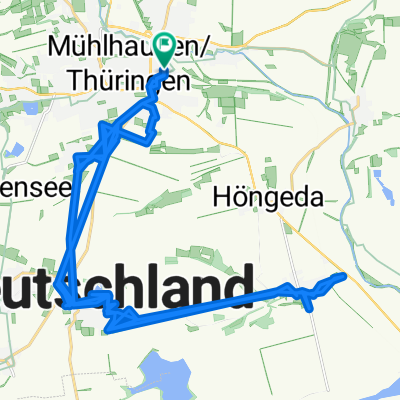
UHW 002: Mühlhausen/Thür. - Wolfsbrunnen über Berka v. d. Hainich
A cycling route starting in Mühlhausen, Thuringia, Germany.
Overview
About this route
MÜHLHAUSEN - Höngeda - Seebach - Alterstdt - Forsthaus Thiemsburg - Craula - Craulaer Kreuz - Hainich - Berka v. d. H. - Bischofroda - Utteroda - Creuzburg - WERRA - Buchenau - WERRA - Mihla
Unfreiwillig: Harstallwiese - Schrecklicher Waldweg - 'Antoniusherberge' - Kammerforst - Lamgula - UWR (falsche Richtung!) - Oberdorla - UWR (falsche Richtung!) - Weidensee - K206 - L2104 - Heyerode - L2104 - UWR - Diedorf - UWR - Wendehausen - UWR - L1019 - Heldra
Wieder richtig: Bahnhof Großburschla - WERRA - Altenburschla - WERRA - Wanfried - R5 - Frieda - Schwebda - Schlß Wolfsbrunnen
- -:--
- Duration
- 109.3 km
- Distance
- 881 m
- Ascent
- 861 m
- Descent
- ---
- Avg. speed
- ---
- Max. altitude
Route quality
Waytypes & surfaces along the route
Waytypes
Track
28.4 km
(26 %)
Quiet road
25.1 km
(23 %)
Surfaces
Paved
62.3 km
(57 %)
Unpaved
18.6 km
(17 %)
Asphalt
56.8 km
(52 %)
Gravel
14.2 km
(13 %)
Route highlights
Points of interest along the route
Accommodation after 0 km
Hotel Weidenmühle
Point of interest after 48.6 km
Eispause am Marktplatz auf der Straßenterrasse der "Alten Posthalterei"
Accommodation after 109.3 km
Schloß Wolfsbrunnen
Continue with Bikemap
Use, edit, or download this cycling route
You would like to ride UHW 002: Mühlhausen/Thür. - Wolfsbrunnen über Berka v. d. Hainich or customize it for your own trip? Here is what you can do with this Bikemap route:
Free features
- Save this route as favorite or in collections
- Copy & plan your own version of this route
- Split it into stages to create a multi-day tour
- Sync your route with Garmin or Wahoo
Premium features
Free trial for 3 days, or one-time payment. More about Bikemap Premium.
- Navigate this route on iOS & Android
- Export a GPX / KML file of this route
- Create your custom printout (try it for free)
- Download this route for offline navigation
Discover more Premium features.
Get Bikemap PremiumFrom our community
Other popular routes starting in Mühlhausen
 gemütliche Tour UH
- Distance
- 43.1 km
- Ascent
- 73 m
- Descent
- 69 m
- Location
- Mühlhausen, Thuringia, Germany
 craula
- Distance
- 70.2 km
- Ascent
- 477 m
- Descent
- 494 m
- Location
- Mühlhausen, Thuringia, Germany
 Berghof Feierabend Tour Bier
- Distance
- 30.9 km
- Ascent
- 108 m
- Descent
- 107 m
- Location
- Mühlhausen, Thuringia, Germany
 Mittelschwere Route
- Distance
- 29.2 km
- Ascent
- 318 m
- Descent
- 252 m
- Location
- Mühlhausen, Thuringia, Germany
 2017-10-14: Mühlhausen - Heiligenstadt - Bad Sooden
- Distance
- 78 km
- Ascent
- 497 m
- Descent
- 548 m
- Location
- Mühlhausen, Thuringia, Germany
 Wahlstraße, Mühlhausen/Thüringen to Rückermainstraße, Würzburg
- Distance
- 244.7 km
- Ascent
- 2,068 m
- Descent
- 2,112 m
- Location
- Mühlhausen, Thuringia, Germany
 Wahlstraße, Mühlhausen/Thüringen to Rückermainstraße, Würzburg
- Distance
- 250.3 km
- Ascent
- 2,550 m
- Descent
- 2,592 m
- Location
- Mühlhausen, Thuringia, Germany
 Mühlhausen nach Sondershausen
- Distance
- 43.2 km
- Ascent
- 160 m
- Descent
- 170 m
- Location
- Mühlhausen, Thuringia, Germany
Open it in the app