

chachagua, cruz, invu, pechuga.
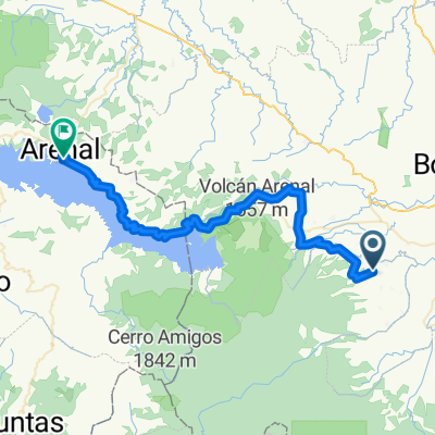
A cycling route starting in Poco Sol, Alajuela Province, Costa Rica.
Overview
About this route
- 45 min
- Duration
- 5.9 km
- Distance
- 13 m
- Ascent
- 127 m
- Descent
- 8 km/h
- Avg. speed
- ---
- Max. altitude

Route quality
Waytypes & surfaces along the route
Waytypes
Quiet road
5.9 km
(100 %)
Continue with Bikemap
Use, edit, or download this cycling route
You would like to ride chachagua, cruz, invu, pechuga. or customize it for your own trip? Here is what you can do with this Bikemap route:
Free features
- Save this route as favorite or in collections
- Copy & plan your own version of this route
- Sync your route with Garmin or Wahoo
Premium features
Free trial for 3 days, or one-time payment. More about Bikemap Premium.
- Navigate this route on iOS & Android
- Export a GPX / KML file of this route
- Create your custom printout (try it for free)
- Download this route for offline navigation
Discover more Premium features.
Get Bikemap PremiumFrom our community
Other popular routes starting in Poco Sol
 La Fortuna - Tilaran
- Distance
- 61.1 km
- Ascent
- 1,403 m
- Descent
- 1,012 m
- Location
- Poco Sol, Alajuela Province, Costa Rica
 Los conquistados
- Distance
- 16 km
- Ascent
- 400 m
- Descent
- 356 m
- Location
- Poco Sol, Alajuela Province, Costa Rica
 Lago Arenal ida y vuelta desde Poder
- Distance
- 70.9 km
- Ascent
- 743 m
- Descent
- 743 m
- Location
- Poco Sol, Alajuela Province, Costa Rica
 2011.06.02 - National Championships Costa Rica T.T.
- Distance
- 40.1 km
- Ascent
- 113 m
- Descent
- 120 m
- Location
- Poco Sol, Alajuela Province, Costa Rica
 poder
poder- Distance
- 14.9 km
- Ascent
- 334 m
- Descent
- 368 m
- Location
- Poco Sol, Alajuela Province, Costa Rica
 Preparatorio inclinado
- Distance
- 3 km
- Ascent
- 496 m
- Descent
- 242 m
- Location
- Poco Sol, Alajuela Province, Costa Rica
 Tigra
Tigra- Distance
- 12.9 km
- Ascent
- 211 m
- Descent
- 185 m
- Location
- Poco Sol, Alajuela Province, Costa Rica
 Los pedalistas
- Distance
- 5.3 km
- Ascent
- 136 m
- Descent
- 208 m
- Location
- Poco Sol, Alajuela Province, Costa Rica
Open it in the app