

Maasmechelen - Ründchen Nationaal Park Hoge Kempen ab Kikmolen 2019
A cycling route starting in Maasmechelen, Flemish Region, Belgium.
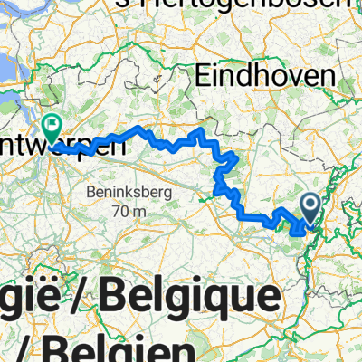
Overview
About this route
- -:--
- Duration
- 39.9 km
- Distance
- 126 m
- Ascent
- 125 m
- Descent
- ---
- Avg. speed
- ---
- Max. altitude

Route quality
Waytypes & surfaces along the route
Waytypes
Cycleway
14.7 km
(37 %)
Quiet road
13.1 km
(33 %)
Surfaces
Paved
21.2 km
(53 %)
Unpaved
7.7 km
(19 %)
Asphalt
12.8 km
(32 %)
Paved (undefined)
4.5 km
(11 %)
Continue with Bikemap
Use, edit, or download this cycling route
You would like to ride Maasmechelen - Ründchen Nationaal Park Hoge Kempen ab Kikmolen 2019 or customize it for your own trip? Here is what you can do with this Bikemap route:
Free features
- Save this route as favorite or in collections
- Copy & plan your own version of this route
- Sync your route with Garmin or Wahoo
Premium features
Free trial for 3 days, or one-time payment. More about Bikemap Premium.
- Navigate this route on iOS & Android
- Export a GPX / KML file of this route
- Create your custom printout (try it for free)
- Download this route for offline navigation
Discover more Premium features.
Get Bikemap PremiumFrom our community
Other popular routes starting in Maasmechelen
 Limburg, zelfgemaakt 3
- Distance
- 16.6 km
- Ascent
- 13 m
- Descent
- 16 m
- Location
- Maasmechelen, Flemish Region, Belgium
 limburg - the best biking routes at the Maas
- Distance
- 58.8 km
- Ascent
- 134 m
- Descent
- 135 m
- Location
- Maasmechelen, Flemish Region, Belgium
 Grensmaas in twee dagen
- Distance
- 86.1 km
- Ascent
- 175 m
- Descent
- 158 m
- Location
- Maasmechelen, Flemish Region, Belgium
 LanaGroen
- Distance
- 25.5 km
- Ascent
- 253 m
- Descent
- 253 m
- Location
- Maasmechelen, Flemish Region, Belgium
 Maasmechelen Fietsen 210,83 km - mei 13
- Distance
- 223.8 km
- Ascent
- 652 m
- Descent
- 685 m
- Location
- Maasmechelen, Flemish Region, Belgium
 Slingerberg Kann
- Distance
- 56.5 km
- Ascent
- 175 m
- Descent
- 173 m
- Location
- Maasmechelen, Flemish Region, Belgium
 Maaslandroute
- Distance
- 59.5 km
- Ascent
- 58 m
- Descent
- 55 m
- Location
- Maasmechelen, Flemish Region, Belgium
 Maasmechelen 28 km
- Distance
- 28.1 km
- Ascent
- 60 m
- Descent
- 69 m
- Location
- Maasmechelen, Flemish Region, Belgium
Open it in the app