
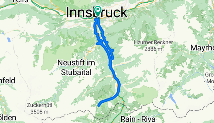
Innsbruck - Obernberger See und zurück
A cycling route starting in Innsbruck, Tyrol, Austria.
Overview
About this route
Anfahrt zum Aufwärmen über die Bundesstrasse bis Gries am Brenner, dann über einen steileren Abschnitt rauf zum Obernberger See, die letzten paar Hundert Meter sind steile grobe Schotterwege daher Rennrad schieben (mit Trekkinkrad und Mountainbike fahren möglich), schön gelegenes Ausflugslokal direkt am See, retour bis Matrei am Brenner, von dort über eine kurvige Strecke mit leichteren bis mittleren Anstiegen und tollem Ausblick über das Wipptal (Pfons - Ellbögen - Patsch) weiter über eine steile Abfahrt (bis 11%) über Igls und Vill zurück nach Innsbruck
- -:--
- Duration
- 87.2 km
- Distance
- 1,104 m
- Ascent
- 1,104 m
- Descent
- ---
- Avg. speed
- ---
- Avg. speed
Route quality
Waytypes & surfaces along the route
Waytypes
Busy road
60.5 km
(69 %)
Track
9.2 km
(11 %)
Surfaces
Paved
54.3 km
(62 %)
Unpaved
5.1 km
(6 %)
Asphalt
51.3 km
(59 %)
Paved (undefined)
2.8 km
(3 %)
Continue with Bikemap
Use, edit, or download this cycling route
You would like to ride Innsbruck - Obernberger See und zurück or customize it for your own trip? Here is what you can do with this Bikemap route:
Free features
- Save this route as favorite or in collections
- Copy & plan your own version of this route
- Split it into stages to create a multi-day tour
- Sync your route with Garmin or Wahoo
Premium features
Free trial for 3 days, or one-time payment. More about Bikemap Premium.
- Navigate this route on iOS & Android
- Export a GPX / KML file of this route
- Create your custom printout (try it for free)
- Download this route for offline navigation
Discover more Premium features.
Get Bikemap PremiumFrom our community
Other popular routes starting in Innsbruck
 Innsbruck - Viggarspitze
- Distance
- 16.9 km
- Ascent
- 1,750 m
- Descent
- 61 m
- Location
- Innsbruck, Tyrol, Austria
 IBK-Axamer Lizum-IBK
- Distance
- 46.6 km
- Ascent
- 1,175 m
- Descent
- 1,178 m
- Location
- Innsbruck, Tyrol, Austria
 Innsbruck - Imst_original 001
- Distance
- 62.1 km
- Ascent
- 588 m
- Descent
- 448 m
- Location
- Innsbruck, Tyrol, Austria
 IBK - Maria Waldrast - IBK
- Distance
- 62.1 km
- Ascent
- 1,628 m
- Descent
- 1,626 m
- Location
- Innsbruck, Tyrol, Austria
 Innsbruck - Treviso_2
- Distance
- 384.9 km
- Ascent
- 7,513 m
- Descent
- 8,079 m
- Location
- Innsbruck, Tyrol, Austria
 Nockspitz-Überschreitung
- Distance
- 54 km
- Ascent
- 2,398 m
- Descent
- 2,385 m
- Location
- Innsbruck, Tyrol, Austria
 Am Roßsprung 1, Innsbruck nach Am Roßsprung 1, Innsbruck
- Distance
- 40 km
- Ascent
- 622 m
- Descent
- 674 m
- Location
- Innsbruck, Tyrol, Austria
 Innsbruck II
- Distance
- 15.7 km
- Ascent
- 1,386 m
- Descent
- 0 m
- Location
- Innsbruck, Tyrol, Austria
Open it in the app