

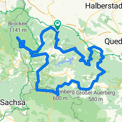
Wernigerode -> Walkenried -> Thale Hbf.
A cycling route starting in Wernigerode, Saxony-Anhalt, Germany.
Overview
About this route
Straße von Hohen Annen nach Elend war gesperrt, deshalb exzessive Auswegsuche in Schierke, die Lösung war ein Schotterweg im Elendstal (ja, das heißt wirklich so). Die Abfahrt aus Hasselfelde über die B81 war widerwärtig, besser über B242, Stiege & Allrode. Preiswertes Mittagessen (bis ca. 14 Uhr) im "Hotel zum Goldenen Löwen" in Walkenried.
- -:--
- Duration
- 94.4 km
- Distance
- 1,169 m
- Ascent
- 1,017 m
- Descent
- ---
- Avg. speed
- 636 m
- Max. altitude

Route quality
Waytypes & surfaces along the route
Waytypes
Track
12.3 km
(13 %)
Quiet road
10.4 km
(11 %)
Surfaces
Paved
69.8 km
(74 %)
Unpaved
12.3 km
(13 %)
Asphalt
69.8 km
(74 %)
Gravel
7.5 km
(8 %)
Continue with Bikemap
Use, edit, or download this cycling route
You would like to ride Wernigerode -> Walkenried -> Thale Hbf. or customize it for your own trip? Here is what you can do with this Bikemap route:
Free features
- Save this route as favorite or in collections
- Copy & plan your own version of this route
- Split it into stages to create a multi-day tour
- Sync your route with Garmin or Wahoo
Premium features
Free trial for 3 days, or one-time payment. More about Bikemap Premium.
- Navigate this route on iOS & Android
- Export a GPX / KML file of this route
- Create your custom printout (try it for free)
- Download this route for offline navigation
Discover more Premium features.
Get Bikemap PremiumFrom our community
Other popular routes starting in Wernigerode
 Brocken
- Distance
- 19.3 km
- Ascent
- 1,037 m
- Descent
- 157 m
- Location
- Wernigerode, Saxony-Anhalt, Germany
 Wurmberg
- Distance
- 57.2 km
- Ascent
- 1,056 m
- Descent
- 916 m
- Location
- Wernigerode, Saxony-Anhalt, Germany
 Brockenrunde
- Distance
- 153 km
- Ascent
- 2,210 m
- Descent
- 2,116 m
- Location
- Wernigerode, Saxony-Anhalt, Germany
 Wernigerode HarzW-134km (RK) Königsetappe
- Distance
- 133.8 km
- Ascent
- 1,425 m
- Descent
- 1,425 m
- Location
- Wernigerode, Saxony-Anhalt, Germany
 Brockentour
- Distance
- 39.9 km
- Ascent
- 1,133 m
- Descent
- 977 m
- Location
- Wernigerode, Saxony-Anhalt, Germany
 Wernigerode HarzW-126km (RK)
- Distance
- 125.4 km
- Ascent
- 1,866 m
- Descent
- 1,550 m
- Location
- Wernigerode, Saxony-Anhalt, Germany
 Große Dammstraße 32, Wernigerode nach Große Dammstraße 32, Wernigerode
- Distance
- 16.5 km
- Ascent
- 16 m
- Descent
- 7 m
- Location
- Wernigerode, Saxony-Anhalt, Germany
 Eine kleine Abendrunde bei Wernigerode
- Distance
- 24.2 km
- Ascent
- 125 m
- Descent
- 125 m
- Location
- Wernigerode, Saxony-Anhalt, Germany
Open it in the app