

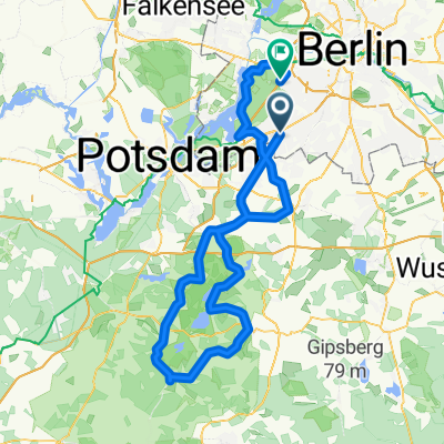
Dobbrikow andersrum
A cycling route starting in Zehlendorf, State of Berlin, Germany.
Overview
About this route
Eine der vielen Dobbrikow-Variationen; die Strecke über Ruhlsdorf ist aber nur sonntags zu empfehlen.
Das Teilsürck zwischen Blankensee und Trebbin ist extrem windanfällig - der kommt aber in der Regel aus Westen und stört somit bei der vorgeschlagenen Fahrtrichtung nicht, ganz im Gegenteil.
In Dobbrikow ist die Einkehr in der 'Scheune', einem Biergarten für Mofa-Fahrer(innen) empfehlenswert.
- -:--
- Duration
- 111.2 km
- Distance
- 139 m
- Ascent
- 133 m
- Descent
- ---
- Avg. speed
- 57 m
- Max. altitude

Route quality
Waytypes & surfaces along the route
Waytypes
Road
40.4 km
(36 %)
Quiet road
21.3 km
(19 %)
Surfaces
Paved
99.7 km
(90 %)
Unpaved
1.1 km
(1 %)
Asphalt
88.1 km
(79 %)
Paving stones
6.3 km
(6 %)
Continue with Bikemap
Use, edit, or download this cycling route
You would like to ride Dobbrikow andersrum or customize it for your own trip? Here is what you can do with this Bikemap route:
Free features
- Save this route as favorite or in collections
- Copy & plan your own version of this route
- Split it into stages to create a multi-day tour
- Sync your route with Garmin or Wahoo
Premium features
Free trial for 3 days, or one-time payment. More about Bikemap Premium.
- Navigate this route on iOS & Android
- Export a GPX / KML file of this route
- Create your custom printout (try it for free)
- Download this route for offline navigation
Discover more Premium features.
Get Bikemap PremiumFrom our community
Other popular routes starting in Zehlendorf
 Dobbrikow andersrum
- Distance
- 111.2 km
- Ascent
- 139 m
- Descent
- 133 m
- Location
- Zehlendorf, State of Berlin, Germany
 Flache Cross-Runde Berlin-Südwest
- Distance
- 42.1 km
- Ascent
- 114 m
- Descent
- 111 m
- Location
- Zehlendorf, State of Berlin, Germany
 Radtour Südlich von Berlin
- Distance
- 68.2 km
- Ascent
- 117 m
- Descent
- 117 m
- Location
- Zehlendorf, State of Berlin, Germany
 grunerunde
- Distance
- 31.4 km
- Ascent
- 181 m
- Descent
- 178 m
- Location
- Zehlendorf, State of Berlin, Germany
 S Zehlendorf -> Tremsdorf -> Caputh -> Auerbachtunnel
- Distance
- 65.4 km
- Ascent
- 258 m
- Descent
- 245 m
- Location
- Zehlendorf, State of Berlin, Germany
 Zehlendorf -> Fresdorf -> Caputh -> Teufelsberg
- Distance
- 85.4 km
- Ascent
- 298 m
- Descent
- 287 m
- Location
- Zehlendorf, State of Berlin, Germany
 RTF 24. Eichh. 2. Runde
- Distance
- 40.5 km
- Ascent
- 112 m
- Descent
- 116 m
- Location
- Zehlendorf, State of Berlin, Germany
 Berliner Mauerweg
- Distance
- 172.8 km
- Ascent
- 175 m
- Descent
- 181 m
- Location
- Zehlendorf, State of Berlin, Germany
Open it in the app