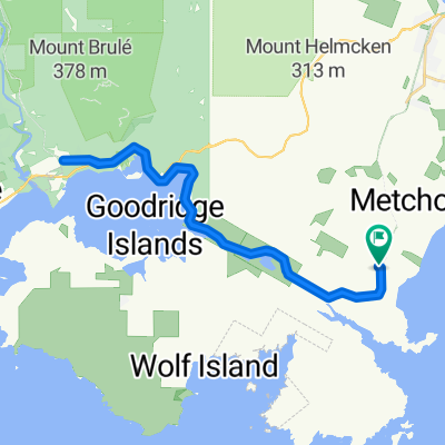
Matheson Lake to Luxton Area
A cycling route starting in Metchosin, British Columbia, Canada.
Overview
About this route
- -:--
- Duration
- 14.6 km
- Distance
- 166 m
- Ascent
- 154 m
- Descent
- ---
- Avg. speed
- ---
- Max. altitude
Route quality
Waytypes & surfaces along the route
Waytypes
Cycleway
10.2 km
(70 %)
Road
3.7 km
(25 %)
Surfaces
Paved
4 km
(28 %)
Unpaved
9.8 km
(68 %)
Gravel
9.8 km
(68 %)
Asphalt
3.8 km
(26 %)
Continue with Bikemap
Use, edit, or download this cycling route
You would like to ride Matheson Lake to Luxton Area or customize it for your own trip? Here is what you can do with this Bikemap route:
Free features
- Save this route as favorite or in collections
- Copy & plan your own version of this route
- Sync your route with Garmin or Wahoo
Premium features
Free trial for 3 days, or one-time payment. More about Bikemap Premium.
- Navigate this route on iOS & Android
- Export a GPX / KML file of this route
- Create your custom printout (try it for free)
- Download this route for offline navigation
Discover more Premium features.
Get Bikemap PremiumFrom our community
Other popular routes starting in Metchosin
- 4975 Deer Park Trail, Metchosin to 5341 Sooke Rd, Sooke
- Distance
- 12 km
- Ascent
- 81 m
- Descent
- 195 m
- Location
- Metchosin, British Columbia, Canada
- 2016 - Canada - Jour 2
- Distance
- 100.2 km
- Ascent
- 791 m
- Descent
- 783 m
- Location
- Metchosin, British Columbia, Canada
- Galloping Goose Trail, Victoria to Sooke Road 5225
- Distance
- 9.5 km
- Ascent
- 10 m
- Descent
- 36 m
- Location
- Metchosin, British Columbia, Canada
- Willing Drive 768, Victoria to Willing Drive 768, Victoria
- Distance
- 22.8 km
- Ascent
- 31 m
- Descent
- 106 m
- Location
- Metchosin, British Columbia, Canada
- Matheson to Sooke
- Distance
- 11 km
- Ascent
- 108 m
- Descent
- 119 m
- Location
- Metchosin, British Columbia, Canada
- Matheson Lake to Luxton Area
- Distance
- 14.6 km
- Ascent
- 166 m
- Descent
- 154 m
- Location
- Metchosin, British Columbia, Canada
- Willing Drive 778, Victoria to Willing Drive 768, Victoria
- Distance
- 24.7 km
- Ascent
- 90 m
- Descent
- 140 m
- Location
- Metchosin, British Columbia, Canada
- Boulderpath - Mallahat Pass Ride
- Distance
- 54 km
- Ascent
- 575 m
- Descent
- 575 m
- Location
- Metchosin, British Columbia, Canada
Open it in the app