

Gilgenberg am Weilhart-Runde
A cycling route starting in Dorfbeuern, Salzburg, Austria.
Overview
About this route
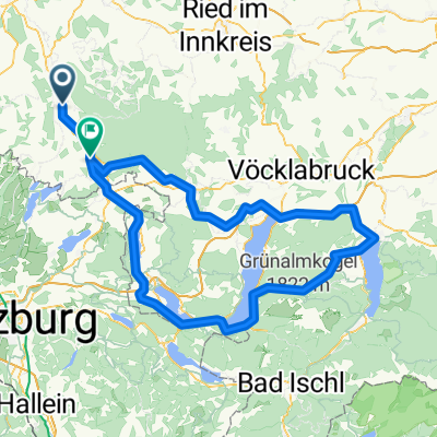
The loop starts and ends in Dorfibm at the Zehentnerhof. It first heads north to Mühlberg. There, turn left, cross the L504 towards Werberg, and continue to the turn (right!) into the Weilhartinger Forest. From there, ride through the Weilhartinger Forest to Hochburg-Ach. From Hochburg, go in a north-easterly direction. You cross a small section of the Weilhartinger Forest again, pass the Antonius Chapel, and reach Ruderstallgassen. From here, continue straight to Bitzlthal and then on to Gilgenberg am Weilhart. At the entrance to Gilgenberg, turn left up a steep path north for about 250 m; at the top, cross the Gilgenberg district road and ride about 1.2 km southeast. Then turn right (south) towards Zeisberg. There, turn left onto state road 1029 and follow it east for about 500 m. Turn right off the L1029 towards Lohnsberg, heading south through the hamlet of Dick to Krainburg. In Krainburg, turn right onto the unfortunately very busy L503. Ride roughly 500 m west, then turn left again into the Weilhartinger Forest towards the gravel works, and once more left through the woods to the Hubertus Chapel. The route then leads south to Reith / Gasteig, Geretsberg, Mühlberg, and finally to the finish point in Dorfibm, Zehentnerhof.
- -:--
- Duration
- 28.5 km
- Distance
- 367 m
- Ascent
- 367 m
- Descent
- ---
- Avg. speed
- 515 m
- Max. altitude

Route quality
Waytypes & surfaces along the route
Waytypes
Quiet road
23.1 km
(81 %)
Track
3.1 km
(11 %)
Surfaces
Paved
1.4 km
(5 %)
Unpaved
5.7 km
(20 %)
Loose gravel
5.4 km
(19 %)
Paved (undefined)
1.4 km
(5 %)
Continue with Bikemap
Use, edit, or download this cycling route
You would like to ride Gilgenberg am Weilhart-Runde or customize it for your own trip? Here is what you can do with this Bikemap route:
Free features
- Save this route as favorite or in collections
- Copy & plan your own version of this route
- Sync your route with Garmin or Wahoo
Premium features
Free trial for 3 days, or one-time payment. More about Bikemap Premium.
- Navigate this route on iOS & Android
- Export a GPX / KML file of this route
- Create your custom printout (try it for free)
- Download this route for offline navigation
Discover more Premium features.
Get Bikemap PremiumFrom our community
Other popular routes starting in Dorfbeuern
 Gilgenberg am Weilhart-Runde
- Distance
- 28.5 km
- Ascent
- 367 m
- Descent
- 367 m
- Location
- Dorfbeuern, Salzburg, Austria
 Mattighofen - Gaisberg - Mattighofen
- Distance
- 112.6 km
- Ascent
- 1,961 m
- Descent
- 1,931 m
- Location
- Dorfbeuern, Salzburg, Austria
 Neukirchen Wimpassing Fuschl am See
- Distance
- 48.8 km
- Ascent
- 636 m
- Descent
- 424 m
- Location
- Dorfbeuern, Salzburg, Austria
 3 Berge - Kobernaußerwaldschleife
- Distance
- 99.9 km
- Ascent
- 1,000 m
- Descent
- 1,000 m
- Location
- Dorfbeuern, Salzburg, Austria
 2 Tage: Mattighofen - Gmunden - Mattighofen
- Distance
- 155.3 km
- Ascent
- 2,340 m
- Descent
- 2,248 m
- Location
- Dorfbeuern, Salzburg, Austria
 Seenrundfahrt-Seelentium
- Distance
- 59.8 km
- Ascent
- 290 m
- Descent
- 290 m
- Location
- Dorfbeuern, Salzburg, Austria
 Dorfibm - Sankt Georgen am Fillmannsbach
- Distance
- 29.1 km
- Ascent
- 246 m
- Descent
- 246 m
- Location
- Dorfbeuern, Salzburg, Austria
 Mattighofen - Feldkirchen - Mattighofen
- Distance
- 41.3 km
- Ascent
- 462 m
- Descent
- 462 m
- Location
- Dorfbeuern, Salzburg, Austria
Open it in the app