Unbenannte Route
- 15.4 km
- 545 m
- 408 m
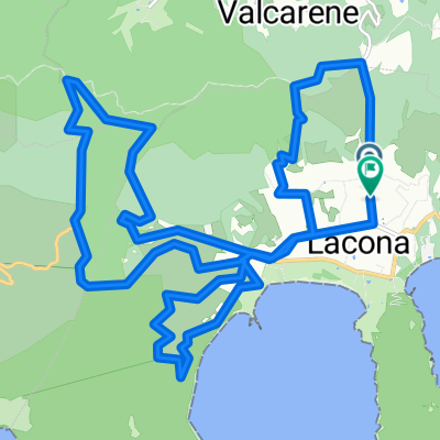
- Portoferraio, Tuscany, Italy
A cycling route starting in Portoferraio, Tuscany, Italy.
Overview
The start and finish point is the 'Scaglieri' campsite. From there, the route leads to Procchio and further towards Marciana Marina. In Redinoce (just before Marciana Marina), the route turns left through the village of Redinoce, ascending via Via del Pini to SP 25. On this road, you continue into Poggio. A visit to Poggio is highly recommended!!! From Poggio, the lightly trafficked SP 37 climbs up to the parking area at Monte Perone (630 m), which can only be reached on foot. Then you descend on SP 37 to Sant'Ilario, which is circled around. Afterwards, you go down to 'La Pila' and from there return to Procchio via SP 25 and back to Scaglieri via SP 24.
created this 6 years ago
Route quality
Road
16.5 km
(43 %)
Quiet road
3.1 km
(8 %)
Paved
31.4 km
(82 %)
Unpaved
1.5 km
(4 %)
Asphalt
31.4 km
(82 %)
Ground
1.5 km
(4 %)
Undefined
5.4 km
(14 %)
Continue with Bikemap
You would like to ride Poggio / Monte Perone or customize it for your own trip? Here is what you can do with this Bikemap route:
Free trial for 3 days, or one-time payment. More about Bikemap Premium.
Discover more Premium features.
Get Bikemap PremiumFrom our community
Open it in the app