

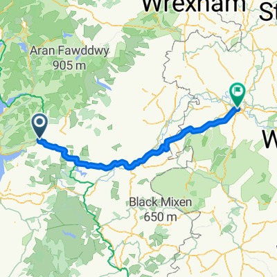
cwrt to Tegfryn
A cycling route starting in Machynlleth, Wales, United Kingdom.
Overview
About this route
- 18 min
- Duration
- 4.9 km
- Distance
- 40 m
- Ascent
- 54 m
- Descent
- 16.9 km/h
- Avg. speed
- ---
- Max. altitude

Continue with Bikemap
Use, edit, or download this cycling route
You would like to ride cwrt to Tegfryn or customize it for your own trip? Here is what you can do with this Bikemap route:
Free features
- Save this route as favorite or in collections
- Copy & plan your own version of this route
- Sync your route with Garmin or Wahoo
Premium features
Free trial for 3 days, or one-time payment. More about Bikemap Premium.
- Navigate this route on iOS & Android
- Export a GPX / KML file of this route
- Create your custom printout (try it for free)
- Download this route for offline navigation
Discover more Premium features.
Get Bikemap PremiumFrom our community
Other popular routes starting in Machynlleth
 Machynlleth to Aberystwyth
- Distance
- 33 km
- Ascent
- 503 m
- Descent
- 417 m
- Location
- Machynlleth, Wales, United Kingdom
 13 Machynlleth - Maentwrog
- Distance
- 63.4 km
- Ascent
- 854 m
- Descent
- 873 m
- Location
- Machynlleth, Wales, United Kingdom
 231126 Traws Eryri Final Official 1/7/23
- Distance
- 195.3 km
- Ascent
- ---
- Descent
- ---
- Location
- Machynlleth, Wales, United Kingdom
 LEJOG_D5low
- Distance
- 138.6 km
- Ascent
- 1,184 m
- Descent
- 1,126 m
- Location
- Machynlleth, Wales, United Kingdom
 LEJOG D5
- Distance
- 160.6 km
- Ascent
- 1,475 m
- Descent
- 1,417 m
- Location
- Machynlleth, Wales, United Kingdom
 Mach to Shrews
- Distance
- 100.4 km
- Ascent
- 702 m
- Descent
- 652 m
- Location
- Machynlleth, Wales, United Kingdom
 LEJOG_D5.2
- Distance
- 143.3 km
- Ascent
- 1,371 m
- Descent
- 1,313 m
- Location
- Machynlleth, Wales, United Kingdom
 Traws Eryri
- Distance
- 195.4 km
- Ascent
- 3,328 m
- Descent
- 3,329 m
- Location
- Machynlleth, Wales, United Kingdom
Open it in the app